Outline of North Dakota territorial evolution

Last updated
An expandable map of the United States after the Treaty of Paris in 1789 United States 1789-03-1789-08.png
An expandable map of the United States after the Treaty of Paris in 1789

The following outline traces the territorial evolution of the U.S. State of North Dakota .

Contents

Outline

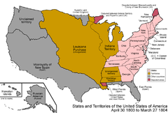
An enlargeable map of the United States after the Louisiana Purchase in 1803 United States 1803-04-1804-03.png
An enlargeable map of the United States after the Louisiana Purchase in 1803
An enlargeable map of the United States after the Anglo-American Convention of 1818 United States 1818-10-1818-12.png
An enlargeable map of the United States after the Anglo-American Convention of 1818
An enlargeable map of the United States after the Dakota Organic Act of 1861 United States 1861-03-1861-08.png
An enlargeable map of the United States after the Dakota Organic Act of 1861
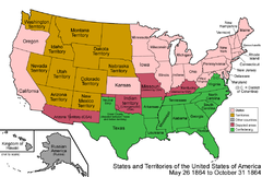
An enlargeable map of the United States after the Montana Organic Act of 1864 United States 1864-05-1864-10.png
An enlargeable map of the United States after the Montana Organic Act of 1864
An enlargeable map of the United States after North Dakota statehood in 1889 United States 1889-11-02-1889-11-08.png
An enlargeable map of the United States after North Dakota statehood in 1889
An enlargeable map of the United States as it has been since 1959 United States 1959-08-present.png
An enlargeable map of the United States as it has been since 1959

See also

Flag of Minnesota.svg Territorial evolution of Minnesota
Flag of Montana.svg Territorial evolution of Montana
Flag of South Dakota.svg Territorial evolution of South Dakota

Related Research Articles

<span class="mw-page-title-main">Louisiana Territory</span> Territory of the United States of America from 1805 to 1812

The Territory of Louisiana or Louisiana Territory was an organized incorporated territory of the United States that existed from July 4, 1805, until June 4, 1812, when it was renamed the Missouri Territory. The territory was formed out of the District of Louisiana, which consisted of the portion of the Louisiana Purchase north of the 33rd parallel.

<span class="mw-page-title-main">Michigan Territory</span> Territory of the US, 1805–1837

The Territory of Michigan was an organized incorporated territory of the United States that existed from June 30, 1805, until January 26, 1837, when the final extent of the territory was admitted to the Union as the State of Michigan. Detroit was the territorial capital.

<span class="mw-page-title-main">District of Louisiana</span> Territory of the USA between 1804-1805

The District of Louisiana, or Louisiana District, was an official and temporary United States government designation for the portion of the Louisiana Purchase that had not been organized into the Territory of Orleans or "Orleans Territory". The district officially existed from March 10, 1804, until July 4, 1805, when it was organized as the Louisiana Territory.

<span class="mw-page-title-main">Historical regions of the United States</span>

The territory of the United States and its overseas possessions has evolved over time, from the colonial era to the present day. It includes formally organized territories, proposed and failed states, unrecognized breakaway states, international and interstate purchases, cessions, and land grants, and historical military departments and administrative districts. The last section lists informal regions from American vernacular geography known by popular nicknames and linked by geographical, cultural, or economic similarities, some of which are still in use today.

<span class="mw-page-title-main">Outline of Arkansas</span> Overview of and topical guide to Arkansas

The following outline is provided as an overview of and topical guide to the U.S. state of Arkansas:

<span class="mw-page-title-main">Outline of Iowa</span> Overview of and topical guide to Iowa

The following outline is provided as an overview of and topical guide to the U.S. state of Iowa.

<span class="mw-page-title-main">Outline of Montana</span> Overview of and topical guide to Montana

The following outline is provided as an overview of and topical guide to the U.S. state of Montana:

<span class="mw-page-title-main">Outline of Kansas</span> Overview of and topical guide to Kansas

The following outline is provided as an overview of and topical guide to the U.S. state of Kansas:

<span class="mw-page-title-main">Outline of Minnesota</span> Overview of and topical guide to Minnesota

The following outline is provided as an overview of and topical guide to the U.S. state of Minnesota:

<span class="mw-page-title-main">Outline of Missouri</span> Overview of and topical guide to Missouri

The following outline is provided as an overview of and topical guide to the U.S. state of Missouri:
<span class="mw-page-title-main">Outline of Nebraska</span> Overview of and topical guide to Nebraska

The following outline is provided as an overview of and topical guide to the U.S. state of Nebraska:
<span class="mw-page-title-main">Outline of North Dakota</span> Overview of and topical guide to North Dakota

The following outline is provided as an overview of and topical guide to the U.S. state of North Dakota:

<span class="mw-page-title-main">Outline of South Dakota</span> Overview of and topical guide to South Dakota

The following outline is provided as an overview of and topical guide to South Dakota:

<span class="mw-page-title-main">Outline of Wyoming</span> Overview of and topical guide to Wyoming

The following outline is provided as an overview of and topical guide to the U.S. state of Wyoming:
<span class="mw-page-title-main">Territorial evolution of New Mexico</span> Geographic chronology of New Mexico

The area currently occupied by the U.S. State of New Mexico has undergone numerous changes in occupancy and territorial claims and designations. This geographic chronology traces the territorial evolution of New Mexico.

<span class="mw-page-title-main">Outline of Wyoming territorial evolution</span>

The following outline traces the territorial evolution of the U.S. State of Wyoming.

<span class="mw-page-title-main">Territorial evolution of Montana</span>

The following chronology traces the territorial evolution of the U.S. State of Montana.

<span class="mw-page-title-main">Territorial evolution of South Dakota</span>

The following outline traces the territorial evolution of the U.S. State of South Dakota.

This timeline of South Dakota is a list of events in the history of South Dakota by year.

References

  1. Thirty-sixth United States Congress (March 2, 1861). "An Act to provide a temporary Government for the Territory of Dakota, and to create the Office of Surveyor General therein" (cgi-bin). Retrieved June 16, 2009.
  2. Benjamin Harrison (November 2, 1889). "By the President of the United States of America, A Proclamation Admitting the State of North Dakota to the Union" . Retrieved June 16, 2009.