Legend for maps
U.S. stateU.S. territoryClaimed by other countriesDisputed

The following outline traces the territorial evolution of the U.S. state of Oregon .
Legend for maps
U.S. stateU.S. territoryClaimed by other countriesDisputed
The following outline traces the territorial evolution of the U.S. state of Oregon .


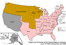


The Territory of Oregon was an organized incorporated territory of the United States that existed from August 14, 1848, until February 14, 1859, when the southwestern portion of the territory was admitted to the Union as the State of Oregon. Originally claimed by several countries, Spanish "El Orejón" was part of the Territorio de Nutca (1789–1795), later in the 19th century, the region was divided between the British Empire and the US in 1846. When established, the territory encompassed an area that included the current states of Oregon, Washington, and Idaho, as well as parts of Wyoming and Montana. The capital of the territory was first Oregon City, then Salem, followed briefly by Corvallis, then back to Salem, which became the state capital upon Oregon's admission to the Union.

The territory of the United States and its overseas possessions has evolved over time, from the colonial era to the present day. It includes formally organized territories, proposed and failed states, unrecognized breakaway states, international and interstate purchases, cessions, and land grants, and historical military departments and administrative districts. The last section lists informal regions from American vernacular geography known by popular nicknames and linked by geographical, cultural, or economic similarities, some of which are still in use today.

Oregon pioneer history (1806–1890) is the period in the history of Oregon Country and Oregon Territory, in the present day state of Oregon and Northwestern United States.

The following outline is provided as an overview of and topical guide to the U.S. state of Idaho:

The following outline is provided as an overview of and topical guide to the U.S. state of Montana:

The following outline is provided as an overview of and topical guide to the U.S. state of Nevada:

The following outline is provided as an overview of and topical guide to the U.S. state of Oregon:

The following outline is provided as an overview of and topical guide to the U.S. state of Washington:

The following outline is provided as an overview of and topical guide to the U.S. state of Wyoming:
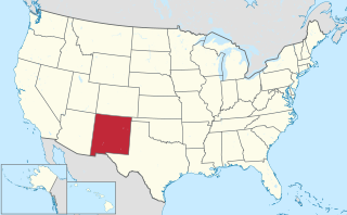
The area currently occupied by the U.S. State of New Mexico has undergone numerous changes in occupancy and territorial claims and designations. This geographic chronology traces the territorial evolution of New Mexico.

The following outline traces the territorial evolution of the U.S. State of Wyoming.
The following chronology traces the territorial evolution of the U.S. State of Montana.
The following chronology traces the territorial evolution of the U.S. State of Idaho.
The following outline traces the territorial evolution of the U.S. State of Washington.
The following timeline traces the territorial evolution of the U.S. State of Utah.
The following timeline traces the territorial evolution of the U.S. State of Arizona.
The following outline traces the territorial evolution of the U.S. State of Nevada.

The following timeline traces the territorial evolution of California, the thirty-first state admitted to the United States of America, including the process of removing Indigenous Peoples from their native lands, or restricting them to reservations.
The following outline traces the territorial evolution of the U.S. State of North Dakota.
The following outline traces the territorial evolution of the U.S. State of South Dakota.
| By country | |
|---|---|
| By former country | |
| By subdivision |
|
| By region |
|
| By country, people, region or period | |
| By international organisation | |