Territorial evolution of Idaho

Last updated
An enlargeable map of the United States after the Constitution of the United States was ratified on March 4, 1789. United States 1789-03-1789-08.png
An enlargeable map of the United States after the Constitution of the United States was ratified on March 4, 1789.
An enlargeable map of the United States after the Treaty of 1818 took effect on January 30, 1819. United States 1818-10-1818-12.png
An enlargeable map of the United States after the Treaty of 1818 took effect on January 30, 1819.
An enlargeable map of the United States after the Adams-Onis Treaty took effect on February 22, 1821. United States 1821-07-1821-08.png
An enlargeable map of the United States after the Adams–Onís Treaty took effect on February 22, 1821.
An enlargeable map of the United States after the Oregon Treaty took effect July 17, 1846 United States 1846-06-1846-12.png
An enlargeable map of the United States after the Oregon Treaty took effect July 17, 1846
An enlargeable map of the United States after the creation of the Territory of Oregon on August 14, 1848. United States 1848-08-1849.png
An enlargeable map of the United States after the creation of the Territory of Oregon on August 14, 1848.
An enlargeable map of the United States after the creation of the Territory of Washington on March 2, 1853. United States 1853-03-1853-12.png
An enlargeable map of the United States after the creation of the Territory of Washington on March 2, 1853.
An enlargeable map of the United States after the admission of Oregon to the Union on February 14, 1859. United States 1859-1860.png
An enlargeable map of the United States after the admission of Oregon to the Union on February 14, 1859.
An enlargeable map of the United States after the creation of the Territory of Idaho on March 3, 1863. United States 1863-03-1863-06.png
An enlargeable map of the United States after the creation of the Territory of Idaho on March 3, 1863.
An enlargeable map of the United States after the creation of the Territory of Montana on May 26, 1864. United States 1864-05-1864-10.png
An enlargeable map of the United States after the creation of the Territory of Montana on May 26, 1864.
An enlargeable map of the United States after the creation of the Territory of Wyoming on July 25, 1868. United States 1868-1876.png
An enlargeable map of the United States after the creation of the Territory of Wyoming on July 25, 1868.
An enlargeable map of the United States after the admission of Idaho to the Union on July 3 1890. United States 1890-07-03-1890-07-10.png
An enlargeable map of the United States after the admission of Idaho to the Union on July 3 1890.
An enlargeable map of the United States as it has been since Hawai`i was admitted to the Union on August 21, 1959. United States 1959-08-present.png
An enlargeable map of the United States as it has been since Hawaiʻi was admitted to the Union on August 21, 1959.

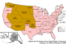
The following chronology traces the territorial evolution of the U.S. State of Idaho .

Contents

Timeline

See also

Flag of Montana.svg Territorial evolution of Montana
Flag of Nevada.svg Territorial evolution of Nevada
Flag of Oregon.svg Territorial evolution of Oregon
Flag of Utah.svg Territorial evolution of Utah
Flag of Washington.svg Territorial evolution of Washington
Flag of Wyoming.svg Territorial evolution of Wyoming

References

  1. Thirty-seventh United States Congress (March 3, 1863). "An Act to provide a temporary Government for the Territory of Idaho" (cgi-bin). Retrieved June 5, 2009.