Outline of Wyoming territorial evolution

Last updated

An enlargeable map of the United States after the Constitution of the United States was ratified on March 4, 1789. United States 1789-03-1789-08.png
An enlargeable map of the United States after the Constitution of the United States was ratified on March 4, 1789.
An enlargeable map of the United States after the secret Third Treaty of San Ildefonso transferred the Spanish colony of la Luisiana to the French Republic on October 1, 1800. United States 1800-07-10-1802.png
An enlargeable map of the United States after the secret Third Treaty of San Ildefonso transferred the Spanish colony of la Luisiana to the French Republic on October 1, 1800.
An enlargeable map of the United States after the Louisiana Purchase took effect on December 20, 1803. United States 1803-04-1804-03.png
An enlargeable map of the United States after the Louisiana Purchase took effect on December 20, 1803.
An enlargeable map of the United States after the creation of the District of Louisiana on March 26, 1804. United States 1804-10-1805-01.png
An enlargeable map of the United States after the creation of the District of Louisiana on March 26, 1804.
An enlargeable map of the United States after the creation of the Territory of Louisiana on March 3, 1805. United States 1805-07-1809.png
An enlargeable map of the United States after the creation of the Territory of Louisiana on March 3, 1805.
An enlargeable map of the United States after the creation of the Territory of Missouri on June 4, 1812. United States 1812-06-1812-12.png
An enlargeable map of the United States after the creation of the Territory of Missouri on June 4, 1812.
An enlargeable map of the United States after the Treaty of 1818 took effect on October 20, 1818. United States 1818-10-1818-12.png
An enlargeable map of the United States after the Treaty of 1818 took effect on October 20, 1818.
An enlargeable map of the United States after the Adams-Onis Treaty took effect on February 22, 1821. United States 1821-07-1821-08.png
An enlargeable map of the United States after the Adams–Onís Treaty took effect on February 22, 1821.
An enlargeable map of the United States after Missouri was admitted to the Union on August 10, 1821. United States 1821-08-1822.png
An enlargeable map of the United States after Missouri was admitted to the Union on August 10, 1821.
Territorial claims of the Republic of Texas, May 2, 1836. United States 1836-03-1836-06.png
Territorial claims of the Republic of Texas, May 2, 1836.
An enlargeable map of the United States after Texas was admitted to the Union on December 29, 1845. United States 1845-12-1846-06.png
An enlargeable map of the United States after Texas was admitted to the Union on December 29, 1845.
An enlargeable map of the United States after the Oregon Treaty took effect July 17, 1846 United States 1846-06-1846-12.png
An enlargeable map of the United States after the Oregon Treaty took effect July 17, 1846
An enlargeable map of the United States after the Treaty of Guadalupe Hidalgo was signed on February 2, 1848. United States 1848-02-1848-05.png
An enlargeable map of the United States after the Treaty of Guadalupe Hidalgo was signed on February 2, 1848.
An enlargeable map of the United States after the creation of the Territory of Oregon on August 14, 1848. United States 1848-08-1849.png
An enlargeable map of the United States after the creation of the Territory of Oregon on August 14, 1848.
An enlargeable map of the United States after the creation of the proposed State of Deseret on July 2, 1849. United States Central change 1849-03-12.png
An enlargeable map of the United States after the creation of the proposed State of Deseret on July 2, 1849.
An enlargeable map of the United States after the creation of the Territory of New Mexico and the Territory of Utah on September 9, 1850. United States 1850-1853-03.png
An enlargeable map of the United States after the creation of the Territory of New Mexico and the Territory of Utah on September 9, 1850.
An enlargeable map of the United States after the creation of the Territory of Kansas and the Territory of Nebraska on May 30, 1854. United States 1854-1858.png
An enlargeable map of the United States after the creation of the Territory of Kansas and the Territory of Nebraska on May 30, 1854.
An enlargeable map of the United States after the admission of Oregon to the Union on February 14, 1859. United States 1859-1860.png
An enlargeable map of the United States after the admission of Oregon to the Union on February 14, 1859.
An enlargeable map of the United States after the creation of the proposed Territory of Jefferson on October 24, 1859. United States Central change 1859-11-07.png
An enlargeable map of the United States after the creation of the proposed Territory of Jefferson on October 24, 1859.
An enlargeable map of the United States after the creation of the Territory of Dakota on March 2, 1861. United States 1861-03-1861-08.png
An enlargeable map of the United States after the creation of the Territory of Dakota on March 2, 1861.
An enlargeable map of the United States after the creation of the Territory of Idaho on March 3, 1863. United States 1863-03-1863-06.png
An enlargeable map of the United States after the creation of the Territory of Idaho on March 3, 1863.
An enlargeable map of the United States after the creation of the Territory of Montana on May 26, 1864. United States 1864-05-1864-10.png
An enlargeable map of the United States after the creation of the Territory of Montana on May 26, 1864.
An enlargeable map of the United States after the creation of the Territory of Wyoming on July 25, 1868. United States 1868-1876.png
An enlargeable map of the United States after the creation of the Territory of Wyoming on July 25, 1868.
An enlargeable map of the United States after the admission of Wyoming to the Union on July 10, 1890. United States 1890-07-10-1896-01.png
An enlargeable map of the United States after the admission of Wyoming to the Union on July 10, 1890.
An enlargeable map of the United States as it has been since Hawai`i was admitted to the Union on August 21, 1959. United States 1959-08-present.png
An enlargeable map of the United States as it has been since Hawaiʻi was admitted to the Union on August 21, 1959.

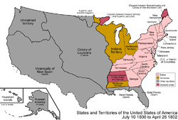
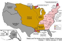
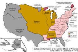
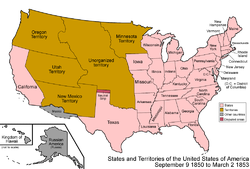
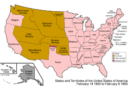
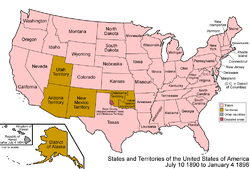
The following outline traces the territorial evolution of the U.S. State of Wyoming .

Contents

Outline

See also

Flag of Spain.svg Nueva España
Royal Flag of France.svg La Louisiane
Flag of Spain.svg La Luisiana
Flag of the United States.svg Louisiana Purchase
Flag of the United States.svg District of Louisiana
Flag of Missouri.svg Louisiana Territory
Flag of Missouri.svg Missouri Territory
Flag of Mexico.svg Mexican Empire
Flag of Texas.svg Republic of Texas
Flag of Oregon.svg Oregon Territory
Flag of Utah.svg Utah Territory
Flag of Washington.svg Washington Territory
Flag of Nebraska.svg Nebraska Territory
Flag of South Dakota.svg Dakota Territory
Flag of Idaho.svg Idaho Territory
Flag of Wyoming.svg Wyoming Territory
Flag of Wyoming.svg State of Wyoming

Related Research Articles

<span class="mw-page-title-main">District of Louisiana</span> Territory of the USA between 1804-1805

The District of Louisiana, or Louisiana District, was an official and temporary United States government designation for the portion of the Louisiana Purchase that had not been organized into the Territory of Orleans or "Orleans Territory". The district officially existed from March 10, 1804, until July 4, 1805, when it was organized as the Louisiana Territory.

<span class="mw-page-title-main">Historical regions of the United States</span>

The territory of the United States and its overseas possessions has evolved over time, from the colonial era to the present day. It includes formally organized territories, proposed and failed states, unrecognized breakaway states, international and interstate purchases, cessions, and land grants, and historical military departments and administrative districts. The last section lists informal regions from American vernacular geography known by popular nicknames and linked by geographical, cultural, or economic similarities, some of which are still in use today.

<span class="mw-page-title-main">Outline of Montana</span> Overview of and topical guide to Montana

The following outline is provided as an overview of and topical guide to the U.S. state of Montana:

<span class="mw-page-title-main">Outline of Kansas</span> Overview of and topical guide to Kansas

The following outline is provided as an overview of and topical guide to the U.S. state of Kansas:

<span class="mw-page-title-main">Outline of Minnesota</span> Overview of and topical guide to Minnesota

The following outline is provided as an overview of and topical guide to the U.S. state of Minnesota:

<span class="mw-page-title-main">Outline of Oklahoma</span> Overview of and topical guide to Oklahoma

The following outline is provided as an overview of and topical guide to the U.S. state of Oklahoma:

<span class="mw-page-title-main">Outline of Texas</span> Overview of and topical guide to Texas

The following outline is provided as an overview of and topical guide to Texas:

<span class="mw-page-title-main">Outline of Wyoming</span> Overview of and topical guide to Wyoming

The following outline is provided as an overview of and topical guide to the U.S. state of Wyoming:

<span class="mw-page-title-main">Territorial evolution of New Mexico</span> Geographic chronology of New Mexico

The area currently occupied by the U.S. State of New Mexico has undergone numerous changes in occupancy and territorial claims and designations. This geographic chronology traces the territorial evolution of New Mexico.

<span class="mw-page-title-main">Territorial evolution of Montana</span>

The following chronology traces the territorial evolution of the U.S. State of Montana.

<span class="mw-page-title-main">Territorial evolution of Idaho</span> An US state

The following chronology traces the territorial evolution of the U.S. State of Idaho.

<span class="mw-page-title-main">Outline of Washington territorial evolution</span> Overview of and topical guide to Washington territorial evolution

The following outline traces the territorial evolution of the U.S. State of Washington.

<span class="mw-page-title-main">Outline of Oregon territorial evolution</span> Overview of and topical guide to Oregon territorial evolution

The following outline traces the territorial evolution of the U.S. state of Oregon.

<span class="mw-page-title-main">Territorial evolution of Utah</span>

The following timeline traces the territorial evolution of the U.S. State of Utah.

<span class="mw-page-title-main">Territorial evolution of Arizona</span> Review of the topic

The following timeline traces the territorial evolution of the U.S. State of Arizona.

<span class="mw-page-title-main">Territorial evolution of Nevada</span>

The following outline traces the territorial evolution of the U.S. State of Nevada.

<span class="mw-page-title-main">Outline of North Dakota territorial evolution</span> Overview of and topical guide to North Dakota territorial evolution

The following outline traces the territorial evolution of the U.S. State of North Dakota.

<span class="mw-page-title-main">Territorial evolution of South Dakota</span>

The following outline traces the territorial evolution of the U.S. State of South Dakota.

<span class="mw-page-title-main">Territorial evolution of North America since 1763</span> Timeline of notable events

The 1763 Treaty of Paris ended the major war known by Americans as the French and Indian War and by Canadians as the Seven Years' War / Guerre de Sept Ans, or by French-Canadians, La Guerre de la Conquête. It was signed by Great Britain, France and Spain, with Portugal in agreement. Preferring to keep Guadeloupe, France gave up Canada and all of its claims to territory east of the Mississippi River to Britain. With France out of North America this dramatically changed the European political scene on the continent.

References

  1. Fortieth United States Congress (July 25, 1868). "An Act to provide a temporary Government for the Territory of Wyoming" (PDF). Library of Congress . Retrieved October 7, 2020.
  2. Fifty-first United States Congress (July 10, 1890). "An act to provide for the admission of the State of Wyoming into the Union, and for other purposes" (PDF). Library of Congress . Retrieved October 7, 2020.