| Flag | Date | Use | Description |
|---|
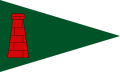 | 1972 | Cargreen Yacht Club | A green burgee defaced with a red brick chimney outlined in black in the hoist. |
 | 1921 | Flushing Sailing Club | A black burgee defaced with a gold letter "V". |
 | 1948 | Helford River Sailing Club | A blue burgee divided by a red cross outlined in white, with a gold ship in the centre. |
 | 1934 | Looe Sailing Club | A diagonally divided burgee of seven red and yellow stripes (four red and three yellow) defaced with a black silhouette of a ship on the waves. |
 | | Mount's Bay Sailing Club | |
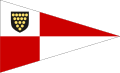
 | 1963 | Mylor Yacht Club | A white burgee divided by a red Saint George's Cross with the shield from the arms of the Duchy of Cornwall in the canton. |
 | 1965 | Padstow Sailing Club | A white burgee defaced with a red-and-white fish and surrounded by a blue border. |
 | 1939–1990s | Penzance Sailing Club | A white burgee defaced with a black skull and crossbones. [10] |
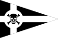 | 1990s | Penzance Sailing Club | A black burgee divided by a white Saint Piran's Cross, with a black skull and crossbones on a white disc in the centre. [10] |
 | 1958 | Port Navas Yacht Club | A black burgee with the white-coloured initials "PNYC" arranged vertically in the hoist and separated from the rest of the burgee by a vertical white line, and the rest of the burgee divided by a white Saint Piran's Cross with a gold ship's wheel to the upper left of the cross. |
 | 1951 | Porthpean Sailing Club | A blue burgee divided by a white cross, defaced in the centre with a white shield bearing a red saltire. |
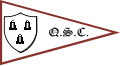 | 1974 | The Quay Sailing Club | A white burgee with a crimson border, defaced with a white shield containing three black bells (two above and one below) in the hoist, and the black-coloured initials "Q.S.C." in the fly. |
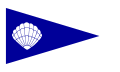 | 1933 | Restronguet Sailing Club | A blue burgee defaced with a white seashell and surrounded by a white border. |
 | 1938 | Rock Sailing and Waterski Club | A yellow burgee defaced with a black silhouette of a camel. |
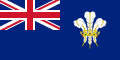  | 1871 | Royal Cornwall Yacht Club | Blue Ensign, with the Prince of Wales's feathers heraldic badge. [11] |
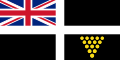
  | 1880 | Royal Fowey Yacht Club | Red Ensign, with the coat of arms of the Duke of Cornwall. [12] |
  | 1972 | St Ives Sailing Club | |
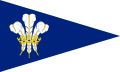
 | 1920 | St Mawes Sailing Club | A white-and-red quartered burgee with the shield from the arms of the Duchy of Cornwall in the canton. |
 | 1898 | Saltash Sailing Club | |
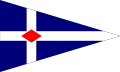 | 1891 | Torpoint Mosquito Sailing Club | A dark blue burgee divided by a white cross and defaced with a red diamond in the centre. |