Miers Bluff

Last updated
Location of Hurd Peninsula, Livingston Island in the South Shetland Islands. Hurd-Peninsula-location-map.png
Location of Hurd Peninsula, Livingston Island in the South Shetland Islands.
Miers Bluff (on the left) from Mount Friesland. Hurd-Peninsula.jpg
Miers Bluff (on the left) from Mount Friesland.
Topographic map of Livingston Island and Smith Island Livingston-Island-Map-2010-15.png
Topographic map of Livingston Island and Smith Island

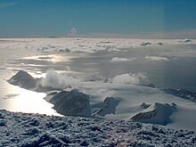
Miers Bluff is the point forming the southwest extremity of Hurd Peninsula, the southeast side of the entrance to South Bay and the northwest side of the entrance to False Bay, on Livingston Island in the South Shetland Islands, Antarctica. The name "Elephant Point", given by Robert Fildes in 1820–22 to another feature, has been for a number of years applied in error to this bluff. It is now approved as originally intended and a new name has been substituted for the feature here described.

Hurd Peninsula

Hurd Peninsula lies between South Bay and False Bay on the south coast of Livingston Island in the South Shetland Islands, Antarctica. The Spanish Juan Carlos I Antarctic Base and the Bulgarian St. Kliment Ohridski Base are situated on its west coast.

South Bay (Livingston Island) bay on Livingston Island in the South Shetland Islands, Antarctica

South Bay is a 11.6 kilometres (7.2 mi) wide bay indenting for 12.5 kilometres (7.8 mi) the south coast of Livingston Island in the South Shetland Islands, Antarctica. The bay is lying northwest of False Bay and east of Walker Bay, and is entered between Hannah Point and Miers Bluff. The glaciers Kamchiya, Pimpirev, Perunika, Contell, Johnsons and Hurd Ice Cap feed the bay.

False Bay (Livingston Island) bay of Livingston Island in the South Shetland Islands

False Bay is a bay 4 miles (6.4 km) long, which lies between Barnard Point and Miers Bluff on the south side of Livingston Island, in the South Shetland Islands, Antarctica. The glaciers Hurd Ice Cap, Huntress, Ruen Icefall, Peshtera and Charity feed the bay.

Contents

The point is named after John Miers, British engineer and botanist who travelled to Chile in 1818 and was responsible for the publication in 1820 of the first chart of the South Shetland Islands, based on the work of William Smith. [1]

John Miers (botanist) British botanist and engineer

John Miers, FRS FLS, knight grand cross of the Order of the Rose, was a British botanist and engineer, best known for his work on the flora of Chile and Argentina.

Chile Republic in South America

Chile, officially the Republic of Chile, is a South American country occupying a long, narrow strip of land between the Andes to the east and the Pacific Ocean to the west. It borders Peru to the north, Bolivia to the northeast, Argentina to the east, and the Drake Passage in the far south. Chilean territory includes the Pacific islands of Juan Fernández, Salas y Gómez, Desventuradas, and Easter Island in Oceania. Chile also claims about 1,250,000 square kilometres (480,000 sq mi) of Antarctica, although all claims are suspended under the Antarctic Treaty.

William Smith (mariner) English captain who discovered the South Shetland Islands

William Smith was the English captain born in Blyth, Northumberland, who discovered the South Shetland Islands, an archipelago off the Graham Land in Antarctica. His discovery was the first ever made south of 60° south latitude, in the present Antarctic Treaty area.

Location

The point is located at ( 62°43′12.3″S60°26′11.3″W / 62.720083°S 60.436472°W / -62.720083; -60.436472 Coordinates: 62°43′12.3″S60°26′11.3″W / 62.720083°S 60.436472°W / -62.720083; -60.436472 ) which is 6.6 kilometres (4.1 mi) northwest of Barnard Point, 11.5 kilometres (7.1 mi) southeast of Hannah Point and 7.8 kilometres (4.8 mi) southwest of Napier Peak (British mapping in 1968, detailed Spanish mapping in 1991, and Bulgarian mapping in 2005 and 2009). The U.S. Geological Survey gives the location as 62°43′S60°27′W / 62.717°S 60.450°W / -62.717; -60.450 . [1]

Geographic coordinate system Coordinate system

A geographic coordinate system is a coordinate system that enables every location on Earth to be specified by a set of numbers, letters or symbols. The coordinates are often chosen such that one of the numbers represents a vertical position and two or three of the numbers represent a horizontal position; alternatively, a geographic position may be expressed in a combined three-dimensional Cartesian vector. A common choice of coordinates is latitude, longitude and elevation. To specify a location on a plane requires a map projection.

Barnard Point

Barnard Point is a headland which marks the south-east side of the entrance to False Bay on the south side of Livingston Island in the South Shetland Islands, Antarctica. It is situated on Rozhen Peninsula, 1.5 km (1 mi) north-north-west of Botev Point and 6.6 km (4 mi) south-east of Miers Bluff.

Hannah Point

Hannah Point is a point on the south coast of Livingston Island in the South Shetland Islands, Antarctica. It forms the east side of the entrance to Walker Bay and the west side of the entrance to South Bay. Surmounted by Ustra Peak to the north, with Liverpool Beach extending between the peak and the tip of Hannah Point. Ice-free area ca. 122 hectares.

Maps

International Standard Book Number Unique numeric book identifier

The International Standard Book Number (ISBN) is a numeric commercial book identifier which is intended to be unique. Publishers purchase ISBNs from an affiliate of the International ISBN Agency.

Related Research Articles

Spanish Point (Antarctica)

Spanish Point is located on Bulgarian Beach on Hurd Peninsula, eastern Livingston Island in the South Shetland Islands, Antarctica formed by an offshoot of Spanish Knoll.

Desolation Island (South Shetland Islands)

Desolation Island is one of the minor islands in the South Shetlands archipelago, Antarctica situated at the entrance to Hero Bay, Livingston Island. The island is V-shaped with its northern coast indented by Kozma Cove. Surface area 3.12 square kilometres (1.20 sq mi).

McFarlane Strait

McFarlane Strait is a strait lying between Greenwich Island and Livingston Island, in the South Shetland Islands off Antarctica. It is 24 kilometres (13 nmi) long and 3 kilometres (1.6 nmi) wide. The name appears on an 1822 chart by Captain George Powell, a British sealer, and is now well established in international usage.

Johnsons Dock cove

Johnsons Dock is a sheltered 500 m wide cove indenting for 900 m the northwest coast of Hurd Peninsula on Livingston Island in the South Shetland Islands, Antarctica. It is part of South Bay entered north of Ballester Point. Surmounted by Charrúa Ridge on the northeast. The cove was frequented by early 19th century sealers.

Johnsons Glacier glacier in Antarctica

Johnsons Glacier is the 1.8 km long and 2.3 km wide glacier on Hurd Peninsula, Livingston Island in the South Shetland Islands, Antarctica bounded by Charrúa Ridge and Charrúa Gap to the north, Napier Peak to the east, Mirador Hill to the southeast, Hurd Ice Cap to the southwest and Mount Reina Sofía to the west. It is draining northwestwards into Johnsons Dock. The glacier provides overland access from the Spanish base Juan Carlos Primero to the interior of the eastern Livingston Island.

Contell Glacier glacier in Antarctica

Contell Glacier is 1.2 nmi long and 0.4 nautical miles wide glacier on Hurd Peninsula, Livingston Island in the South Shetland Islands, Antarctica bounded by Atlantic Club Ridge to the northwest, Krum Rock to the north, Balkan Snowfield to the northeast, and Charrúa Ridge and Charrúa Gap to the south. It is crescent-shaped, running northwestwards in its upper course, then between Charrúa Ridge and Krum Rock turning west-southwestwards to flow into South Bay north of Johnsons Dock.

Binn Peak mountain in Livingston Island, South Shetland Islands, Antarctica

Binn Peak is the conspicuous rocky peak rising to 400 m above Miers Bluff at the southwest extremity of Hurd Peninsula, Livingston Island in the South Shetland Islands, Antarctica.

Salisbury Bluff

Salisbury Bluff is the point forming the south side of the entrance to Las Palmas Cove in Hurd Peninsula, Livingston Island in the South Shetland Islands, Antarctica and surmounted by a 161 m height. The area was visited by early 19th century sealers operating from nearby Johnsons Dock.

Sally Rocks

Sally Rocks is a small group of rocks trending southwestwards in South Bay just off the west coast of Hurd Peninsula, Livingston Island in the South Shetland Islands, Antarctica.

Española Cove cove

Española Cove is a 1.2 km wide embayment indenting for 250 m the northwest coast of Hurd Peninsula, Livingston Island in the South Shetland Islands, Antarctica. It is part of South Bay entered between Ballester Point and Polish Bluff. The cove is used for the transfer of people and cargo to the Spanish base Juan Carlos I situated at its head. The area was frequented by early 19th century sealers operating from nearby Johnsons Dock.

Argentina Cove cove

Argentina Cove is a 1.28 km wide embayment indenting for 330 m the southeast coast of Hurd Peninsula, Livingston Island in the South Shetland Islands, Antarctica. It is part of South Bay, entered between Polish Bluff and Henry Bluff. The area was frequented by early 19th century sealers operating from nearby Johnsons Dock.

Las Palmas Cove cove

Las Palmas Cove is a 1.97 km wide embayment indenting for 500 m the northwest coast of Hurd Peninsula on Livingston Island in the South Shetland Islands, Antarctica. It is part of South Bay, Livingston Island entered between Henry Bluff and Salisbury Bluff. The area was visited by early 19th century sealers operating from nearby Johnsons Dock. It also where the Las Palmas Glacier terminates.

Mount Reina Sofía mountain in Livingston Island, South Shetland Islands, Antarctica

Mount Reina Sofía is the mostly ice-free peak rising to 275 m on Hurd Peninsula, Livingston Island in the South Shetland Islands, Antarctica and surmounting Johnsons Glacier to the east and northeast, and the Spanish Antarctic base Juan Carlos Primero to the north-northwest.

Hurd Ice Cap

Hurd Ice Cap is the ice cap covering the central area of southern Hurd Peninsula, Livingston Island in the South Shetland Islands, Antarctica. It extends 4.5 km in northeast-southwest direction and 3.7 km in northwest-southeast direction, and drains both into South Bay to the northwest and into False Bay to the southeast. Its summit point has been nicknamed named Dorotea by personnel of the nearby Spanish base Juan Carlos Primero and rises to 332 m.

Buena Nueva Cove cove

Buena Nueva Cove is a small open cove, 900 m wide and indenting for 200 m the northwest coast of False Bay, Livingston Island in the South Shetland Islands, Antarctica southeast of MacGregor Peaks and east of Castro Peak on Hurd Peninsula. The area was visited by early 19th century sealers.

Glaciar Rocoso Cove cove

Glaciar Rocoso Cove is a small open cove, part of False Bay, Livingston Island in the South Shetland Islands, Antarctica. It is 920 m wide and indenting for 180 m the southeast coast of Hurd Peninsula east-northeast of Binn Peak and south-southwest of Nusha Hill. The area was visited by early 19th century sealers.

References

PD-icon.svg This article incorporates  public domain material from the United States Geological Survey document "Miers Bluff" (content from the Geographic Names Information System ).

United States Geological Survey Scientific agency of the United States government

The United States Geological Survey is a scientific agency of the United States government. The scientists of the USGS study the landscape of the United States, its natural resources, and the natural hazards that threaten it. The organization has four major science disciplines, concerning biology, geography, geology, and hydrology. The USGS is a fact-finding research organization with no regulatory responsibility.

Geographic Names Information System geographical database

The Geographic Names Information System (GNIS) is a database that contains name and locative information about more than two million physical and cultural features located throughout the United States of America and its territories. It is a type of gazetteer. GNIS was developed by the United States Geological Survey in cooperation with the United States Board on Geographic Names (BGN) to promote the standardization of feature names.