
Rugged Island is an island 3 miles (4.8 km) long and 1 mile (1.6 km) wide, lying west of Livingston Island in the South Shetland Islands. Its surface area is 10.4 square kilometres (4.0 sq mi). The island's summit San Stefano Peak rises to 256 metres (840 ft) above sea level. Rugged Island is located at 62°38′S61°15′W. Rugged Island was known to both American and British sealers as early as 1820, and the name has been well established in international usage for over 100 years.

Etar Snowfield is a roughly crescent-shaped snowfield on western Livingston Island in the South Shetland Islands, Antarctica situated west of Urdoviza, Medven and Berkovitsa Glaciers, northwest of Verila Glacier, east of Ivanov Beach and south of Gerlovo Beach. It drains the west slopes of Oryahovo Heights and the north slopes of Rotch Dome, and flows into Barclay Bay between Mercury Bluff and Rowe Point. The feature extends 5 km (3 mi) inland, and 15 km (9 mi) in south-southwest to north-northeast direction.
Kaliakra Glacier is a glacier in northeastern Livingston Island, Antarctica extending 3.8 nautical miles in east-west direction and 4.3 nautical miles in north-south direction, and situated southeast of Saedinenie Snowfield, southwest of Panega Glacier, north of Struma Glacier and upper Huron Glacier, and northeast of Perunika Glacier. It is bounded by Melnik Ridge and Bowles Ridge to the south, by Hemus Peak, Gurev Gap, Gleaner Heights, Elhovo Gap, Leslie Hill, Leslie Gap and Radnevo Peak to the west, and Miziya Peak and Samuel Peak to the north. The glacier drains eastwards into Moon Bay south of Perperek Knoll and north of Sindel Point.

Kaloyan Nunatak is a conspicuous nunatak in the Tangra Mountains. It is named after Czar Kaloyan of Bulgaria, 1197-1207 AD.
Magura Glacier on the southeast side of Tangra Mountains on Livingston Island in the South Shetland Islands, Antarctica is located to the north of M'Kean Point, northeast of Srebarna Glacier, south of Iskar Glacier and southwest of Dobrudzha Glacier. It is bounded by Great Needle Peak to the west, Vitosha Saddle, Vihren Peak and Helmet Peak to the northwest, Plovdiv Peak and Shishman Peak to the north, and Devin Saddle and Kuber Peak to the northeast. The glacier extends 3.5 km in southwest-northeast direction and 1.9 km in northwest-southeast direction, and flows southeastward into Bransfield Strait.
Melta Point is a rocky point on the coast of Hero Bay, Livingston Island, formed by an offshoot of Teres Ridge. Adjacent ice-free area 116 hectares. The point is named after the ancient Melta, ancestor of the present town of Lovech in Northern Bulgaria. This is one of the Bulgarian names bestowed on hitherto nameless geographical features by the Tangra 2004/05 Expedition.
Struma Glacier is a glacier in eastern Livingston Island in the South Shetland Islands, Antarctica situated south of lower Kaliakra Glacier and north of Huron Glacier. Bounded by Melnik Ridge to the north, Yankov Gap to the west and Bowles Ridge to the south, it is 4.8 km long and 1.5 km wide, and flows eastwards into Moon Bay south of Sindel Point.

Veleka Ridge is a predominantly ice-free ridge extending 3 km between Charity Glacier in the north and Botev Point in the south, and 1.3 km wide, in the southwest extremity of Friesland Ridge, Tangra Mountains on Livingston Island in the South Shetland Islands, Antarctica. The ice-free surface area of the ridge and the adjacent Arkutino Beach is 468 hectares. Surmounting Tarnovo Ice Piedmont to the east, Charity Glacier to the north, Arkutino Beach to the west, and Barnard Point and Botev Point to the southwest and south respectively. The ridge's summit Veleka Peak rises to 538 m in its north extremity.
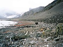
Verila Glacier on Livingston Island in the South Shetland Islands, Antarctica is situated southeast of southern Etar Snowfield, southwest of Berkovitsa and Tundzha Glaciers, and west of Kamchiya Glacier. It is bounded by Rotch Dome to the west, Casanovas Peak and Snow Peak to the north, and Ustra Peak to the southeast. The glacier is roughly crescent-shaped, extending 7 nautical miles in an east-west direction and 2 nautical miles in a north-south direction, and drains southwards into Walker Bay, Bransfield Strait between John Beach and Liverpool Beach at Hannah Point. The glacier's bedrock is connected to Kaliman Island in Walker Bay by a 600 m long moraine tombolo. The area was visited by 19th century British and American sealers.
Yambol Peak is a rocky peak rising to 300 m in the south extremity of Friesland Ridge, Tangra Mountains on Livingston Island in the South Shetland Islands, Antarctica and overlooking Tarnovo Ice Piedmont to the west and Prespa Glacier to the northeast. The ice-free surface area of the peak is 33 hectares. A southeastern offshoot of the peak forms Gela Point. The feature is named after the Bulgarian town of Yambol.
Yavorov Peak is an ice-covered peak of elevation 640 m in the Delchev Ridge of the Tangra Mountains on eastern Livingston Island in the South Shetland Islands, Antarctica. The peak surmounts Sopot Ice Piedmont to the north and west, and Strandzha Glacier to the southeast. The feature was named after the famous Bulgarian poet Peyo Yavorov (1878–1914).

Zagore Beach faces False Bay on Livingston Island, Antarctica and extends for 4 km on the Rozhen Peninsula between Charity Glacier and the Ruen Icefall. The beach is surmounted by Canetti Peak and MacKay Peak. Surface area 220 hectares.

Desolation Island is one of the minor islands in the South Shetlands archipelago, Antarctica situated at the entrance to Hero Bay, Livingston Island. The island is V-shaped with its northern coast indented by Kozma Cove. Surface area is 3.12 square kilometres (1.20 sq mi).

Maglizh Rocks are a group of rocks off the northwest coast of Smith Island, South Shetland Islands. The two adjacent principal rocks, extending 460 m (503 yd) in east-west direction and 140 m (153 yd) wide are situated 300 m (328 yd) north of Lista Point, with the third major one, 300 by 100 m, situated 320 m (350 yd) northwest of them. The rocks have a combined surface area of 10.6 hectares. The rocks are named after the town of Maglizh in southern Bulgaria.
Ereby Point is a point lying 4.5 miles (7.2 km) east-northeast of Hannah Point along the north side of South Bay, Livingston Island in the South Shetland Islands, Antarctica. The name "Erebys Bay" was applied to South Bay on an 1825 chart by James Weddell, "Ereby Point" was applied by the UK Antarctic Place-names Committee in 1961 in order to preserve Weddell's name in the area.
Yana Point is the point forming the west side of the entrance to Bruix Cove in eastern Livingston Island in the South Shetland Islands, Antarctica. The point separates the glacier termini of Huron Glacier to the northwest and Iskar Glacier to the southeast. The feature is named after the settlement of Yana in western Bulgaria.

Window Island is a small ice-free island off the north coast of Ray Promontory in the northwest of Byers Peninsula, Livingston Island in the South Shetland Islands, Antarctica. The island has a surface area of 23 hectares and rises to 72 m (236 ft). It was known to the early 19th century sealers operating on Byers Peninsula.

Station P was a British base camp at the head of Mateev Cove on the east side of Hannah Point, Livingston Island in the South Shetland Islands, Antarctica that supported survey, geology and biology field work from 29 December 1957 until 15 March 1958. The camp was occupied by a six-member team led by Hugh Simpson. The surveyed areas included parts of Byers Peninsula, Elephant Point, Ioannes Paulus II Peninsula and Hurd Peninsula.
Yasen Point is the sharp, rocky point on the south coast of Livingston Island in the South Shetland Islands, Antarctica, forming the west side of the entrance to Mateev Cove. Situated on the east side of the small ice-free promontory ending in Hannah Point to the west.

Zverino Island is the largest and westernmost island in the Meade group lying in the north entrance to McFarlane Strait in the South Shetland Islands, Antarctica. It is extending 1.2 km (0.75 mi) by 700 m (2,300 ft), with surface area of 48 hectares, and is snow-free in summer.


