Ereby Point

Last updated
Location of Livingston Island in the South Shetland Islands. Livingston-Island-location-map.png
Location of Livingston Island in the South Shetland Islands.
Emona Anchorage from Lyaskovets Peak, with Ereby Point on the left. Pimpirev-Beach.jpg
Emona Anchorage from Lyaskovets Peak, with Ereby Point on the left.
Topographic map of Livingston Island. Livingston-Island-Map-2010-15.png
Topographic map of Livingston Island.

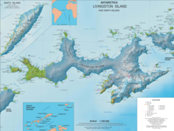
Ereby Point ( 62°38′S60°27′W / 62.633°S 60.450°W / -62.633; -60.450 Coordinates: 62°38′S60°27′W / 62.633°S 60.450°W / -62.633; -60.450 ) is a point lying 4.5 miles (7.2 km) east-northeast of Hannah Point along the north side of South Bay, Livingston Island in the South Shetland Islands, Antarctica. The name "Erebys Bay" was applied to South Bay on an 1825 chart by James Weddell, "Ereby Point" was applied by the UK Antarctic Place-names Committee in 1961 in order to preserve Weddell's name in the area. [1]

Geographic coordinate system Coordinate system

A geographic coordinate system is a coordinate system that enables every location on Earth to be specified by a set of numbers, letters or symbols. The coordinates are often chosen such that one of the numbers represents a vertical position and two or three of the numbers represent a horizontal position; alternatively, a geographic position may be expressed in a combined three-dimensional Cartesian vector. A common choice of coordinates is latitude, longitude and elevation. To specify a location on a plane requires a map projection.

Hannah Point

Hannah Point is a point on the south coast of Livingston Island in the South Shetland Islands, Antarctica. It forms the east side of the entrance to Walker Bay and the west side of the entrance to South Bay. Surmounted by Ustra Peak to the north, with Liverpool Beach extending between the peak and the tip of Hannah Point. Ice-free area ca. 122 hectares.

South Bay (Livingston Island) bay on Livingston Island in the South Shetland Islands, Antarctica

South Bay is a 11.6 kilometres (7.2 mi) wide bay indenting for 12.5 kilometres (7.8 mi) the south coast of Livingston Island in the South Shetland Islands, Antarctica. The bay is lying northwest of False Bay and east of Walker Bay, and is entered between Hannah Point and Miers Bluff. The glaciers Kamchiya, Pimpirev, Perunika, Contell, Johnsons and Hurd Ice Cap feed the bay.

Maps

International Standard Book Number Unique numeric book identifier

The International Standard Book Number (ISBN) is a numeric commercial book identifier which is intended to be unique. Publishers purchase ISBNs from an affiliate of the International ISBN Agency.

Related Research Articles

Rugged Island (South Shetland Islands) island of the South Shetland Islands

Rugged Island is an island 3 miles (4.8 km) long and 1 mile (1.6 km) wide, lying west of Livingston Island in the South Shetland Islands. Its surface area is 10.4 square kilometres (4.0 sq mi). The island's summit San Stefano Peak rises to 256 metres (840 ft) above sea level. Rugged Island is located at 62°38′S61°15′W. Rugged Island was known to both American and British sealers as early as 1820, and the name has been well established in international usage for over 100 years.

Kamchiya Glacier glacier in Antarctica

Kamchiya Glacier is located on Livingston Island in the South Shetland Islands, Antarctica situated south of the glacial divide between the Drake Passage and Bransfield Strait, and south of Tundzha Glacier, west-southwest of Pimpirev Glacier and east of Verila Glacier. The glacier extends 5 km along an east–west axis and is 2.2 km wide, draining into South Bay between Ereby Point and Memorable Beach.

Pimpirev Glacier glacier in Antarctica

Pimpirev Glacier on Livingston Island in the South Shetland Islands, Antarctica is situated south of the glacial divide between the Drake Passage and Bransfield Strait, southeast of Tundzha Glacier, southwest of Saedinenie Snowfield, west of Perunika Glacier and east-northeast of Kamchiya Glacier. The feature extends 5.5 km in a southeast-northwest direction, and 1.8 km in northwest-southeast direction. The glacier drains southeastwards towards Pimpirev Beach, mostly terminating on the shore, and on several occasions penetrating the South Bay waters east-northeast of Ereby Point.

Rongel Reef landform

Rongel Reef, is a moraine reef in the Emona Anchorage in the eastern parts of Livingston Island in the South Shetland Islands, Antarctica. The reef emerged during a glacier retreat in the late 20th and early 21st centuries.

Smolyan Point

Smolyan Point is located on the north-western coast of South Bay, Livingston Island in the South Shetland Islands, Antarctica forming the northwest side of the entrance to Emona Anchorage. The ice-covered point shows conspicuous radial crevasses spreading inland and ends up with a 25 m wide and 4 m high rock. The feature was formed as a result of Pimpirev Glacier's retreat in the late 20th century.

Tundzha Glacier glacier in Antarctica

Tundzha Glacier is a glacier on Livingston Island in the South Shetland Islands, Antarctica situated east-southeast of Berkovitsa Glacier, west of Saedinenie Snowfield, northwest of Pimpirev Glacier, north of Kamchiya Glacier and east-northeast of Verila Glacier. It is bounded by Snow Peak to the west, Teres Ridge to the east and the glacial divide between the Drake Passage and Bransfield Strait to the south. The glacier extends 7.5 nautical miles in east-west direction and 2.4 nautical miles in the north-south direction, and drains northwards into Hero Bay between Avitohol Point and Siddins Point.

Desolation Island (South Shetland Islands)

Desolation Island is one of the minor islands in the South Shetlands archipelago, Antarctica situated at the entrance to Hero Bay, Livingston Island. The island is V-shaped with its northern coast indented by Kozma Cove. Surface area 3.12 square kilometres (1.20 sq mi).

Ballester Point

Ballester Point is a point forming the south side of the entrance to Johnsons Dock and the northeast side of the entrance to Española Cove in Hurd Peninsula, Livingston Island in the South Shetland Islands, Antarctica. The area was visited by early 19th century sealers operating from Johnsons Dock.

Hero Bay Bay of the South Shetland Islands

.

Walker Bay (Livingston Island)

Walker Bay is a bay lying between John Beach and Hannah Point along the south coast of Livingston Island in the South Shetland Islands, Antarctica. The bay is fed by Verila Glacier.

Barclay Bay

Barclay Bay is a bay in Drake Passage lying between Cape Shirreff and Essex Point on the north side of Livingston Island, in the South Shetland Islands. Its head is fed by Etar Snowfield. The name appears on an 1825 chart of the British sealing expedition under James Weddell, and is now established in international usage.

Juan Carlos I Antarctic Base Antarctic base in Spain

Juan Carlos I Antarctic Base, named after the king of Spain, Juan Carlos I, is a seasonal scientific station operated by Spain, opened in January 1988. Situated on Hurd Peninsula, Livingston Island in the South Shetland Islands, Antarctica.

Duff Point

Duff Point is a point on Archar Peninsula forming the western extremity of Greenwich Island, in the South Shetland Islands, Antarctica. The name Duffs Straits was applied to McFarlane Strait by James Weddell in 1820–23, after Captain Norwich Duff under whom Weddell served in HMS Espoir in 1814. The name Duff Point was given by the UK Antarctic Place-Names Committee in 1961 in order to preserve Weddell's name in the area; this point forms the northeast entrance to McFarlane Strait.

Lister Cove cove

Lister Cove is a 2.1 km wide cove indenting for 1.55 km the northeast coast of Varna Peninsula, Livingston Island in the South Shetland Islands, Antarctica south of Pomorie Point and north of Karavelova Point. The cove is fed by Rose Valley Glacier.

Polish Bluff

Polish Bluff is a point forming the southwest side of the entrance to Española Cove and the northeast side of the entrance to Argentina Cove in Hurd Peninsula, Livingston Island in the South Shetland Islands, Antarctica. The area was visited by early 19th century sealers operating from nearby Johnsons Dock.

Henry Bluff

Henry Bluff is a point forming the southwest side of the entrance to Argentina Cove and the north side of the entrance to Las Palmas Cove in Hurd Peninsula, Livingston Island in the South Shetland Islands, Antarctica. The point is dominated by a prominent monolithic formation rising to 163 m and named El Peñón by personnel of the nearby Spanish Antarctic Base. The area was visited by early 19th century sealers operating from nearby Johnsons Dock.

Sally Rocks

Sally Rocks is a small group of rocks trending southwestwards in South Bay just off the west coast of Hurd Peninsula, Livingston Island in the South Shetland Islands, Antarctica.

Yasen Point

Yasen Point is the sharp, rocky point on the south coast of Livingston Island in the South Shetland Islands, Antarctica, forming the west side of the entrance to Mateev Cove. Situated on the east side of the small ice-free promontory ending in Hannah Point to the west.

Atanasova Point

Atanasova Point is the ice-free tipped point on the north coast of Livingston Island projecting 450 m northwards into Hero Bay. It is named after Tsvetelina Atanasova (1960-2018), participant in the Bulgarian Antarctic campaigns in 2009/10 and subsequent seasons.

References

PD-icon.svg This article incorporates  public domain material from the United States Geological Survey document "Ereby Point" (content from the Geographic Names Information System ).

United States Geological Survey Scientific agency of the United States government

The United States Geological Survey is a scientific agency of the United States government. The scientists of the USGS study the landscape of the United States, its natural resources, and the natural hazards that threaten it. The organization has four major science disciplines, concerning biology, geography, geology, and hydrology. The USGS is a fact-finding research organization with no regulatory responsibility.

Geographic Names Information System geographical database

The Geographic Names Information System (GNIS) is a database that contains name and locative information about more than two million physical and cultural features located throughout the United States of America and its territories. It is a type of gazetteer. GNIS was developed by the United States Geological Survey in cooperation with the United States Board on Geographic Names (BGN) to promote the standardization of feature names.