
Sir Ernest Henry Shackleton was an Anglo-Irish Antarctic explorer who led three British expeditions to the Antarctic. He was one of the principal figures of the period known as the Heroic Age of Antarctic Exploration.

Grytviken was the largest whaling station on South Georgia, part of the British Overseas Territory of South Georgia and the South Sandwich Islands in the South Atlantic. The settlement, which is located at the head of King Edward Cove within the larger Cumberland East Bay, was considered the best harbour on South Georgia Island. It was founded on November 16, 1904, by Carl Anton Larsen of Sandefjord, Norway.

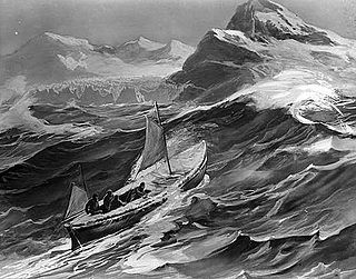
The voyage of the James Caird was a journey of 1,300 kilometres (800 mi) from Elephant Island in the South Shetland Islands through the Southern Ocean to South Georgia, undertaken by Sir Ernest Shackleton and five companions to obtain rescue for the main body of the stranded Imperial Trans-Antarctic Expedition of 1914–1917. Polar historians regard the voyage of the crew in a 22.5' lifeboat through the "Furious Fifties" as one of the greatest small-boat journeys ever completed.

Fortuna Glacier is a tidewater glacier at the mouth of Cumberland Bay on the island of South Georgia. It flows in a northeast direction to its terminus just west of Cape Best, with an eastern distributary almost reaching the west side of Fortuna Bay, on the north coast of South Georgia. It was named in about 1912, presumably after the whale catcher Fortuna, and is notable for two major events in the 20th Century.

The Imperial Trans-Antarctic expedition of 1914–1917 is considered to be the last major expedition of the Heroic Age of Antarctic Exploration. Conceived by Sir Ernest Shackleton, the expedition was an attempt to make the first land crossing of the Antarctic continent. After Amundsen's South Pole expedition in 1911, this crossing remained, in Shackleton's words, the "one great main object of Antarctic journeyings". The expedition failed to accomplish this objective, but became recognized instead as an epic feat of endurance.

Stromness is a former whaling station on the northern coast of South Georgia Island in the South Atlantic. It was the destination of Sir Ernest Shackleton's rescue journey in 1916. It is the central of three harbours in the west side of Stromness Bay, South Georgia.
Henry McNish, often referred to as Harry McNeish or by the nickname Chippy, was the carpenter on Sir Ernest Shackleton's Imperial Trans-Antarctic Expedition of 1914–1917. He was responsible for much of the work that ensured the crew's survival after their ship, the Endurance, was destroyed when it became trapped in pack ice in the Weddell Sea. He modified the small boat, James Caird, that allowed Shackleton and five men to make a voyage of hundreds of miles to fetch help for the rest of the crew.

King Haakon Bay, or King Haakon Sound, is an inlet on the southern coast of the island of South Georgia. The inlet is approximately eight miles (13 km) long and two point five miles (4 km) wide. The inlet was named for King Haakon VII of Norway by Carl Anton Larsen, founder of Grytviken. Queen Maud Bay, named for his queen, is nearby.

Possession Bay is a bay 2 miles (3.2 km) wide on the north coast of South Georgia, an island in the southern Atlantic Ocean. It recedes southwest for 5 miles (8 km), and is separated from Cook Bay to the north by Black Head promontory. It is connected to King Haakon Bay by Shackleton Gap, a mountain pass.

King Edward Cove is a sheltered cove in the west side of Cumberland East Bay, South Georgia. This cove and its surrounding features, frequented by early sealers at South Georgia, was charted by the Swedish Antarctic Expedition, 1901–04, under Otto Nordenskiöld who named it Grytviken. That name, meaning 'Pot Bay,' was subsequently assumed by the whaling station and settlement built in 1904. The cove got its present name in about 1906 for King Edward VII of the United Kingdom.

Crean Glacier is a glacier 4 miles (6.4 km) long, flowing northwest from Wilckens Peaks to the head of Antarctic Bay on the north coast of South Georgia. It was surveyed by the South Georgia Survey in the period 1951–57 and named by the UK Antarctic Place-Names Committee for Irishman Tom Crean, Second Officer of the Endurance during the British expedition under Ernest Shackleton, 1914–16. Crean accompanied Shackleton and Frank Worsley in the James Caird from Elephant Island to King Haakon Bay, South Georgia, and made the overland crossing with them to Stromness; this glacier lies on the route.
Cape Royds is a dark rock cape forming the western extremity of Ross Island, facing on McMurdo Sound, Antarctica. It was discovered by the Discovery Expedition (1901–1904) and named for Lieutenant Charles Royds, Royal Navy, who acted as meteorologist on the expedition. Royds subsequently rose to become an Admiral and was later Commissioner of the Metropolitan Police, London. There is a hut at Cape Royds built and used by Ernest Shackleton and his team during their 1907–1909 expedition.
Mount Worsley is a mountain, 1,105 m, on the west side of Briggs Glacier in South Georgia. It was surveyed by the South Georgia Survey in the period 1951–57, and named by the United Kingdom Antarctic Place-Names Committee (UK-APC) for Frank Arthur Worsley (1872–1943), skipper of the Endurance on 1914-16 Imperial Trans-Antarctic Expedition. Worsley accompanied Ernest Shackleton in the James Caird from Elephant Island to King Haakon Bay, South Georgia, and made the overland crossing with him to Stromness whaling station.
Cave Cove is a small cove located in King Haakon Bay, South Georgia. It is best known for its connection to Ernest Shackleton's Imperial Trans-Antarctic Expedition. It was where the James Caird landed on 10 May 1916, after its tumultuous voyage from Elephant Island. The voyage is commemorated by a small plaque in the rock.
Shackleton Gap is an ice-covered pass rising to about 300 m between King Haakon Bay and Possession Bay, South Georgia. The name Shackletons Pass, after Sir Ernest Shackleton, was used on a map in his book the route across South Georgia used by the Shackleton party in 1916. The form approved was recommended by the United Kingdom Antarctic Place-Names Committee (UK-APC) in 1957.
Shackleton Valley is a broad valley running west-northwest from Stromness Harbor, Stromness Bay, in South Georgia. It was named by the United Kingdom Antarctic Place-Names Committee (UK-APC) after Sir Ernest Henry Shackleton, British Antarctic explorer, whose epic traverse of South Georgia with two of his men, in May 1916, following their boat journey from Elephant Island, ended in this valley. They made contact with Mr. Sorlle, the manager at Stromness whaling station, and then set about organizing the rescue of three of their party from King Haakon Bay, South Georgia, and a further group of men marooned on Elephant Island.
McCarthy Island is an island, 1 nautical mile (2 km) long, lying in the entrance to King Haakon Bay on the south side of South Georgia. It was surveyed by the South Georgia Survey in the period 1951–57, and was named by the UK Antarctic Place-Names Committee after Timothy McCarthy, a seaman on the Endurance during the British expedition under Ernest Shackleton, 1914–16. McCarthy accompanied Shackleton in the James Caird from Elephant Island to King Haakon Bay.
Mount Macklin is a mountain having 2 peaks, the higher at 1,900 metres (6,200 ft), between Mount Carse and Douglas Crag in the southern part of the Salvesen Range of South Georgia. It was surveyed by the South Georgia Survey in the period 1951–57, and was named by the UK Antarctic Place-Names Committee for Alexander H. Macklin, the medical officer of the Imperial Trans-Antarctic Expedition under Ernest Shackleton, 1914–16. Macklin accompanied Shackleton in the voyage of the James Caird from Elephant Island to King Haakon Bay, South Georgia.
Vincent Islands is a small group of islands at the head of King Haakon Bay on the south side of South Georgia. Roughly charted by the British expedition under Shackleton, 1914–16, and surveyed by the SGS in the period 1951–57. Named by the United Kingdom Antarctic Place-Names Committee (UK-APC) for J. Vincent, boatswain of the Endurance, 1914–16, who accompanied Shackleton in the James Caird from Elephant Island to King Haakon Bay.

Timothy 'Tim' McCarthy was an Irish able seaman (AB). He is best known for his service in the Imperial Trans-Antarctic Expedition of 1914–1916, for which he was awarded the Bronze Polar Medal.

