
Signy Island is a small subantarctic island in the South Orkney Islands of Antarctica. It was named by the Norwegian whaler Petter Sørlle (1884–1933) after his wife, Signy Therese.

Thurston Island is a largely ice-covered, glacially dissected island, 135 nautical miles long and 55 nautical miles wide, lying between Amundsen Sea and Bellingshausen Sea a short way off the northwest end of Ellsworth Land, Antarctica. The island is separated from the mainland by Peacock Sound, which is occupied by the west portion of Abbot Ice Shelf.

Tower Island is an Antarctic island 9 kilometres (5 nmi) long and 305 m (1,001 ft) high. It marks the north-east extent of Palmer Archipelago. It lies 37 kilometres (20 nmi) north-east of Trinity Island, separated by Gilbert Strait. Both islands are separated from the Davis Coast to the south by Orléans Strait, running northeast–southwest. The Pearl Rocks lie off the West Coast of Tower Island.

Adelaide Island is a large, mainly ice-covered island, 139 kilometres (75 nmi) long and 37 kilometres (20 nmi) wide, lying at the north side of Marguerite Bay off the west coast of the Antarctic Peninsula. The Ginger Islands lie off the southern end. Mount Bodys is the easternmost mountain on Adelaide Island, rising to over 1,220 m. The island lies within the Argentine, British and Chilean Antarctic claims.

Coronation Island is the largest of the South Orkney Islands, 25 nautical miles (46 km) long and from 3 to 8 nautical miles wide. The island extends in a general east–west direction, is mainly ice-covered and comprises numerous bays, glaciers and peaks, the highest rising to 1,265 metres (4,150 ft).
Trinity Island or Île de la Trinité or Isla Trinidad is an island 24 km (15 mi) long and 10 km (6 mi) wide in the northern part of the Palmer Archipelago, Antarctica. It lies 37 km (23 mi) east of Hoseason Island, 72.6 km (45 mi) south of Deception Island in the South Shetland Islands, and 10.3 km (6 mi) north-northwest of Cape Andreas on the Antarctic Peninsula. The island was named by Otto Nordenskiöld, leader of the 1901-1904 Swedish Antarctic Expedition (SAE) in commemoration of Edward Bransfield's "Trinity Land" of 1820.

Arrowsmith Peninsula is a cape about 40 miles (64 km) long on the west coast of Graham Land, west of Forel Glacier, Sharp Glacier and Lallemand Fjord, and northwest of Bourgeois Fjord, with Hanusse Bay lying to the northwest. It was surveyed by the Falkland Islands Dependencies Survey (FIDS) in 1955-58 and named for Edwin Porter Arrowsmith, Governor of the Falkland Islands.

The Willis Islands are a small archipelago to the west of South Georgia Island in the South Georgia Islands. They are 2 miles (3.2 km) west of Bird Island, separated by the Stewart Strait. They were discovered on 14 January 1775 by Captain James Cook and named for Cook's midshipman Thomas Willis, the crew member who first sighted them. The Willis Islands were charted in greater detail and individually named by Discovery Investigations (DI) personnel between 1926 and 1930.

Thatcher Peninsula is a mountainous peninsula in north-central South Georgia. Its total area is approximately 5,640 hectares, with roughly 1,620 ha covered in vegetation. It terminates to the north in Mai Point, rising between Cumberland West Bay to the west, and Cumberland East Bay and Moraine Fjord to the east. It is bounded to the southwest and south by Lyell Glacier and Hamberg Glacier. King Edward Cove on the east side of the peninsula is the site of the British Antarctic Survey (BAS) Grytviken station and the disused whaling station of the same name.

Barff Peninsula is a peninsula forming the east margin of Cumberland East Bay, South Georgia Island. It is 8 miles (13 km) long and extends northwest from Sörling Valley to Barff Point, its farthest extremity. It was probably first seen by the British expedition under James Cook in 1775. The peninsula as a whole takes its name from Barff Point, which was named for Royal Navy Lieutenant A.D. Barff of HMS Sappho, who, assisted by Captain C.A. Larsen, sketched a map of Cumberland Bay in 1906. Barff Point is considered the eastern headland of East Cumberland Bay.
Fortuna Bay is a bay 3 miles (5 km) long and 1 mile (1.6 km) wide. Its entrance is defined by Cape Best on the west and Robertson Point to the east, near Atherton Peak on the north coast of South Georgia. It was named after the Fortuna, one of the ships of the Norwegian–Argentine whaling expedition under C.A. Larsen which participated in establishing the first permanent whaling station at Grytviken, South Georgia, in 1904–05. The Second German Antarctic Expedition (SGAE) under Wilhelm Filchner explored Fortuna Bay in 1911–12. Discovery Investigations (DI) personnel charted the area during their 1929–30 expedition.

Cape Buller is a rugged headland forming the west side of the entrance to the Bay of Isles on the north coast of South Georgia. It was discovered and named in 1775 by a British expedition under James Cook.
Right Whale Bay is a bay 1.5 miles (2.4 km) wide, entered between Craigie Point and Nameless Point along the north coast of South Georgia Island. The bay is named for the southern right whales found in the area. South Georgia has historically been well known for whaling. The bay is linked to Morsa Bay on the island's south coast by a mountain pass called Ernesto Pass.
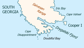
Drygalski Fjord is a bay 1 mile (1.6 km) wide which recedes northwestwards 7 miles (11 km), entered immediately north of Nattriss Head along the southeast coast of South Georgia. It was charted by the Second German Antarctic Expedition, 1911–12, under Wilhelm Filchner, and named for Professor Erich von Drygalski, the leader of the First German Antarctica Expedition, 1901–03.

The Bay of Isles is a bay 9 miles (14 km) wide and receding 3 miles (5 km), lying between Cape Buller and Cape Wilson along the north coast of South Georgia. It was discovered in 1775 by a British expedition under James Cook and so named by him because numerous islands lie in the bay. Of South Georgia's 31 breeding bird species, 17 are found here.
Elsehul is a bay along the north coast of South Georgia Island in the southern Atlantic Ocean. Elsehul is approximately 0.5 miles (0.8 km) wide, and is separated from nearby Undine Harbour by the narrow Survey Isthmus. The name "Elsehul" dates back to the period 1905–12 and was probably applied by Norwegian sealers and whalers working in the area. The Discovery Investigations (DI) expedition of 1930 surveyed Elsehul and the surrounding area, naming many features. A British Admiralty chart dating to 1931 provided the first instance of many other names; unless otherwise specified, features noted in this article were first named on this chart.

Clark Peninsula is a rocky peninsula, about 3 km (2 mi) long and wide, lying 5 km (3 mi) north-east of Australia's Casey Station at the north side of Newcomb Bay on the Budd Coast of Wilkes Land in Antarctica.
Buchanan Point is a headland 5 km (3.1 mi) north-west of Cape Dundas and 2 km (1.2 mi) south-east of Mackintosh Cove, at the north-eastern end of Laurie Island in the South Orkney Islands of Antarctica.
Diaz Cove is a cove with the Kupriyanov Islands at the mouth, 10 nautical miles (19 km) northwest of Cape Disappointment, near the east end of the south coast of South Georgia. The cove was known to early sealers as shown by the remains of a sealing vessel found there. It was rediscovered in 1929 by Captain Johannesen and named for his ship the Diaz.

New Harbour is a bay about 10 nautical miles wide between Cape Bernacchi and Butter Point along the coast of Victoria Land, due west of Ross Island.
