Thatcher Peninsula

Last updated

Location of Thatcher Peninsula Thatcher Peninsula - South Georgia.svg
Location of Thatcher Peninsula
Location map South Georgia.png
Red pog.svg
Thatcher Peninsula
Thatcher Peninsula within South Georgia
Central South Georgia: Cumberland Bay; Thatcher Peninsula with King Edward Cove (Grytviken) in the lower center; Allardyce Range with the summit Mt. Paget (NASA imagery). Thatcher-Peninsula.jpg
Central South Georgia: Cumberland Bay; Thatcher Peninsula with King Edward Cove (Grytviken) in the lower center; Allardyce Range with the summit Mt. Paget (NASA imagery).

Thatcher Peninsula ( 54°17′S36°32′W / 54.283°S 36.533°W / -54.283; -36.533 ) is a mountainous peninsula in north-central South Georgia. Its total area is approximately 5,640 hectares (13,900 acres), with roughly 1,620 ha (4,000 acres) covered in vegetation. [1] It terminates to the north in Mai Point, rising between Cumberland West Bay to the west, and Cumberland East Bay and Moraine Fjord to the east. It is bounded to the southwest and south by Lyell Glacier and Hamberg Glacier. King Edward Cove on the east side of the peninsula is the site of the British Antarctic Survey (BAS) Grytviken station and the disused whaling station of the same name. [2]

Contents

Thatcher Peninsula was named by the United Kingdom Antarctic Place-Names Committee (UK-APC) in 1991, at the suggestion of members of the Royal Geographical Society, after Margaret Thatcher, British prime minister, 1979–90. She was described by Sir Vivian Fuchs, chair of the Foreign Office's Antarctic Place Names Committee, as 'a major figure in the history of South Georgia', for her role in the Falklands War. [3] [4] Thatcher was, according to friends, "flattered and amused" by the honour. [3]

Geography

Maiviken Maiviken.jpg
Maiviken

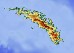
Many features on the coast of the peninsula have been individually charted and named. Features on the west coast are detailed as part of Cumberland West Bay, and those on the east coast are detailed as part of Cumberland East Bay.

Northern coast

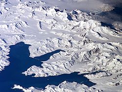
The most prominent feature on the northern coast of the peninsula is Maiviken, a small cove. Maiviken and its surrounding features were first charted by the Swedish Antarctic Expedition (SAE), 1901–04, under Otto Nordenskjold. Maiviken was first entered on May Day, 1902, and was therefore named "Majviken" (May Cove). Over the years, the Norwegian spelling Maiviken has become established for the cove. [5]

Poa Cove is a smaller cove that indents the southeast corner of Maiviken. [6] Burnet Cove indents the northeastern coast of Maiviken, southwest of Mai Point. [7] Close south of Mai Point is Tortula Cove. These three smaller coves were resurveyed by Discovery Investigations (DI) personnel in 1929 and the Falkland Islands Dependencies Survey (FIDS) in 1951. All three were named by UK-APC for plant genera common in their vicinity; Poa for the grass genus Poa , Burnet for the common name of genus Acaena , and Tortula for the moss genus Tortula . [6] [7] [8] Mai Point marks the eastern side of Maiviken, as well as the northernmost extent of the peninsula as a whole. Its name was given by SAE personnel in association with Maiviken. [9]

East of Mai Point, Sappho Point marks the west side of the entrance to Cumberland East Bay, on the north coast of South Georgia. Probably first sighted by the 1775 British expedition under Captain James Cook which explored the north coast of South Georgia. Named for HMS Sappho, a British ship used in charting portions of Cumberland Bay in 1906. [10]

Inland features

On the northern portion of the peninsula, Camp Peak rises to about 1,080 ft (330 m) on the west side of Maiviken. It was charted by DI in 1929 and so named because a camp was established on the shore below the peak. [11]

Spencer Peak rises to 1,457 ft (444 m) tall southwest of Sappho Point. The name appears to be first used on a 1906 British Admiralty chart and is probably for Lieutenant P. Spencer, who surveyed in Cumberland Bay from HMS Sappho in 1906. [12] Northwest of Spencer Peak, the valley Maidalen runs north-south down to Lewis Pass. [13] Mount Duse stands 505 metres (1,660 ft) high, approximately 0.86 nmi (1.6 km) south of Spencer Peak surmounting King Edward Point. It was charted in 1902 by Lieutenant S.A. Duse, cartographer of the SAE, for whom it is named. [14] Mount Hodges stands 605 metres (1,985 ft) high, 1 nmi (2 km) west of Mount Duse. It first appears as "Moldaenke Berg" on a 1907 map by A. Szielasko, but this name was supplanted by "Mount Hodges", which appears to have been applied some years later and is now well established. It was probably named for Captain M.H. Hodges, Royal Navy, of the Sappho, who visited and mapped portions of Cumberland Bay in 1906. [15]

Several freshwater lakes and ponds are located along the east and southeast shores of Maiviken, all named by UK-APC. Løken Pond is the northernmost of these, found east of Burnet Cove. It was named after Reverend Kristen Løken, a Norwegian Lutheran minister from Lillehammer, the first appointed pastor of South Georgia. [16] Arch Pond, named for a nearby natural arch, lies slightly south, between Burnet and Poa coves. [17] East of Arch Pond is shallow Humic Lake, named for the dark-stained water caused by humic acid derived from the leaching of decaying peat on nearby slopes. [18] Southernmost of this small group is Evans Lake, a comparatively deep lake of irregular shape named after John C. Ellis-Evans, a BAS biologist. [19]

South of the head of Maiviken is the lake Maivatn. It is the largest, and at 39 metres (128 ft) deep, also the deepest of the small freshwater lakes in the Maiviken area. The lake was named Maivatn (May lake) in association with Maiviken. [20] Tiny Lancetes Lake is found to the southwest of it. [21]

Wildlife

A South Georgia pipit on South Georgia island. Anthus antarcticus -South Georgia, British overseas territory-8.jpg
A South Georgia pipit on South Georgia island.

Lancetes Lake has a rich benthic flora of algae and mosses, which support a large population of the only water beetle seen in the sub-Antarctic, Lancetes clausii , from which the feature takes its name. [21]

Brown rats are considered an invasive species on Thatcher Peninsula. [1] They threaten the survival of native species such as the South Georgia pipit. [22] From approximately 2011 to 2014, the government of South Georgia and the South Sandwich Islands undertook efforts to eradicate them by air-dropping brodifacoum pellets. [1] Follow-up monitoring a year after the project indicated that the eradication had been a success, with little evidence of rats found. [22]

Related Research Articles

<span class="mw-page-title-main">Signy Island</span> Island of Antarctica

Signy Island is a small subantarctic island in the South Orkney Islands of Antarctica. It was named by the Norwegian whaler Petter Sørlle (1884–1933) after his wife, Signy Therese.

<span class="mw-page-title-main">Tower Island</span> Island in Palmer Archipelago, Antarctica

Tower Island is an Antarctic island 9 kilometres (5 nmi) long and 305 m (1,001 ft) high. It marks the north-east extent of Palmer Archipelago. It lies 37 kilometres (20 nmi) north-east of Trinity Island, separated by Gilbert Strait. Both islands are separated from the Davis Coast to the south by Orléans Strait, running northeast–southwest. The Pearl Rocks lie off the West Coast of Tower Island.

Trinity Island or Île de la Trinité or Isla Trinidad is an island 24 km (15 mi) long and 10 km (6 mi) wide in the northern part of the Palmer Archipelago, Antarctica. It lies 37 km (23 mi) east of Hoseason Island, 72.6 km (45 mi) south of Deception Island in the South Shetland Islands, and 10.3 km (6 mi) north-northwest of Cape Andreas on the Antarctic Peninsula. The island was named by Otto Nordenskiöld, leader of the 1901-1904 Swedish Antarctic Expedition (SAE) in commemoration of Edward Bransfield's "Trinity Land" of 1820.

Queen Maud Bay is a V-shaped bay 2.5 miles (4.0 km) wide at the entrance, lying immediately north of Nuñez Peninsula along the south coast of South Georgia. Roughly charted in 1819 by a Russian expedition under Bellingshausen, it was named prior to 1922 for Queen Maud, wife of King Haakon VII of Norway, probably by Norwegian whalers who frequented this coast.

<span class="mw-page-title-main">King Edward Cove</span> Sheltered cove in the west side of Cumberland East Bay, South Georgia

King Edward Cove is a sheltered cove in the west side of Cumberland East Bay, South Georgia. This cove and its surrounding features, frequented by early sealers at South Georgia, was charted by the Swedish Antarctic Expedition, 1901–04, under Otto Nordenskiöld who named it Grytviken. That name, meaning 'Pot Bay,' was subsequently assumed by the whaling station and settlement built in 1904. The cove got its present name in about 1906 for King Edward VII of the United Kingdom.

<span class="mw-page-title-main">Hound Bay</span>

Hound Bay is a bay at the base of Barff Peninsula. It is 2.5 miles (4 km) wide at its mouth and recedes 3 miles (5 km), entered between Tijuca Point and Cape Vakop along the north coast of South Georgia. The names "George Bay" and "Hundebugten" have appeared on charts for this feature. The South Georgia Survey (SGS) of 1951–52 reported that this bay was better known to whalers and sealers as "Bikjebugten". The name Hound Bay, proposed by the UK Antarctic Place-Names Committee (UK-APC) is an English form of this name.

<span class="mw-page-title-main">Barff Peninsula</span> Peninsula forming the east margin of Cumberland East Bay, South Georgia Island

Barff Peninsula is a peninsula forming the east margin of Cumberland East Bay, South Georgia Island. It is 8 miles (13 km) long and extends northwest from Sörling Valley to Barff Point, its farthest extremity. It was probably first seen by the British expedition under James Cook in 1775. The peninsula as a whole takes its name from Barff Point, which was named for Royal Navy Lieutenant A.D. Barff of HMS Sappho, who, assisted by Captain C.A. Larsen, sketched a map of Cumberland Bay in 1906. Barff Point is considered the eastern headland of East Cumberland Bay.

<span class="mw-page-title-main">Cumberland East Bay</span>

Cumberland East Bay is a bay forming the eastern arm of Cumberland Bay, South Georgia. It is entered between Sappho Point on Thatcher Peninsula and Barff Point on Barff Peninsula. It is nearly 3 miles (4.8 km) wide, and extends 8 miles (13 km) in a southeast direction.

<span class="mw-page-title-main">Cumberland West Bay</span> Body of water in Antarctica

Cumberland West Bay is a bay forming the western arm of Cumberland Bay, South Georgia. It is entered southward of Larsen Point, where it is 2.5 miles (4 km) wide and extends 7 miles (11 km) in a southwest direction. It is separated from Cumberland East Bay by Thatcher Peninsula. Papua Beach is situated on its southeast shore.

<span class="mw-page-title-main">Bay of Isles</span> Bay along the coast of South Georgia

The Bay of Isles is a bay 9 miles (14 km) wide and receding 3 miles (5 km), lying between Cape Buller and Cape Wilson along the north coast of South Georgia. It was discovered in 1775 by a British expedition under James Cook and so named by him because numerous islands lie in the bay. Of South Georgia's 31 breeding bird species, 17 are found here.

Jason Harbour is a bay 1 mile (1.6 km) wide, lying west of Allen Bay in the north side of Cumberland West Bay, South Georgia. It was charted and named by the Swedish Antarctic Expedition, 1901–04, under Otto Nordenskiöld. The bay was previously visited by the Jason, Captain C.A. Larsen, in 1894.

<span class="mw-page-title-main">Greene Peninsula</span> Mountainous peninsula within Cumberland East Bay

Greene Peninsula is a mountainous peninsula within Cumberland East Bay, separating Moraine Fjord to the west from the main arm of Cumberland East Bay, on the north coast of South Georgia Island. The entire area was charted by the Swedish Antarctic Expedition (SAE), 1901–04, under Otto Nordenskjöld. The peninsula was named by the UK Antarctic Place-Names Committee (UK-APC) in 1979 after Stanley Wilson Greene, a British bryologist who worked in South Georgia.

<span class="mw-page-title-main">Moraine Fjord</span> Fjord in South Georgia

Moraine Fjord is an inlet 3.5 nautical miles long with a reef extending across its entrance, forming the west head of Cumberland East Bay, South Georgia. It was charted by the Swedish Antarctic Expedition under Otto Nordenskjöld, 1901–04, who so named it because of the large glacial moraine at its entrance.

Hestesletten is a glacial plain between the Hamberg Lakes and Cumberland East Bay, South Georgia. It is covered with tussock and is almost 2 miles (3.2 km) long in a northeast–southwest direction and 0.75 miles (1.2 km) wide. It is, along with Salisbury Plain, one of the few substantial flat areas on the island.

Sörling Valley is an ice-free valley between Cumberland East Bay and Hound Bay on the north side of South Georgia. Surveyed by the SGS in the period 1951–57. Named by the United Kingdom Antarctic Place-Names Committee (UK-APC) for Erik Sörling of the Riksmuseum, Stockholm, who made zoological collections in South Georgia in 1904–05. Nearby features include Ellerbeck Peak, a mountain on the south side of the valley.

<span class="mw-page-title-main">Busen Point</span> Headland on South Georgia

Busen Point or Busen Peninsula is a headland forming the southeast side of the entrance to Stromness Bay, on the north coast of South Georgia island. It lies on the Lewin Peninsula in between Stromness Bay and Cumberland West Bay.

East Ongul Island is an island in the Flatvaer Islands off of Antarctica. It is 2 kilometres (1 nmi) long, lying immediately east of the northern part of Ongul Island at the east side of the entrance of Lutzow-Holm Bay.

<span class="mw-page-title-main">Clark Peninsula</span> Peninsula of Antarctica

Clark Peninsula is a rocky peninsula, about 3 km (2 mi) long and wide, lying 5 km (3 mi) north-east of Australia's Casey Station at the north side of Newcomb Bay on the Budd Coast of Wilkes Land in Antarctica.

The Langhovde Hills are an extensive area of bare rocky hills along the eastern shore of Lützow-Holm Bay, in Queen Maud Land, Antarctica. They are located just south of Hovde Bay. They were mapped by Norwegian cartographers from aerial photographs taken by the Lars Christensen Expedition (LCE) in 1936–37, and named descriptively Langhovde. Many other features were mapped from surveys and air photos by the Japanese Antarctic Research Expedition (JARE) of 1957–62, and subsequently named by JARE Headquarters.

<span class="mw-page-title-main">Golden Pond, Kentucky</span> Ghost town in Kentucky, United States

Golden Pond was a town in western Trigg County, Kentucky, United States. It is now the site of the headquarters of Land Between the Lakes National Recreation Area, 11 miles (18 km) west-southwest of Cadiz. Golden Pond was established in the 19th century and became known for its moonshining activity during the Prohibition era. This town was in an area altered during the 1930s and later by the Tennessee Valley Authority, which constructed dams to control flooding and generate electricity for a large rural area. The TVA evicted the last residents of Golden Pond in 1969, when the recreation area was established.

References

  1. 1 2 3 Black, Andy; Lee, Jennifer (2014). Post-baiting rat monitoring on the Thatcher Peninsula (PDF) (Report). Government of South Georgia and the South Sandwich Islands. p. 2. Retrieved 14 July 2019.
  2. "Thatcher Peninsula". Geographic Names Information System . United States Geological Survey, United States Department of the Interior . Retrieved 18 May 2019.
  3. 1 2 'Peninsula on South Georgia to be named after Margaret Thatcher', The Times (15 June 1991).
  4. Sam Lister, 'Navy man puts name down for an island', The Times (25 January 2002), p. 6.
  5. "Maiviken". Geographic Names Information System. United States Geological Survey. Retrieved 18 May 2019.
  6. 1 2 "Poa Cove". Geographic Names Information System. United States Geological Survey. Retrieved 18 May 2019.
  7. 1 2 "Burnet Cove". Geographic Names Information System. United States Geological Survey. Retrieved 18 May 2019.
  8. "Tortula Cove". Geographic Names Information System. United States Geological Survey. Retrieved 18 May 2019.
  9. "Mai Point". Geographic Names Information System. United States Geological Survey. Retrieved 18 May 2019.
  10. "Sappho Point". Geographic Names Information System. United States Geological Survey. Retrieved 18 May 2019.
  11. "Camp Peak". Geographic Names Information System. United States Geological Survey. Retrieved 18 May 2019.
  12. "Spencer Peak". Geographic Names Information System. United States Geological Survey. Retrieved 18 May 2019.
  13. "Maidalen". Geographic Names Information System. United States Geological Survey. Retrieved 18 May 2019.
  14. "Mount Duse". Geographic Names Information System. United States Geological Survey. Retrieved 18 May 2019.
  15. "Mount Hodges". Geographic Names Information System. United States Geological Survey. Retrieved 18 May 2019.
  16. "Løken Pond". Geographic Names Information System. United States Geological Survey. Retrieved 18 May 2019.
  17. "Arch Pond". Geographic Names Information System. United States Geological Survey. Retrieved 18 May 2019.
  18. "Humic Lake". Geographic Names Information System. United States Geological Survey. Retrieved 18 May 2019.
  19. "Evans Lake". Geographic Names Information System. United States Geological Survey. Retrieved 18 May 2019.
  20. "Maivatn". Geographic Names Information System. United States Geological Survey. Retrieved 18 May 2019.
  21. 1 2 "Lancetes Lake". Geographic Names Information System. United States Geological Survey. Retrieved 18 May 2019.
  22. 1 2 Black & Lee 2014, p. 5.

PD-icon.svg This article incorporates public domain material from "Thatcher Peninsula". Geographic Names Information System . United States Geological Survey.  OOjs UI icon edit-ltr-progressive.svg