Related Research Articles
Avian Island is an island, 1.2 km (0.7 mi) long and 40 metres (130 ft) high, lying close off the south tip of Adelaide Island, Antarctica. It was discovered by the French Antarctic Expedition, 1908–10, under Jean-Baptiste Charcot, and visited in 1948 by the Falkland Islands Dependencies Survey, who so named it because of the large number and variety of birds (avians) found there.

Flask Glacier, is a gently-sloping glacier, 25 nautical miles long, flowing east from Bruce Plateau to enter Scar Inlet between Daggoo Peak and Spouter Peak in Graham Land, Antarctica. The lower reaches of this glacier were surveyed and photographed by the Falkland Islands Dependencies Survey (FIDS) in 1947. The entire glacier was photographed by the Falkland Islands and Dependencies Aerial Survey Expedition in 1955–56, and mapped by the FIDS in 1957. It was named by the UK Antarctic Place-names Committee after the third mate on the Pequod in Herman Melville's Moby-Dick; or, The White Whale.

Usnea Plug is a volcanic plug, 30 m from base to summit, rising to 117 m in the interior of Byers Peninsula, Livingston Island in the South Shetland Islands, Antarctica. The area was known to 19th century sealers.

Eddystone Rocks is a group of two rocks lying to the northwest of Rugged Island off western Livingston Island in the South Shetland Islands, Antarctica.

The borders of the oceans are the limits of Earth's oceanic waters. The definition and number of oceans can vary depending on the adopted criteria. The principal divisions of the five oceans are the Pacific Ocean, Atlantic Ocean, Indian Ocean, Southern (Antarctic) Ocean, and Arctic Ocean. Smaller regions of the oceans are called seas, gulfs, bays, straits, and other terms. Geologically, an ocean is an area of oceanic crust covered by water.
Planet Heights is a series of summits running along an ice-free ridge, extending 24 nautical miles (44 km) in a north-south direction between the southernmost extremity of the LeMay Range and George VI Sound in the east part of Alexander Island, Antarctica. Many landforms and nearby features are named in association with this mountain range; some of these include landforms named after astronomers, satellites, planets and other things related to astrology and astrophysics. The mountain range was first mapped from air photos taken by the Ronne Antarctic Research Expedition (RARE), 1947–48, by Searle of the Falkland Islands Dependencies Survey (FIDS) in 1960. Named by the United Kingdom Antarctic Place-Names Committee (UK-APC) from association with the nearby glaciers named for planets of the Solar System. The only planet that is not featured in any of these glaciers is the planet Earth, as there are no glaciers named "Earth Glacier" and this glacier does not exist.
The Pointers is a pair of rocks off the northwest coast of Rugged Island, lying between Eddystone Rocks and Start Point, Livingston Island in the South Shetland Islands, Antarctica.
The Edgeworth Glacier is a glacier 12 nautical miles long, flowing south-southwestwards from the edge of Detroit Plateau below Wolseley Buttress to the ice shelf west of Sobral Peninsula, Graham Land, Antarctica.

Cape Lloyd is a cape which forms the north end of Clarence Island in the South Shetland Islands of Antarctica, on the north side of the entrance to Kutela Cove. The name "Lloyd's Promontory" appears on charts of the 1821–1825 period, but in more recent years the feature has become internationally known as Cape Lloyd.
Skaplizo Glacier is 2 nautical miles long and 0.8 nautical miles wide glacier on the west side of Urda Ridge on Clarence Island in the South Shetland Islands, Antarctica situated south of Giridava Glacier. It drains the slopes of Mount Irving and Duclos-Guyot Bluff, flows west-northwestwards and enters the Southern Ocean northeast of Chichil Point.
Dobrodan Glacier is the 3.4 km long and 1.2 km wide glacier on the east side of Urda Ridge on Clarence Island in the South Shetland Islands, Antarctica situated south of Highton Glacier. It drains the slopes of Mount Irving and Duclos-Guyot Bluff, flows northeastwards and enters the Southern Ocean south of Lebed Point.
Bersame Glacier is the 2.4 km long and 1.5 km wide glacier on the west side of Urda Ridge on Clarence Island in the South Shetland Islands, Antarctica situated northeast of Giridava Glacier. It drains the slopes of Mount Llana, flows northwestwards and enters the Southern Ocean northeast of the terminus of Giridava Glacier.
Treskavets Glacier is 1.3 nautical miles long and 0.8 nautical miles wide glacier on the east side of Ravelin Ridge on Clarence Island in the South Shetland Islands, Antarctica situated north of Highton Glacier and south of Orcho Glacier. It drains the slopes of Jerez Peak, flows northeastwards and enters the Southern Ocean south of Gesha Point.
Orcho Glacier is 1.1 nautical miles long and 1 nautical mile wide glacier on the east side of Ravelin Ridge on Clarence Island in the South Shetland Islands, Antarctica situated north of Treskavets Glacier and south-southwest of Banari Glacier. It flows eastwards and enters the Southern Ocean north of Gesha Point.
Banari Glacier is the 1 nautical mile long and 0.6 nautical miles wide glacier on the east side of Ravelin Ridge on Clarence Island in the South Shetland Islands, Antarctica situated north-northeast of Orcho Glacier. It flows northeastwards and enters Smith Cove.
Sugarloaf Island is a conspicuous small island which lies close to the east side of Clarence Island, midway between Cape Lloyd and Cape Bowles, in the South Shetland Islands, Antarctica. It lies 3.2 km north of Lebed Point, on the northern side of the entrance to Istros Bay. The name was in use by American and British sealers as early as 1822 and is now well established.
The Stadium is a cirque with mountains on three sides but open on the east, located 1 mi north of Walker Point on Elephant Island in the South Shetland Islands of Antarctica. The floor of this feature is occupied by a homonymous glacier feeding the head of Gurkovska Cove. Mapped by the U.K. Joint Services Expedition to Elephant Island, 1970–71. UK Antarctic Place-names Committee (UK-APC) applied the descriptive name for this bowl-shaped feature.
Dzhegov Rock is the solitary rock in eastern Prince Charles Strait, South Shetland Islands in Antarctica extending 40 m in southeast-northwest direction and 30 m in southwest-northeast direction. It is “named after Captain Simeon Dzhegov (1938–2011), Director in 1987 of the Bulgarian company Ocean Fisheries – Burgas whose ships operated in the waters of South Georgia, Kerguelen, the South Orkney Islands, South Shetland Islands and Antarctic Peninsula from 1970 to the early 1990s. The Bulgarian fishermen, along with those of the Soviet Union, Poland and East Germany are the pioneers of modern Antarctic fishing industry.”
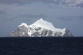
Pinnacle Rock, sometimes named Roca de la Aguja or Pinnacle Island, is a rocky island, rising to 120 m above sea level, in the South Shetland Islands. It lies 2.5 miles (4.0 km) to the east of Point Wild and close to the north coast of Elephant Island, which is partly connected to it by a reef. Its current name, made official in 1952, was probably suggested by members of the British expedition under Shackleton, 1914–16, who sighted and described this feature as a pillar of rock during their refuge at Elephant Island following the loss of the Endurance.
References
- ↑ "Antarctica Detail". 2 June 2021. Archived from the original on 2 June 2021. Retrieved 13 February 2023.
 This article incorporates public domain material from "The Cornet". Geographic Names Information System . United States Geological Survey.
61°7′S54°47′W / 61.117°S 54.783°W
| | This Elephant Island location article is a stub. You can help Wikipedia by expanding it. |