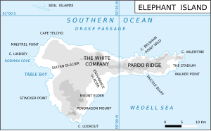
Elephant Island is an ice-covered, mountainous island off the coast of Antarctica in the outer reaches of the South Shetland Islands, in the Southern Ocean. The island is situated 245 kilometres north-northeast of the tip of the Antarctic Peninsula, 1,253 kilometres west-southwest of South Georgia, 935 kilometres south of the Falkland Islands, and 885 kilometres southeast of Cape Horn. It is within the Antarctic claims of Argentina, Chile and the United Kingdom.

Clarence Island is the easternmost island in the South Shetland Islands, off the coast of Antarctica. It is claimed by Argentina as part of Argentine Antarctica, by Britain as part of the British Antarctic Territory, and by Chile as part of the Chilean Antarctic Territory. The name dates back to at least 1820 and is now established in international usage, except for Russia, where it has been known as Shishkova Island since its discovery by the First Russian Antarctic Expedition in 1821.

Cape Yelcho is the northwestern extremity of Elephant Island in the South Shetland Islands of Antarctica. It was named by the UK Joint Services Expedition, 1970–71, after the Chilean steam tug Yelcho.
The Cornet is a peak on the south side of Pardo Ridge between Muckle Bluff and The Stadium. Located on Elephant Island in the South Shetland Islands of Antarctica, it was named descriptively for its conical shape by the UK Joint Services Expedition, 1970-71.

Point Wild is a point 11 km (6.8 mi) west of Cape Valentine, 2 km (1.2 mi) east of Saddleback Point, and directly adjacent to the Furness Glacier on the north coast of Elephant Island. It was named Cape Wild by the Shackleton Endurance expedition 1914–16, but Point Wild is recommended for this feature because of its small size and to avoid confusion with Cape Wild on George V Coast.

Highton Glacier is a glacier on the east coast of Clarence Island in the South Shetland Islands, south of Sugarloaf Island, flowing northeast to the sea. Called "Stamina Glacier" from the stamina needed to cross it by the Joint Services Expedition to the Elephant Island Group, 1976–77, it was named by the UK Antarctic Place-Names Committee in 1980 after Commander John E. Highton, Royal Navy, Deputy Leader of the expedition and in charge of the group on Clarence Island.
Marla Glacier is a glacier 8 nautical miles long and 1 nautical mile wide on the northeast side of Detroit Plateau on the southern Trinity Peninsula in Graham Land, Antarctica.
Urda Ridge is the mostly ice-covered ridge occupying the interior of southern Clarence Island in the South Shetland Islands, Antarctica. It extends 8 km in north-northeast to south-southwest direction and 9 km in west-northwest to east-southeast direction, rising to 1950 m at the island's summit Mount Irving, and is connected to Ravelin Ridge to the north by Soyka Saddle. The southeast slopes of the feature are drained by Dobrodan and Highton Glaciers, and its northwest slopes — by Skaplizo, Giridava and Bersame Glaciers. Urda is a Thracian place name from Southern Bulgaria.
Skaplizo Glacier is 2 nautical miles long and 0.8 nautical miles wide glacier on the west side of Urda Ridge on Clarence Island in the South Shetland Islands, Antarctica situated south of Giridava Glacier. It drains the slopes of Mount Irving and Duclos-Guyot Bluff, flows west-northwestwards and enters the Southern Ocean northeast of Chichil Point.
Dobrodan Glacier is the 3.4 km long and 1.2 km wide glacier on the east side of Urda Ridge on Clarence Island in the South Shetland Islands, Antarctica situated south of Highton Glacier. It drains the slopes of Mount Irving and Duclos-Guyot Bluff, flows northeastwards and enters the Southern Ocean south of Lebed Point.
Giridava Glacier is 1.5 nautical miles long and 0.6 nautical miles wide glacier on the west side of Urda Ridge on Clarence Island in the South Shetland Islands, Antarctica situated north of Skaplizo Glacier and southwest of Bersame Glacier. It drains the slopes of Mount Irving, flows northwestwards and enters Chinstrap Cove east of Vaglen Point.
Bersame Glacier is the 2.4 km long and 1.5 km wide glacier on the west side of Urda Ridge on Clarence Island in the South Shetland Islands, Antarctica situated northeast of Giridava Glacier. It drains the slopes of Mount Llana, flows northwestwards and enters the Southern Ocean northeast of the terminus of Giridava Glacier.
Treskavets Glacier is 1.3 nautical miles long and 0.8 nautical miles wide glacier on the east side of Ravelin Ridge on Clarence Island in the South Shetland Islands, Antarctica situated north of Highton Glacier and south of Orcho Glacier. It drains the slopes of Jerez Peak, flows northeastwards and enters the Southern Ocean south of Gesha Point.
Orcho Glacier is 1.1 nautical miles long and 1 nautical mile wide glacier on the east side of Ravelin Ridge on Clarence Island in the South Shetland Islands, Antarctica situated north of Treskavets Glacier and south-southwest of Banari Glacier. It flows eastwards and enters the Southern Ocean north of Gesha Point.
Banari Glacier is the 1 nautical mile long and 0.6 nautical miles wide glacier on the east side of Ravelin Ridge on Clarence Island in the South Shetland Islands, Antarctica situated north-northeast of Orcho Glacier. It flows northeastwards and enters Smith Cove.
Sugarloaf Island is a conspicuous small island which lies close to the east side of Clarence Island, midway between Cape Lloyd and Cape Bowles, in the South Shetland Islands, Antarctica. It lies 3.2 km north of Lebed Point, on the northern side of the entrance to Istros Bay. The name was in use by American and British sealers as early as 1822 and is now well established.
Dzhegov Rock is the solitary rock in eastern Prince Charles Strait, South Shetland Islands in Antarctica extending 40 m in southeast-northwest direction and 30 m in southwest-northeast direction. It is “named after Captain Simeon Dzhegov (1938–2011), Director in 1987 of the Bulgarian company Ocean Fisheries – Burgas whose ships operated in the waters of South Georgia, Kerguelen, the South Orkney Islands, South Shetland Islands and Antarctic Peninsula from 1970 to the early 1990s. The Bulgarian fishermen, along with those of the Soviet Union, Poland and East Germany are the pioneers of modern Antarctic fishing industry.”
Saffar Island is the rocky island off the north coast of Elephant Island in the South Shetland Islands, Antarctica extending 290 m in west–east direction and 230 m in south–north direction, with a surface area of 3.64 ha. It is separated from Elephant Island by a passage narrowing to 325 m at points.
Biruni Island is the rocky island off the north coast of Elephant Island in the South Shetland Islands, Antarctica 450 m long in southwest–northeast direction and 150 m wide, with a surface area of 3.59 ha. It is separated from Elephant Island by a passage narrowing to 70 m at points. The island was formed as a result of the retreat of Elephant Island's ice cap at the turn of the 21st century.
Snellius Glacier is the glacier extending 7 km in west–east direction and 3 km in south–north direction on the north coast of Elephant Island in the South Shetland Islands, Antarctica draining the north slopes of Pardo Ridge and flowing northwards into Drake Passage between Eratosthenes Point and Ronalds Point. The area was visited by early 19th century sealers.