
Elephant Island is an ice-covered, mountainous island off the coast of Antarctica in the outer reaches of the South Shetland Islands, in the Southern Ocean. The island is situated 245 kilometres north-northeast of the tip of the Antarctic Peninsula, 1,253 kilometres west-southwest of South Georgia, 935 kilometres south of the Falkland Islands, and 885 kilometres southeast of Cape Horn. It is within the Antarctic claims of Argentina, Chile and the United Kingdom.
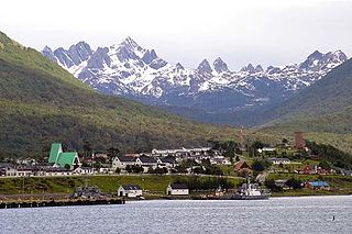
Puerto Williams is the city, port and naval base on Navarino Island in Chile. It faces the Beagle Channel. It is the capital of the Chilean Antarctic Province, one of four provinces in the Magellan and Chilean Antarctica Region, and administers the communes of Chilean Antarctic Territory and Cabo de Hornos. It has a population of 2,874, including both naval personnel and civilians. Puerto Williams claims the title of world's southernmost city. The settlement was founded in 1953, and was first named Puerto Luisa. The town was later named after John Williams Wilson, a British man who founded Fuerte Bulnes, the first settlement in the Strait of Magellan. It has served primarily as a naval base for Chile. The Chilean Navy runs the Guardiamarina Zañartu Airport and hospital, as well as nearby meteorological stations. Since the late 20th century, the number of navy personnel has decreased in Puerto Williams and the civilian population has increased. In that period, tourism and support of scientific research have contributed to an increase in economic activity.

Pardo Ridge is the highest part of Elephant Island, South Shetland Islands, reaching an altitude of 852 m. It extends from The White Company in the West to Cape Valentine in the East. It was mapped by the UK Joint Services Expedition, 1970-71, and named by the UK-APC after Captain Luis Pardo, commander of the Chilean tug Yelcho which rescued shipwrecked members of Shackleton's Endurance from Elephant Island's Wild Point in August 1916.

Rowett Island is a rocky island 0.5 miles (0.8 km) long, lying immediately off Cape Lookout, Elephant Island, in the South Shetland Islands. Rowett Island is located at 61°17′S55°13′W. Rowett Island was known to both American and British sealers as early as 1822. Rowett Island was named by members of a British expedition (1921-1922) under Ernest Shackleton for John Quiller Rowett, chief patron of the expedition.

Cape Lookout, also known as Cabo Fossatti or Cabo Vigia, is a steep cape, 240 m high, marking the southern extremity of Elephant Island in the South Shetland Islands of Antarctica. The name Cape Lookout appears on a map of 1822 by Captain George Powell, a British sealer, and is now established in international usage.

Luis Antonio Pardo Villalón was a Chilean Navy officer who, in August 1916, commanded the steam tug Yelcho to rescue the 22 stranded crewmen of Sir Ernest Shackleton's ship, Endurance, part of the Imperial Trans-Antarctic Expedition. The crewmen were stranded on Elephant Island, an ice-covered mountainous island off the coast of Antarctica in the outer reaches of the South Shetland Islands, in the Southern Ocean.

The borders of the oceans are the limits of Earth's oceanic waters. The definition and number of oceans can vary depending on the adopted criteria. The principal divisions of the five oceans are the Pacific Ocean, Atlantic Ocean, Indian Ocean, Southern (Antarctic) Ocean, and Arctic Ocean. Smaller regions of the oceans are called seas, gulfs, bays, straits, and other terms. Geologically, an ocean is an area of oceanic crust covered by water.
Borceguí Island is an ice-free island in the South Shetland Islands, midway between Cape Yelcho and the Gibbous Rocks, 2 kilometres (1 nmi) off the north coast of Elephant Island. The name was applied by the command of the Argentine sea-going tug Chiriguano in the 1954–55 cruise; in Spanish "borceguí" means half-boot and describes the shape of the island.

Point Wild is a point 11 km (6.8 mi) west of Cape Valentine, 2 km (1.2 mi) east of Saddleback Point, and directly adjacent to the Furness Glacier on the north coast of Elephant Island. It was named Cape Wild by the Shackleton Endurance expedition 1914–16, but Point Wild is recommended for this feature because of its small size and to avoid confusion with Cape Wild on George V Coast.
Minstrel Point is a point about midway between Cape Lindsey and Cape Yelcho on the west coast of Elephant Island, in the South Shetland Islands off Antarctica. It was named by the UK Joint Services Expedition to Elephant Island of 1970–71, after the brig Minstrel, a sealer from London, which anchored north of this feature in February 1821.
Cape Lindsey is a cape which forms the western extremity of Elephant Island, north of Rodman Cove in the South Shetland Islands of Antarctica. The name appears on George Powell's map published by Richard Holmes Laurie in 1822.
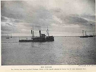
The Yelcho was built in 1906 by the Scottish firm Geo. Brown and Co. of Greenock, on the River Clyde for towage and cargo service of the Chilean Sociedad Ganadera e Industrial Yelcho y Palena, Puerto Montt. In 1908 she was sold to the Chilean Navy and ordered to Punta Arenas as a tug and for periodic maintenance and supply of the lighthouses in that region.
South Bay is a 1.7 km wide bay indenting for 2.8 km between Cape Kemp and Py Point on the south-west coast of Doumer Island in the Palmer Archipelago of Antarctica. It was charted by the British Graham Land Expedition in February 1935 and so named from its position on the island. The summer only Yelcho research station, administered by the Chilean Antarctic Institute, stands on the shore of the bay. The eastern part of the bay is designated as Antarctic Specially Protected Area to shield it from accidental interference because it is the subject of a long-term marine ecology research program.

Milosz Point is a low-lying, ice-free cape on the northern coast of King George Island, the largest of the South Shetland Islands of Antarctica. It lies 4.5 km west of North Foreland at the eastern entrance to Venus Bay and the western entrance to Emerald Cove. It, along with neighbouring Czeslaw Point, has been identified as an Important Bird Area (IBA) by BirdLife International because it supports a large breeding colony of about 17,000 pairs of chinstrap penguins.
Ronalds Point is the rocky point on the north coast of Elephant Island in the South Shetland Islands, Antarctica situated just east of the terminus of Snellius Glacier. The area was visited by early 19th century sealers.
Saffar Island is the rocky island off the north coast of Elephant Island in the South Shetland Islands, Antarctica extending 290 m in west–east direction and 230 m in south–north direction, with a surface area of 3.64 ha. It is separated from Elephant Island by a passage narrowing to 325 m at points.
Biruni Island is the rocky island off the north coast of Elephant Island in the South Shetland Islands, Antarctica 450 m long in southwest–northeast direction and 150 m wide, with a surface area of 3.59 ha. It is separated from Elephant Island by a passage narrowing to 70 m at points. The island was formed as a result of the retreat of Elephant Island's ice cap at the turn of the 21st century.
Eratosthenes Point is the ice-covered, rock-tipped northwest entrance point to Digges Cove on the north coast of Elephant Island in the South Shetland Islands, Antarctica situated just west of the terminus of Snellius Glacier. The area was visited by early 19th century sealers.
Digges Cove is the 1.77 km wide cove indenting for 860 m the north coast of Elephant Island in the South Shetland Islands, Antarctica southeast of Eratosthenes Point. It was formed as a result of the retreat of Snellius Glacier in the late 20th century. The area was visited by early 19th century sealers.
