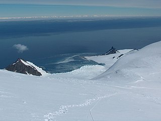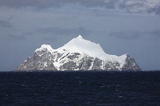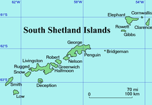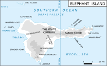
Elephant Island is an ice-covered, mountainous island off the coast of Antarctica in the outer reaches of the South Shetland Islands, in the Southern Ocean. The island is situated 245 kilometres north-northeast of the tip of the Antarctic Peninsula, 1,253 kilometres west-southwest of South Georgia, 935 kilometres south of the Falkland Islands, and 885 kilometres southeast of Cape Horn. It is within the Antarctic claims of Argentina, Chile and the United Kingdom.

Thurston Island is a largely ice-covered, glacially dissected island, 135 nautical miles long and 55 nautical miles wide, lying between between Amundsen Sea and Bellingshausen Sea a short way off the northwest end of Ellsworth Land, Antarctica. The island is separated from the mainland by Peacock Sound, which is occupied by the west portion of Abbot Ice Shelf.

Pardo Ridge is the second highest part of Elephant Island, South Shetland Islands, reaching an altitude of 853 meters. It extends from The White Company in the west to Cape Valentine in the east. It was mapped by the UK Joint Services Expedition, 1970-71, and named by the UK-APC after Captain Luis Pardo, commander of the Chilean tug Yelcho which rescued shipwrecked members of Shackleton's Endurance from Elephant Island's Wild Point in August 1916.

D'Urville Island is the northernmost island of the Joinville Island group in Antarctica. It is 27 kilometres (17 mi) long, lying immediately north of Joinville Island, from which it is separated by Larsen Channel.

Bransfield Strait or Fleet Sea is a body of water about 100 kilometres (60 mi) wide extending for 300 miles (500 km) in a general northeast – southwest direction between the South Shetland Islands and the Antarctic Peninsula.

The borders of the oceans are the limits of Earth's oceanic waters. The definition and number of oceans can vary depending on the adopted criteria. The principal divisions of the five oceans are the Pacific Ocean, Atlantic Ocean, Indian Ocean, Southern (Antarctic) Ocean, and Arctic Ocean. Smaller regions of the oceans are called seas, gulfs, bays, straits, and other terms. Geologically, an ocean is an area of oceanic crust covered by water.

Cape Bowles is a cape forming the southern extremity of Clarence Island in the South Shetland Islands of Antarctica. It was named in 1820 by Edward Bransfield, Master, Royal Navy, while exploring the islands in the brig Williams.

Walker Point is a point on the southwest side of the entrance to Gurkovska Cove which lies 6 km (3.7 mi) south-west of Cape Valentine, near the eastern end of Elephant Island in the South Shetland Islands of Antarctica. The name appears on Powell's map of 1822 based upon the joint cruise of Captain Nathaniel B. Palmer, in the sloop James Monroe with Captain George Powell, in the sloop Dove, in December 1821. It was probably named for Captain John Walker, whose assistance in the construction of the map was acknowledged by Powell.

Point Wild is a point 11 km (6.8 mi) west of Cape Valentine, 2 km (1.2 mi) east of Saddleback Point, and directly adjacent to the Furness Glacier on the north coast of Elephant Island. It was named Cape Wild by the Shackleton Endurance expedition 1914–16, but Point Wild is recommended for this feature because of its small size and to avoid confusion with Cape Wild on George V Coast.

Furness Glacier is a small glacier flowing between Cape Belsham and Point Wild to the north coast of Elephant Island, South Shetland Islands. It was charted and named by the Ernest Shackleton Endurance expedition 1914–16.
Violante Inlet is an ice-filled inlet 16 nautical miles long, in an east–west direction, and 12 to 15 nautical miles wide, lying between Cape Fanning and Cape Herdman along the east coast of Palmer Land, Antarctica.

The Pointers is a pair of rocks off the northwest coast of Rugged Island, lying between Eddystone Rocks and Start Point, Livingston Island in the South Shetland Islands, Antarctica.

Limit Rock is a rock awash, lying 2 nautical miles (4 km) east of North Foreland, the northeast cape of King George Island, in the South Shetland Islands on the Southern Ocean. It was charted in 1937 by Discovery Investigations personnel on the Discovery II, and so named because it marks the eastern limit of foul ground surrounding North Foreland.

Sugarloaf Island is a conspicuous small island which lies close to the east side of Clarence Island, midway between Cape Lloyd and Cape Bowles, in the South Shetland Islands, Antarctica. It lies 3.2 km north of Lebed Point, on the northern side of the entrance to Istros Bay. The name was in use by American and British sealers as early as 1822 and is now well established.

Gaydarov Point is the rocky point forming the south extremity of Cornwallis Island in the South Shetland Islands, Antarctica. It is “named after Captain Kostadin Gaydarov (1933-2019), Director (1983-1986) of the Bulgarian company Ocean Fisheries – Burgas whose ships operated in the waters of South Georgia, Kerguelen, the South Orkney Islands, South Shetland Islands and Antarctic Peninsula from 1970 to the early 1990s. The Bulgarian fishermen, along with those of the Soviet Union, Poland and East Germany are the pioneers of modern Antarctic fishing industry.”

Dzhegov Rock is the solitary rock in eastern Prince Charles Strait, South Shetland Islands in Antarctica extending 40 m in southeast-northwest direction and 30 m in southwest-northeast direction. It is “named after Captain Simeon Dzhegov (1938–2011), Director in 1987 of the Bulgarian company Ocean Fisheries – Burgas whose ships operated in the waters of South Georgia, Kerguelen, the South Orkney Islands, South Shetland Islands and Antarctic Peninsula from 1970 to the early 1990s. The Bulgarian fishermen, along with those of the Soviet Union, Poland and East Germany are the pioneers of modern Antarctic fishing industry.”

Boyadzhiev Point is the rocky northeast entrance point to Gurkovska Cove on the east coast of Elephant Island in the South Shetland Islands, Antarctica. The area was visited by early 19th century sealers.

Saffar Island is the rocky island off the north coast of Elephant Island in the South Shetland Islands, Antarctica extending 290 m in west–east direction and 230 m in south–north direction, with a surface area of 3.64 ha. It is separated from Elephant Island by a passage narrowing to 325 m at points.

Biruni Island is the rocky island off the north coast of Elephant Island in the South Shetland Islands, Antarctica 450 m long in southwest–northeast direction and 150 m wide, with a surface area of 3.59 ha. It is separated from Elephant Island by a passage narrowing to 70 m at points. The island was formed as a result of the retreat of Elephant Island's ice cap at the turn of the 21st century.


