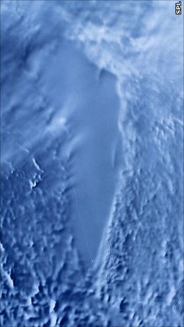
Lake Vostok is the largest of Antarctica's 675 known subglacial lakes. Lake Vostok is located at the southern Pole of Cold, beneath Russia's Vostok Station under the surface of the central East Antarctic Ice Sheet, which is at 3,488 m (11,444 ft) above mean sea level. The surface of this fresh water lake is approximately 4,000 m (13,100 ft) under the surface of the ice, which places it at approximately 500 m (1,600 ft) below sea level.

Casey Station, commonly called Casey, is one of three permanent stations and research outposts in Antarctica managed by the Australian Antarctic Division (AAD). Casey lies on the northern side of the Bailey Peninsula overlooking Vincennes Bay on the Budd Coast of Wilkes Land in the Australian Antarctic Territory, a territory claimed by Australia. Casey is 3,880 kilometres (2,410 mi) due south of Perth, Western Australia.

Vinson Massif is a large mountain massif in Antarctica that is 21 km (13 mi) long and 13 km (8 mi) wide and lies within the Sentinel Range of the Ellsworth Mountains. It overlooks the Ronne Ice Shelf near the base of the Antarctic Peninsula. The massif is located about 1,200 kilometres (750 mi) from the South Pole. Vinson Massif was discovered in January 1958 by U.S. Navy aircraft. In 1961, the Vinson Massif was named by the Advisory Committee on Antarctic Names (US-ACAN), after Carl G. Vinson, United States congressman from the state of Georgia, for his support for Antarctic exploration. On November 1, 2006, US-ACAN declared Mount Vinson and Vinson Massif to be separate entities. Vinson Massif lies within the unrecognised Chilean claim under the Antarctic Treaty System.
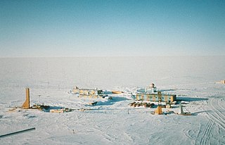
Vostok Station is a Russian research station in inland Princess Elizabeth Land, Antarctica. Founded by the Soviet Union in 1957, the station lies at the southern Pole of Cold, with the lowest reliably measured natural temperature on Earth of −89.2 °C. Research includes ice core drilling and magnetometry. Vostok was named after Vostok, the lead ship of the First Russian Antarctic Expedition captained by Fabian von Bellingshausen. The Bellingshausen Station was named after this captain.
The Vestfold Hills are rounded, rocky, coastal hills, 512 square kilometres (198 sq mi) in extent, on the north side of Sorsdal Glacier on the Ingrid Christensen Coast of Princess Elizabeth Land, Antarctica. The hills are subdivided by three west-trending peninsulas bounded by narrow fjords. Most of the hills range between 30 and 90 metres in height, with the highest summit reaching nearly 160 metres (520 ft).

The David Range (67°54′S62°30′E is a mountain range that extends for 26 kilometres in the Framnes Mountains of Mac.Robertson Land in Antarctica. The range is surrounded by, and largely covered by, an ice sheet. Only the peaks are visible.

The Mirny Station is a Russian first Antarctic science station located in Queen Mary Land, Antarctica, on the Antarctic coast of the Davis Sea.
The Soviet Antarctic Expedition was part of the Arctic and Antarctic Research Institute of the Soviet Committee on Antarctic Research of the Academy of Sciences of the USSR. It was succeeded by the Russian Antarctic Expedition.
The Third Soviet Antarctic Expedition (1957–59) was led by Yevgeny Tolstikov on the continent and included Czech future astronomer Antonín Mrkos; the marine expedition on the Ob was led by I V Maksimov.

The Pole of Inaccessibility research station is a defunct Soviet research station in Kemp Land, Antarctica, at the southern pole of inaccessibility as defined in 1958 when the station was established. Later definitions give other locations, all relatively near this point. It performed meteorological observations from 14 to 26 December 1958. The Pole of Inaccessibility has the world's coldest year-round average temperature of −58.2 °C (−72.8 °F).
Leningradskaya station is a Russian Antarctic research station, located in the northern shore of Victoria Land, at the Oates Coast. It was opened on February 25, 1971 by the members of the 15th Soviet Antarctic Expedition. It closed in 1991, but during its lifetime was host to studies of meteorology, Earth magnetism, oceanology and glaciology.
The Russkaya Station is a former Soviet and Russian Antarctic research station located on the Ruppert Coast, in Marie Byrd Land in Western Antarctica. The station was proposed in 1973 and approved in 1978. Construction began the next year and it was opened on March 9, 1980 and officially abandoned in 1990.
Komsomolskaya was a Soviet Antarctic inland research station founded in 1957 in Queen Mary Land, in eastern Antarctica. It was a year-round station till 1959, then used as a seasonal outpost till 1962 when it was shut down permanently. Nonetheless it is still used as a fuel storage stop for supply caravans en route from Mirny Station to Vostok Station.

Troll is a Norwegian research station located at Jutulsessen, 235 kilometres (146 mi) from the coast in the eastern part of Princess Martha Coast in Queen Maud Land, Antarctica. It is Norway's only all-year research station in Antarctica, and is supplemented by the summer-only station Tor. Troll is operated by the Norwegian Polar Institute and also features facilities for the Norwegian Meteorological Institute and the Norwegian Institute for Air Research.

Zucchelli Station is an Italian seasonal research station in Antarctica, located at Terra Nova Bay on a granitic headland along the coast of the Northern Foothills to the north-east of Gerlache Inlet. It has been named after Mario Zucchelli, director of the activities, which conducted for sixteen years, for the ENEA-Unità Tecnica Antartide as part of the National Antarctic Research Program (PNRA).

Dome Fuji, also called Dome F or Valkyrie Dome, is an Antarctic base located in the eastern part of Queen Maud Land. With an altitude of 3,810 metres (12,500 ft) above sea level, it is the second-highest summit or ice dome of the East Antarctic Ice Sheet and represents an ice divide. Dome F is the site of Dome Fuji Station, a research station operated by Japan.
The Gamburtsev Mountain Range is a subglacial mountain range located in East Antarctica, just underneath the lofty Dome A, near the Southern Pole of Inaccessibility. The range was discovered by the 3rd Soviet Antarctic Expedition in 1958 and is named for Soviet geophysicist Grigoriy A. Gamburtsev. It is approximately 1,200 kilometres (750 mi) long, and the mountains are believed to be about 2,700 metres (8,900 ft) high, although they are completely covered by over 600 metres (2,000 ft) of ice and snow. The Gamburtsev Mountain Range is about the same size as the European Alps. As of 2008, it was unknown how the mountains were formed due to the lack of data. Studies conducted during the International Polar year demonstrated that ancient plate collisions produced a core that was rejuvenated in the early to mid-Mesozoic. The main features of the range formed before 34 million years ago, when the area was covered by the present ice sheet. Current models suggest that the East Antarctic ice sheet was formed from the glaciers that began sliding down the Gamburtsev range at the end of the Eocene. Vostok Subglacial Highlands form an east extension of Gamburtsev Subglacial Mountains.

Queen Maud Land is a roughly 2.7-million-square-kilometre (1.0-million-square-mile) region of Antarctica claimed by Norway as a dependent territory. It borders the claimed British Antarctic Territory 20° west and the Australian Antarctic Territory 45° east. In addition, a small unclaimed area from 1939 was annexed in June 2015. Positioned in East Antarctica, it makes out about one-fifth of the continent, and is named after the Norwegian Queen Maud (1869–1938).
Bharati is a permanent Antarctic research station commissioned by India. It is India's third Antarctic research facility and one of two active Indian research stations, alongside Maitri. India's first committed research facility, Dakshin Gangotri, is being used as a supply base. India has demarcated an area beside Larsemann Hills at 69°S, 76°E for construction. The research station has been operational since 18 March 2012, though it is still being run on trial basis and formal launch is awaited. Since its completion, India has become one of nine nations to have multiple stations within the Antarctic Circle. Bharati's research mandate focuses on oceanographic studies and the phenomenon of continental breakup. It also facilitates research to refine the current understanding of the Indian subcontinent's geological history. News sources have referred to the station as "Bharathi", "Bharti" and "Bharati".

