This article needs additional citations for verification .(December 2025) |
You can help expand this article with text translated from the corresponding article in German. (April 2012)Click [show] for important translation instructions.
|
Neumayer Station II Neumayer-Station II | |
|---|---|
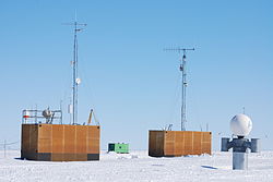 The station in 2008 | |
 Neumayer Station II Location in Antarctica | |
| Coordinates: 70°38′24″S8°15′43″W / 70.6400°S 8.2619°W | |
| Region | Queen Maud Land |
| Location | Near Atka Iceport |
| Established | March 1992 |
| Closed | 20 February 2009 |
| Named after | Georg von Neumayer |
| Government | |
| • Type | Administration |
| • Body | AWI, Germany |
| UN/LOCODE | AQ NEU |
| Active times | All year-round |
| Website | awi.de |
Neumayer Station or Neumayer Station II was a permanent German Antarctic research base on Atka Bay. [1] It opened in 1992, replacing the old Georg von Neumayer Station.
The station became increasingly deformed by snow and ice movements after 2007 and was therefore uninhabitable. On February 20, 2009, it was handed over to South Africa and replaced by the new permanent research base Neumayer Station III. At the time, the station was moving with the shelf ice at about 200 meters per year towards the open sea. The South African National Antarctic Programme dismantled the station in 2009 and built a new Emergency Base (E-Base) at the same location.
Georg von Neumayer Station Georg-von-Neumayer-Station | |
|---|---|
 Interactive map of Georg von Neumayer Station | |
| Coordinates: 70°36′00″S8°22′00″W / 70.6000°S 8.3667°W | |
| Region | Queen Maud Land |
| Location | Near Atka Iceport |
| Established | 28 January 1981 |
| Closed | 23 February 1993 |
| Named after | Georg von Neumayer |
| Government | |
| • Type | Administration |
| • Body | AWI, Germany |
| Active times | All year-round |


