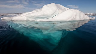
An iceberg is a piece of freshwater ice more than 15 m long that has broken off a glacier or an ice shelf and is floating freely in open (salt) water. Smaller chunks of floating glacially derived ice are called "growlers" or "bergy bits". Much of an iceberg is below the water's surface, which led to the expression "tip of the iceberg" to illustrate a small part of a larger unseen issue. Icebergs are considered a serious maritime hazard.

The Weddell Sea is part of the Southern Ocean and contains the Weddell Gyre. Its land boundaries are defined by the bay formed from the coasts of Coats Land and the Antarctic Peninsula. The easternmost point is Cape Norvegia at Princess Martha Coast, Queen Maud Land. To the east of Cape Norvegia is the King Haakon VII Sea. Much of the southern part of the sea is covered by a permanent, massive ice shelf field, the Filchner-Ronne Ice Shelf.

RV Polarstern is a German research icebreaker of the Alfred Wegener Institute for Polar and Marine Research (AWI) in Bremerhaven, Germany. Polarstern was built by Howaldtswerke-Deutsche Werft in Kiel and Nobiskrug in Rendsburg, was commissioned in 1982, and is mainly used for research in the Arctic and Antarctica. The ship has a length of 118 metres and is a double-hulled icebreaker. She is operational at temperatures as low as −50 °C (−58 °F). Polarstern can break through ice 1.5 m thick at a speed of 5 knots. Thicker ice of up to 3 m (9.8 ft) can be broken by ramming.

An ice shelf is a large floating platform of ice that forms where a glacier or ice sheet flows down to a coastline and onto the ocean surface. Ice shelves are found in Antarctica and the Arctic. The boundary between the floating ice shelf and the anchor ice that feeds it is the grounding line. The thickness of ice shelves can range from about 100 m (330 ft) to 1,000 m (3,300 ft). The world's largest ice shelves are the Ross Ice Shelf and the Filchner-Ronne Ice Shelf in Antarctica. When a large piece of an ice shelf breaks off, this can lead to the formation of an iceberg. This process is also called ice calving.

The Filchner–Ronne Ice Shelf or Ronne–Filchner Ice Shelf is an Antarctic ice shelf bordering the Weddell Sea.

Berkner Island is an Antarctic ice rise, where bedrock below sea level has caused the surrounding ice sheet to create a dome. If the ice cap were removed, the island would be underwater. Berkner Island is completely ice-covered and is about 320 kilometres (200 mi) long and 150 kilometres (93 mi) wide, with an area of 44,000 km2 (17,000 sq mi). It is surrounded by the Filchner-Ronne Ice Shelf. The northernmost point of the Berkner is about 20 kilometres (12 mi) from the open sea. It lies in the overlapping portion of the Argentine and the British Antarctic territorial claims.

The Alfred Wegener Institute, Helmholtz Centre for Polar and Marine Research is located in Bremerhaven, Germany, and a member of the Helmholtz Association of German Research Centres. It conducts research in the Arctic, the Antarctic, and the high and mid latitude oceans. Additional research topics are: North Sea research, marine biological monitoring, and technical marine developments. The institute was founded in 1980 and is named after meteorologist, climatologist, and geologist Alfred Wegener.

The Amery Ice Shelf is a broad ice shelf in Antarctica at the head of Prydz Bay between the Lars Christensen Coast and Ingrid Christensen Coast. It is part of Mac. Robertson Land. The name "Cape Amery" was applied to a coastal angle mapped on 11 February 1931 by the British Australian New Zealand Antarctic Research Expedition (BANZARE) under Douglas Mawson. He named it for William Bankes Amery, a civil servant who represented the United Kingdom government in Australia (1925–28). The Advisory Committee on Antarctic Names interpreted this feature to be a portion of an ice shelf and, in 1947, applied the name Amery to the whole shelf.

Luitpold Coast is that portion of the coast of Coats Land extending from the vicinity of Hayes Glacier, at 27°54′W, to 36°W, which is regarded as the eastern limit of the Filchner Ice Shelf. It was discovered by Wilhelm Filchner, leader of the Second German Antarctic Expedition, 1911–12, and named after Luitpold, Prince Regent of Bavaria.

The Second German Antarctic Expedition of 1911–1913 was led by Wilhelm Filchner in the exploration ship Deutschland. Its principal objective was to determine whether the Antarctic continent comprised a single landmass rather than separated elements, and in particular whether the Weddell Sea and Ross Sea were connected by a strait. In addition, an extensive programme of scientific research was undertaken. The expedition failed to establish a land base, and the ship became beset in the Weddell Sea ice, drifting north for eight months before reaching open water. The expedition was marred by considerable disagreement and animosity among its participants, and broke up in disarray.

Neumayer Station III, also known as Neumayer III after geophysicist Georg von Neumayer, is a German Antarctic research station of the Alfred-Wegener-Institut. It is located on the approximately 200 metres (660 ft) thick Ekström Ice Shelf several kilometres south of Neumayer Station II. The station's assembly kit was transported to its current position early in November 2007. It is moving with the shelf ice at about 157 meters (515 ft) per year towards the open sea.

Ellsworth Scientific Station was a permanent, all year-round originally American, then Argentine Antarctic scientific research station named after American polar explorer Lincoln Ellsworth. It was located on Gould Bay, on the Filchner Ice Shelf.

Kohnen-Station is a German summer-only polar research station in the Antarctic, able to accommodate up to 28 people. It is named after the geophysicist Heinz Kohnen (1938–1997), who was for a long time the head of logistics at the Alfred Wegener Institute.
Ice2sea was a program of scientific research funded by the European Union's Framework 7 Programme to study the effects of climate change on glaciation and the melting of ice caps and glaciers on sea level. The ice2sea project, a collaborative of 24 research institutions, which was headed by Prof David Vaughan, aimed to reduce the uncertainty in sea-level projections which are of great economic and social importance to European, especially as large areas of coastal Europe are below or less than a metre above sea level.

A-38 was a large iceberg that split from the Filchner-Ronne Ice Shelf in Antarctica in October 1998. Soon after formation it split into two pieces, A-38A and A-38B, which drifted westwards on the Weddell Gyre. The icebergs moved north along the Antarctic Peninsula and reached its tip in February 2003. A-38A and A-38B increased speed in open sea and grounded in shallower waters to the east of South Georgia Island in December 2003. A-38A broke up into three pieces in March 2004 and drifted north where it decayed. A-38B split into two in April, with the eastern portion, now known as A-38G, drifting north and west to decay. The remainder of A-38B remained grounded, interfering with the foraging routes of seals and penguins in South Georgia, resulting in the deaths of their young. On 20 August A38-B broke into two, with the new portion drifting north and breaking up. The remainder of A-38B continued to break up through September 2004 and had completely decayed by 2005.

Research stations in Queen Maud Land are connected by the Dronning Maud Land Air Network Project (DROMLAN), which is a cooperative agreement for transportation between eleven nations with research stations in East Antarctica. Long-range aircraft fly between Cape Town, South Africa and either the Troll Airfield, located at the Troll research station, or the runway at the Novolazarevskaya Station. From these two main airfields, smaller aircraft may fly further to other Antarctic destinations.

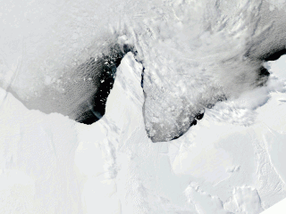
Iceberg A-74 is an iceberg that calved from the north side of the Antarctic Brunt Ice Shelf in February 2021. Its calving had been anticipated due to large ice rifts that opened up in September 2019 and spread in the Antarctic summer of 2020–21. The iceberg measured 1,270 square kilometres (490 sq mi) soon after calving. It has moved away from the Antarctic coast which allowed, on 13–14 March 2021, the research vessel Polarstern to complete a circumnavigation as part of a research expedition. The Polarstern has photographed the sea bed which has provided an insight into fauna that can survive up to 30 kilometres (19 mi) from the nearest daylight.
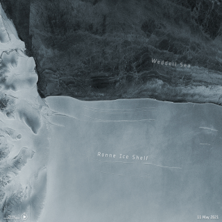
In mid-May 2021, A-76 was, before it broke into three, the world's largest floating iceberg, calved from the Filchner–Ronne Ice Shelf in Antarctica.
Drescher Ice Camp can refer to a decommissioned permanent research station in the Drescher Inlet on the Riiser-Larsen Ice Shelf as well as any subsequent mobile research stations located at the same site. The ice camp, and the inlet where it is located, are named after Alfred Wegener Institute biologist Eberhard Drescher.
Druzhnaya Station is any one of four different Antarctic research stations operated by the Soviet Union and later Russia from 1976 to 2013.

