Law
The laws of the Cook Islands Federation were made by the local parliament, however, they had to receive approval from a Resident from Britain. [3] In 1894, the Parliament pronounced a declaration on land, detailing Māori custom on land tenure, and stating that those customs could only be changed by each island's respective council. [4]
In 1899, the Parliament of Cook Islands ruled that the high court of the Cook Islands Federation could not give any punishment worse than those outlined by the Criminal Code Act of 1893, and The Summary Jurisdiction Act of 1894, which were both laws of New Zealand, and that both acts of New Zealand were to be adopted entirely. [5]
Penal colonies
In 1892, the island of Takutea was set up as a penal colony, but in 1899 its use ceased, and the island of Manuae was used instead. [5]

The Cook Islands is an island country in Polynesia, part of Oceania in the South Pacific Ocean. It consists of 15 islands whose total land area is approximately 236.7 square kilometres (91 sq mi). The Cook Islands' Exclusive Economic Zone (EEZ) covers 1,960,027 square kilometres (756,771 sq mi) of ocean. Avarua is its capital.
The Cook Islands are named after Captain James Cook, who visited the islands in 1773 and 1777, although Spanish navigator Alvaro de Mendaña was the first European to reach the islands in 1595. The Cook Islands became aligned to the United Kingdom in 1890, largely because of the fear of British residents that France might occupy the islands as it already had Tahiti.

The Cook Islands can be divided into two groups: the Southern Cook Islands and the Northern Cook Islands. The country is located in Oceania, in the South Pacific Ocean, about halfway between Hawaii and New Zealand.
This article lists transport in the Cook Islands.

Aitutaki, also traditionally known as Araʻura and Utataki, is the second most-populated island in the Cook Islands, after Rarotonga. It is an "almost atoll", with fifteen islets in a lagoon adjacent to the main island. Total land area is 18.05 km2 (6.97 sq mi), and the lagoon has an area of between 50 and 74 km2. A major tourist destination, Aitutaki is the second most visited island of the Cook Islands archipelago.

Rarotonga is the largest and most populous of the Cook Islands. The island is volcanic, with an area of 67.39 km2 (26.02 sq mi), and is home to almost 75% of the country's population, with 10,898 of a total population of 15,040. The Cook Islands' Parliament buildings and international airport are on Rarotonga. Rarotonga is a very popular tourist destination with many resorts, hotels and motels. The chief town, Avarua, on the north coast, is the capital of the Cook Islands.
The flag of the Cook Islands, officially known as the Cook Islands Ensign, is based on the traditional design for former British colonies in the Pacific region. It is a blue ensign containing the Union Flag in the upper left, and on the right, fifteen stars in a ring. The Union Flag is symbolic of the nation's historic ties to the United Kingdom and to the Commonwealth of Nations. The stars stand for the fifteen islands that make up the Cook Islands. The blue represents the ocean and the peaceful nature of the inhabitants.

Mangaia is the most southerly of the Cook Islands and the second largest, after Rarotonga. It is a roughly circular island, with an area of 51.8 square kilometres (20.0 sq mi), 203 kilometres (126 mi) from Rarotonga. Originally heavily populated, Mangaia's population has dropped by 75% in the last 50 years, mainly due to the decline of the pineapple industry in the 1980s and a subsequent economic crisis in 1996.

Ātiu, also known as ʻEnuamanu, is an island of the Cook Islands archipelago, lying in the central-southern Pacific Ocean. Part of the Nga-pu-Toru, it is 214 km (133 mi) northeast of Rarotonga. The population of the 26.9 square kilometres (10.4 sq mi) island has dropped by two-thirds in the last 50 years.

Rarotonga International Airport is the Cook Islands' main international gateway, located in the town and district of Avarua, Rarotonga, 3 km (1.9 mi) west of the downtown area on the northern coast. Originally built in 1944, the airport was expanded in the early 1970s, and officially opened for jets in January 1974.

Albert Royle Henry was the first Premier of the Cook Islands and the founder and first leader of the Cook Islands Party (CIP). First elected Premier in August 1965, he was unseated in the aftermath of the 1978 election after an electoral petition found he had committed electoral fraud. He was later stripped of his knighthood. In 2023 he was posthumously pardoned.

The Parliament of the Cook Islands is the legislature of the Cook Islands. Originally established under New Zealand administration, it became the national legislature upon independence in 1965.

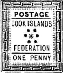
The Kingdom of Rarotonga, named after the island of Rarotonga, was an independent kingdom established in the present-day Cook Islands in 1858. In 1888 it became a protectorate of the United Kingdom at its own request. In 1893 the name was changed to the Cook Islands Federation.
Sir Geoffrey Arama Henry was a Cook Island politician who was twice the Prime Minister of the Cook Islands. He was leader of the Cook Islands Party (CIP) from 1979 to 2006.
Sir Pupuke Robati, KBE was a Cook Island politician. He served as Prime Minister of the Cook Islands from 29 July 1987 to 1 February 1989.
Marguerite Nora Eikura Kitimira Story,, was the Speaker of the Legislative Assembly of the Cook Islands from 1965 to 1979. She was the first female cabinet member in the Cook Islands and the first woman in the Commonwealth to become speaker of a national parliament.

Pa Maretu Ariki was a sovereign of the Cook Islands. He was the ariki of the Pa dynasty, one of the two chiefdoms of the Takitumu tribe on the island of Rarotonga.

Pa Upoko Takau Ariki was a sovereign of the Cook Islands. She was the ariki of the Pa dynasty, one of the two chiefdoms of the Takitumu tribe on the island of Rarotonga.

The Cook Islands Progressive Association (CIPA) was the first indigenous political organisation in the Cook Islands. Initially focused on economic advancement for the islands, it came to advocate for greater self-rule. It was an ancestor of the Cook Islands Party.

The Church of Jesus Christ of Latter-day Saints in the Cook Islands refers to the Church of Jesus Christ of Latter-day Saints and its members in Cook Islands. The first regularly held Sunday meetings began in 1943. In 2022, there were 1,862 members in 5 congregations.