Manuae (Cook Islands)

Last updated

Manuae
Manuae (Cook Islands) Aerial.jpg
An aerial view of Manuae
Cook-Islands-map.gif
Geography
Area6.17 km2 (2.38 sq mi)
Highest elevation5 m (16 ft)
Administration
Demographics
Population0 (2021)

Manuae is an uninhabited atoll in the southern group of the Cook Islands, 100 kilometres south-east of Aitutaki. Manuae is not administratively part of Aitutaki, however, it is part of Arutanga-Reureu-Nikaupara Constituency on Aitutaki for electoral purposes only.

Contents

Geographic description

Map of Manuae Manuae.png
Map of Manuae

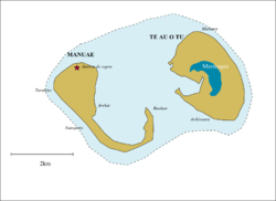
Manuae is a true atoll sitting on the peak of a submerged volcano which descends over 4000 meters to the ocean bed. It comprises two horseshoe-shaped islets, Manuae islet to the west and Te Au O Tu islet to the east, with a total area of 6 km2 [1] on either side of a lagoon about 7 km x 4 km. Manuae islet has an area of 2.1 km2, while Te Au O Tu islet is 3.9 km2. [2] The lagoon is 13 km2 in size, shallow and subject to large shifting sand banks. [3] A coral reef surrounds the atoll, and there is no major passage through the reef. [4]

The waters surrounding the island are a marine park and it is an important breeding ground for seabirds and marine turtles in the Central Pacific. The offshore waters of Manuae are good fishing grounds.

History

Silver coin: 7 1/2 Dollar Cook Islands, Commemorating James Cook's discovery of Hervey Island (1773-1974) 7 1/2 Dollars - Elizabeth II Hervey Islands 1974.png
Silver coin: 7½ Dollar Cook Islands, Commemorating James Cook's discovery of Hervey Island (1773-1974)

According to oral tradition, Manuae was discovered by Ruatapu, who named it Manu-enua ("bird-land"). [1] Ruatapu planted coconuts and released birds there, and later sent his second son and his family to settle the island. Another tradition states that the island was first settled by two brothers from Atiu, and that Ruatapu found it already inhabited. [1] Later the island was attacked by Mangaia. [1]

Captain James Cook sighted Manuae on his second voyage on 23 September 1773, but did not land. [1] He visited again on 6 April 1777 during his third voyage, and found the island inhabited and apparently under the control of an Ariki from Atiu. [1] Cook initially named Manuae "Sandwich Island", but changed it to "Hervey Island" in honor of Augustus Hervey, 3rd Earl of Bristol, then a Lord of the Admiralty. This name was later corrupted to Hervey's Island, or Hervey's Isle, and later applied to the entire southern group, as the Hervey Islands. [5] :92

In July 1823 the island was visited by John Williams of the London Missionary Society, who found it inhabited by sixty people. [1] The island was depopulated shortly afterwards, and by 1852 was home to a single family. [1] In 1888 it was declared to be a British protectorate. [6] In 1898 it was leased out as a copra plantation. [7] In 1900 it was annexed by New Zealand. [8]

In April/May 1965 the population briefly increased to more than a hundred when the island was visited by six expeditions (from Australia, N.Z., Japan, U.K., U.S.A. and U.S.S.R.) to observe the total solar eclipse of 30 May 1965. [9]

Norwegian author Erlend Loe writes humorously about an expedition to Manuae in his 1999 novel " L ".

In April 2020 the Cook Islands National Environment Service advertised for two caretakers to live on the island for a year. [10]

The Proprietors of Manuae Incorporated (PMI) were established by court order in 1983. The committee members are elected by the indigenous landowners of Manuae Atoll on a regular basis. In October 2022, the PMI established the not-for-profit Manuae Enua Conservation Trust (MECT) to represent the landowners’ interests in managing the island of Manuae for conservation action and sustainable development. [11]

Economy and improvements

The island once supported a copra industry with a settlement established next to the small reef passage less than one kilometer northeast of Turakino, the westernmost point of the atoll. The passage, at the sea entrance, is less than 4 metres wide and in a swell is exceedingly dangerous without local knowledge.

The island has an airfield, an overgrown coral airstrip barely visible, that has been out of use for several years.

Fishermen from Aitutaki occasionally organise trips to Manuae. [3]

Demography

The population peaked with 32 at the 1956 census, but twenty years later the island was abandoned.

Historical population
YearPop.±%
192623    
19368−65.2%
195632+300.0%
196118−43.8%
YearPop.±%
196616−11.1%
19712−87.5%
19760−100.0%
Papers Past [12]

See also

Related Research Articles

<span class="mw-page-title-main">Cook Islands</span> Country in the South Pacific Ocean

The Cook Islands is an island country in Polynesia, part of Oceania in the South Pacific Ocean. It consists of 15 islands whose total land area is approximately 236.7 square kilometres (91 sq mi). The Cook Islands' Exclusive Economic Zone (EEZ) covers 1,960,027 square kilometres (756,771 sq mi) of ocean. Avarua is its capital.

<span class="mw-page-title-main">Geography of the Cook Islands</span>

The Cook Islands can be divided into two groups: the Southern Cook Islands and the Northern Cook Islands. The country is located in Oceania, in the South Pacific Ocean, about halfway between Hawaii and New Zealand.

<span class="mw-page-title-main">Aitutaki</span> Island in the Cook Islands

Aitutaki, also traditionally known as Araʻura and Utataki, is the second most-populated island in the Cook Islands, after Rarotonga. It is an "almost atoll", with fifteen islets in a lagoon adjacent to the main island. Total land area is 18.05 km2 (6.97 sq mi), and the lagoon has an area of between 50 and 74 km2. A major tourist destination, Aitutaki is the second most visited island of the Cook Islands archipelago.

Ruatapu was a son of the great chief Uenuku, and a master canoeist in Polynesian tradition who is said to have lived around 30 generations ago. Most Māori stories agree he was an older half-brother of Paikea and 69 other sons, while traditions recorded from the Cook Islands sometimes state he was Uanuku Rakeiora's only son.

<span class="mw-page-title-main">Rarotonga</span> Island of the Cook Islands

Rarotonga is the largest and most populous of the Cook Islands. The island is volcanic, with an area of 67.39 km2 (26.02 sq mi), and is home to almost 75% of the country's population, with 10,898 of a total population of 15,040. The Cook Islands' Parliament buildings and international airport are on Rarotonga. Rarotonga is a very popular tourist destination with many resorts, hotels and motels. The chief town, Avarua, on the north coast, is the capital of the Cook Islands.

<span class="mw-page-title-main">Butaritari</span> Atoll in the Pacific Ocean island nation of Kiribati

Butaritari is an atoll in the Pacific Ocean island nation of Kiribati. The atoll is roughly four-sided. The south and southeast portion of the atoll comprises a nearly continuous islet. The atoll reef is continuous but almost without islets along the north side. Bikati and Bikatieta islets occupy a corner of the reef at the extreme northwest tip of the atoll. Small islets are found on reef sections between channels on the west side. The lagoon of Butaritari is deep and can accommodate large ships, though the entrance passages are relatively narrow. It is the most fertile of the Gilbert Islands, with relatively good soils and high rainfall. Butaritari atoll has a land area of 13.49 km2 (5.21 sq mi) and a population of 3,224 as of 2015. During World War II, Butaritari was known by United States Armed Forces as Makin Atoll, and was the site of the Battle of Makin. Locally, Makin is the name of a separate but closest atoll, 3 kilometres to the northeast of Butaritari, but close enough to be seen. These two atolls share a dialect of the Gilbertese language.

<span class="mw-page-title-main">Penrhyn atoll</span> Atoll in Cook Islands

Penrhyn is an atoll in the northern group of the Cook Islands in the south Pacific Ocean. The northernmost island in the group, it is located at 1,365 km (848 mi) north-north-east of the capital island of Rarotonga, 9 degrees south of the equator. Its nearest neighbours are Rakahanga and Manihiki, approximately 350 kilometres (220 mi) to the southwest. Once one of the most heavily populated atolls, it was almost completely depopulated by Peruvian slavers in 1864.

<span class="mw-page-title-main">Pukapuka</span> Atoll in the northern Cook Islands

Pukapuka, formerly Danger Island, is a coral atoll in the northern group of the Cook Islands in the Pacific Ocean. It is one of the most remote islands of the Cook Islands, situated about 1,140 kilometres northwest of Rarotonga. On this small island, an ancient culture and distinct language have been maintained over many centuries. The population of Puka Puka is around 400 people.

<span class="mw-page-title-main">Palmerston Island</span> Island in the Cook Islands

Palmerston Island is a coral atoll in the Cook Islands in the Pacific Ocean about 290 miles (470 km) northwest of Rarotonga. James Cook landed there on 16 June 1774.

<span class="mw-page-title-main">Atiu</span>

Ātiu, also known as ʻEnuamanu, is an island of the Cook Islands archipelago, lying in the central-southern Pacific Ocean. Part of the Nga-pu-Toru, it is 214 km (133 mi) northeast of Rarotonga. The population of the 26.9 square kilometres (10.4 sq mi) island has dropped by two-thirds in the last 50 years.

Cook Islands Māori is an Eastern Polynesian language that is the official language of the Cook Islands. Cook Islands Māori is closely related to New Zealand Māori, but is a distinct language in its own right. Cook Islands Māori is simply called Māori when there is no need to disambiguate it from New Zealand Māori, but it is also known as Māori Kūki ʻĀirani or, controversially, Rarotongan. Many Cook Islanders also call it Te reo Ipukarea, literally "the language of the Ancestral Homeland".

<span class="mw-page-title-main">Rakahanga</span> Atoll in the Cook Islands

Rakahanga is part of the Cook Islands, situated in the central-southern Pacific Ocean. The unspoilt atoll is 1,248 kilometres from the Cook Islands' capital, Rarotonga, and lies 1,111 kilometres south of the equator. Its nearest neighbour is Manihiki which is just 44 kilometres away. Rakahanga's area is 4 square kilometres (1.5 sq mi). Its highest point is approximately 5 metres above sea level. The population was 83 in the 2016 Census of Population & Dwellings, with a density ratio of 32 people per square kilometer. Since 2014 Rakahanga's electicity has been 100% solar generated. The Rakahanga-Manihiki language differs from Cook Islands Maori.

<span class="mw-page-title-main">Takutea</span> Small island of the Cook Islands

Takutea is a small uninhabited island in the Cook Islands, 21 kilometres north-west of Atiu. Administratively, the island is considered part of Atiu, the closest island. It is owned equally by all inhabitants of Atiu and not allocated to one specific village or district of Atiu.

<span class="mw-page-title-main">Maupihaa</span> Atoll in French Polynesia

Maupihaa, also known as Mopelia, is an atoll in the Leeward group of the Society Islands, in the South Pacific. This atoll is located 72 km southeast of Manuae, its nearest neighbor.

<span class="mw-page-title-main">Muritapua</span> Island in the Cook Islands

Muritapua is one of 22 islands in the Aitutaki atoll of the Cook Islands. It is a small islet located on the eastern perimeter of Aitutaki Lagoon between the larger islands of Akaiami and Tekopua, six kilometres to the southeast of the main island of Aitutaki. The island is 360m long and 150m wide.

<span class="mw-page-title-main">Cook Islands Federation</span> British colony (1891–1901)

The Cook Islands Federation was created in 1891, after the Kingdom of Rarotonga was given the island of Aitutaki. It lasted until 1901, when it was given to New Zealand.

A Tapere or Sub-District is a low level of traditional land subdivision on five of the Southern Cook Islands, comparable to the ahupua'a of the main Hawaiian Islands or to the kousapw of Pohnpei. Among the populated raised islands, only Mitiaro is not subdivided into tapere. The remaining Southern Cook Islands, Manuae, Palmerston and Takutea are atolls and/or uninhabited, and therefore not subject to this type of traditional subdivision. The atolls of the Northern Cook Islands are subdivided into motu, instead.

The Ootu Peninsula, though connected to the main island of Aitutaki atoll of the Cook Islands, may in many respects be considered as one of the reef islands, being the largest and longest of them. It is located at the northern end of the eastern perimeter of Aitutaki Lagoon to the north and then west of the northernmost true reef island, Akitua, from which is separated by a channel 50 metres wide and less than two metres deep. The southernmost point of the peninsula is called Aumoana. The northernmost point of the peninsula, Teaumera, is also the northernmost point of Aitutaki as a whole. In the northeast is Kopu a Ruatapu, a boat passage through the fringing coral reef.

<span class="mw-page-title-main">Cook Islands tropical moist forests</span> Terrestrial ecoregion in the Cook Islands

The Cook Islands tropical moist forests is a tropical and subtropical moist broadleaf forests ecoregion that covers the Southern Cook Islands in the Cook Islands.

<span class="mw-page-title-main">Geology of the Cook Islands</span> Geology of Cook Islands

There are fifteen Cook Islands, all being related to extinct volcanoes that have erupted in the volcanic hotspot highway of the south-central Pacific Ocean. Low islands include six of the more northern islands that are atolls, and four of the more southern being uplifted coral islands. Rarotonga, the largest island of the group is a mountainous volcanic island. Rock formations include late Pliocene to more recent volcanics, Oligocene and Miocene reefs and middle Tertiary limestone underlying atolls More recent emergence of the coral reefs is characterised in several cases consistent with sealevel fall at Mangaia, of at least 1.7 m in the last 3400 years. The northern Suwarrow Atoll rim has portions of reef dated to between 4680 and 4310 years B.P. and at the northeast of the atoll the three ridges are dated from the land out at 4220 years B.P., 3420 years B.P. and from 1250 years B.P. On Mitiaro the centre of the reef flat has regions dated 5140–3620 years B.P.

References

  1. 1 2 3 4 5 6 7 8 Alphons M.J. Kloosterman (1976). Discoverers of the Cook Islands and the Names they Gave. Cook Islands Library and Museum. p. 21. Retrieved 29 July 2020.
  2. A. H. McLintock, ed. (1966). "ISLAND TERRITORIES: COOK ISLANDS" . Retrieved 29 July 2020 via Te Ara – the Encyclopedia of New Zealand.
  3. 1 2 "Basic Information on the Marine Resources of the Cook Islands" (PDF). Ministry of Marine Resources. p. 37. Retrieved 22 January 2022.
  4. "SECTOR 2: THE LINE ISLANDS, THE COOK ISLANDS, THE SAMOA ISLANDS, AND THE TONGA ISLANDS (INCLUDING OFF-LYING ISLANDS AND REEFS)". Sailing Directions (enroute) for the Pacific Islands (PDF). Defense Mapping Agency, Hydrographic/Topographic Center. 2002. p. 50. Archived (PDF) from the original on 25 October 2004.
  5. te Rangi Hiroa (1945). An Introduction to Polynesian Anthropology. Honolulu: Bernice P. Bishop Museum. Retrieved 18 November 2021 via NZETC.
  6. "The Cook Group". Ashburton Guardian. 15 October 1888. p. 2. Retrieved 18 November 2021 via Papers Past.
  7. "SOLAR ECLIPSE WILL PUT TINY MANUAE ON THE MAP". Pacific Islands Monthly. Vol. 35, no. 2. 1 February 1964. p. 85. Retrieved 18 November 2021 via National Library of Australia.
  8. "PACIFIC ISLANDS ANNEXATION". Otago Witness. 10 October 1900. p. 11. Retrieved 18 November 2021 via Papers Past.
  9. "'Black Disappointment' For Island Eclipse Watchers". Pacific Islands Monthly. Vol. 36, no. 7. 1 July 1965. pp. 71–72. Retrieved 18 November 2021 via National Library of Australia.
  10. "'Best job in world' advertised in Cook Islands". RNZ. 7 April 2020. Retrieved 29 July 2020.
  11. "'Manuae Enua Conservation Trust'" . Retrieved 29 April 2023.
  12. "COOK ISLANDS – Lower Group Census". Evening Post. 28 May 1936. p. 10. Retrieved 29 July 2020 via National Library of New Zealand.

19°15′27″S158°56′20″W / 19.25750°S 158.93889°W / -19.25750; -158.93889