Related Research Articles

An atoll, sometimes known as a coral atoll, is a ring-shaped coral reef, including a coral rim that encircles a lagoon partially or completely. There may be coral islands or cays on the rim. Atolls are located in warm tropical or subtropical oceans and seas where corals can grow. Most of the approximately 440 atolls in the world are in the Pacific Ocean.

Corals are marine invertebrates within the class Anthozoa of the phylum Cnidaria. They typically form compact colonies of many identical individual polyps. Coral species include the important reef builders that inhabit tropical oceans and secrete calcium carbonate to form a hard skeleton.

A coral reef is an underwater ecosystem characterized by reef-building corals. Reefs are formed of colonies of coral polyps held together by calcium carbonate. Most coral reefs are built from stony corals, whose polyps cluster in groups.

The Coral Sea is a marginal sea of the South Pacific off the northeast coast of Australia, and classified as an interim Australian bioregion. The Coral Sea extends 2,000 kilometres (1,200 mi) down the Australian northeast coast. The sea was the location for the Battle of the Coral Sea, a major confrontation during World War II between the navies of the Empire of Japan, and the United States and Australia.

Coral bleaching is the process when corals become white due to various stressors, such as changes in temperature, light, or nutrients. Bleaching occurs when coral polyps expel the algae (zooxanthellae) that live inside their tissue, causing the coral to turn white. The zooxanthellae are photosynthetic, and as the water temperature rises, they begin to produce reactive oxygen species. This is toxic to the coral, so the coral expels the zooxanthellae. Since the zooxanthellae produce the majority of coral pigmentation, the coral tissue becomes transparent, revealing the coral skeleton made of calcium carbonate. Most bleached corals appear bright white, but some are pastel blue, yellow, or pink due to proteins in the coral.

The Pacific Remote Islands Marine National Monument is a group of unorganized, mostly unincorporated United States Pacific Island territories managed by the United States Fish and Wildlife Service of the United States Department of the Interior and the National Oceanic and Atmospheric Administration (NOAA) of the United States Department of Commerce. These remote refuges are "the most widespread collection of marine- and terrestrial-life protected areas on the planet under a single country's jurisdiction". They protect many endemic species including corals, fish, shellfish, marine mammals, seabirds, water birds, land birds, insects, and vegetation not found elsewhere.
Winslow Reef is an underwater feature of the Phoenix Islands, Republic of Kiribati, located 200 kilometres (120 mi) north-northwest of McKean Island at 01°36′S174°57′W. It is the northernmost and westernmost feature of the Phoenix Islands, not counting the outlying Baker and Howland Islands. It has a least depth of 11 m (36 ft). The reef is about 1.6 km (1 mi) long east–west, and about half that wide. The bottom is pink coral and red sand.
Carondelet Reef is a horseshoe-shaped reef of the Phoenix Islands, also known as the Rawaki Islands, in the Republic of Kiribati. It is located 106 kilometres southeast of Nikumaroro, at 05°34′S173°51′W, and has a least depth of 1.8 metres (5.9 ft). It is reported to be approximately 1.5 kilometres (0.9 mi) in length. The sea occasionally breaks over it.
Gulf of Cazones is a large gulf in southern Cuba. It is located at the south by the provinces of Matanzas and Cienfuegos, between the northeast edge of the Jardinillos Bank on the south, and Piedras and other cays and reefs on the north. It is considered dangerous for sailing vessels to cross because of calms and cross currents.

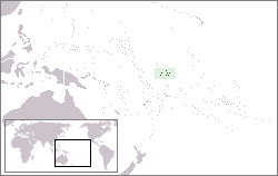
The Indispensable Reefs are a chain of three large coral atolls in the Coral Sea. They are located about 50 km (30 mi) south of Rennell Island, separated from it by Rennel Trough. The chain stretches over a length of 114 km (71 mi) and its average width is 18 km (11 mi).
Tema Reef, also called Tima Reef, is a submerged coral reef in the northern island group of the Cook Islands, 23 kilometres southeast of Pukapuka.
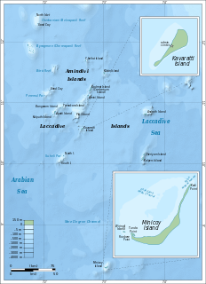
Kadmat Island, also known as Cardamom Island, is a coral island belonging to the Amindivi subgroup of islands of the Lakshadweep archipelago in India. Measuring 9.3 kilometres (5.8 mi) in length, the island has a lagoon with a width of 1.5 kilometres (0.93 mi) covering an area of 25 square kilometres (9.7 sq mi). The ecological feature of the island is of coral reef with seagrass, and marine turtles which nestle here. The Ministry of Environment and Forests (India) has notified the island as a marine protected area for ensuring conservation of the island's animal, plant, or other type of organism, and other resources.

Isla Magueyes is a 7.2 hectares island 50 metres (160 ft) from the southwest coast of the island of Puerto Rico. It is encircled with mangrove and has an interior of dry scrub habitat, where it gets its name. It is named for the presence of many century plants or maguey. The surrounding shelf of the island is mostly coral reef. There are buildings on the western end of the island associated with the Department of Marine Sciences, University of Puerto Rico at Mayagüez. UPR- Mayagüez is an important center in the Atlantic region for the study of tropical marine science due to its location, facilities, and first-rate researchers. The research facilities includes the Puerto Rico Water Resources and Environmental Research Institute, the Caribbean Coral Reef Institute (CCRI), the Research and Development Center, the Agricultural Research Station and the Caribbean Atmospheric Research Center (ATMOSCarib).

The Phoenix Islands Protected Area (PIPA) is located in the Republic of Kiribati, an ocean nation in the central Pacific approximately midway between Australia and Hawaii. PIPA constitutes 11.34% of Kiribati's exclusive economic zone (EEZ), and with a size of 408,250 km2 (157,630 sq mi), it is one of the largest marine protected areas (MPA) and one of the largest protected areas of any type on Earth. The PIPA was also designated as the world's largest and deepest UNESCO World Heritage Site in 2010.

The Menai Bay Conservation Area (MBCA) is located in Menai Bay, Zanzibar Tanzania. At 470 square kilometres (180 sq mi), it is Zanzibar's largest marine protected area. It was officially established as a conservation area in August 1997 in the traditional fishing area, known as Unguja Island, covering the tropical marine environment comprising extensive coral reefs, tropical fish, sea grasses, and mangrove forests. In addition to controlling illegal fishing, MBCA's alternative initiatives have included bee keeping, mangrove replanting, tree nurseries and tourism. The management of the MBCA falls upon the Fisheries Department and the bay's local villages. It is rated by the IUCN as Category VI Managed Resource Protected Area.

Mu Ko Chang National Park is in Trat Province, eastern Thailand. It spans several provincial districts. It is a marine national park with an area of 650 square kilometres (250 sq mi), including 52 islands. The most notable island within the archipelago is Ko Chang. Ko Chang covers an area of 212.947 km2 and is the major island in the Mu Ko Chang National Park, which became Thailand's 45th National Park in 1982. The park is an IUCN Category II protected area with coral reefs.

Hat Noppharat Thara–Mu Ko Phi Phi National Park lies in the Ao Nang, Sai Thai, and Pak Nam Sub-districts of Amphoe Mueang Krabi, Krabi Province, Thailand. It is a marine national park. Established in 1983, it is an IUCN Category II protected area with coral reefs, and an area measuring 387.9 square kilometres (149.8 sq mi).

Hat Chao Mai National Park is a protected area located in the Sikao and Kantang Districts of Trang Province, Thailand. It is a marine national park. Established in 1981, it is an IUCN Category II protected area with coral reefs, and an area measuring 230.86 square kilometres (89.14 sq mi). The park has been designated as a Ramsar site since 2002.
Coral diseases, comprising the diseases that affect corals, injure the living tissues and often result in the death of part or the whole of the colony. These diseases have been occurring more frequently in the twenty-first century as conditions become more stressful for many shallow-water corals. The pathogens causing the diseases include bacteria, fungi and protozoa, but it is not always possible to identify the pathogen involved.

The Coral reefs of Kiribati consists of 32 atolls and one raised coral island, Banaba, which is an isolated island between Nauru and the Gilbert Islands. The islands of Kiribati are dispersed over 3.5 million km2 (1.4 million sq mi) of the Pacific Ocean and straddle the equator and the 180th meridian, extending into the eastern and western hemispheres, as well as the northern and southern hemispheres. 21 of the 33 islands are inhabited. The groups of islands of Kiribati are:
References
| Northern chain | ||
|---|---|---|
| Southern chain - Nga-pu-Toru | ||
| Southern chain - other | ||
| | This Cook Islands location article is a stub. You can help Wikipedia by expanding it. |