
The Tlingit or Lingít are Indigenous peoples of the Pacific Northwest Coast of North America and constitute two of the 231 federally recognized Tribes of Alaska. Most Tlingit are Alaska Natives; however, some are First Nations in Canada.

Northern Canada, colloquially the North or the Territories, is the vast northernmost region of Canada, variously defined by geography and politics. Politically, the term refers to the three territories of Canada: Yukon, Northwest Territories and Nunavut. This area covers about 48 per cent of Canada's total land area, but has less than 0.5 per cent of Canada's population.

The Coast Mountains are a major mountain range in the Pacific Coast Ranges of western North America, extending from southwestern Yukon through the Alaska Panhandle and virtually all of the Coast of British Columbia south to the Fraser River. The mountain range's name derives from its proximity to the sea coast, and it is often referred to as the Coast Range. The range includes volcanic and non-volcanic mountains and the extensive ice fields of the Pacific and Boundary Ranges, and the northern end of the volcanic system known as the Cascade Volcanoes. The Coast Mountains are part of a larger mountain system called the Pacific Coast Ranges or the Pacific Mountain System, which includes the Cascade Range, the Insular Mountains, the Olympic Mountains, the Oregon Coast Range, the California Coast Ranges, the Saint Elias Mountains and the Chugach Mountains. The Coast Mountains are also part of the American Cordillera—a Spanish term for an extensive chain of mountain ranges—that consists of an almost continuous sequence of mountain ranges that form the western backbone of North America, Central America, South America and Antarctica.

The North-Western Territory was a region of British North America extant until 1870 and named for where it lay in relation to Rupert's Land.

Oregon Country was a large region of the Pacific Northwest of North America that was subject to a long dispute between the United Kingdom and the United States in the early 19th century. The area, which had been demarcated by the Treaty of 1818, consisted of the land north of 42° N latitude, south of 54°40′ N latitude, and west of the Rocky Mountains down to the Pacific Ocean and east to the Continental Divide. Article III of the 1818 treaty gave joint control to both nations for ten years, allowed land to be claimed, and guaranteed free navigation to all mercantile trade. However, both countries disputed the terms of the international treaty. Oregon Country was the American name, while the British used Columbia District for the region.
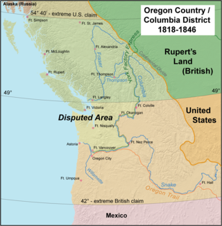
The Oregon boundary dispute or the Oregon Question was a 19th-century territorial dispute over the political division of the Pacific Northwest of North America between several nations that had competing territorial and commercial aspirations in the region.

The Beaufort Sea is a marginal sea of the Arctic Ocean, located north of the Northwest Territories, Yukon, and Alaska, and west of the Canadian Arctic Archipelago. The sea is named after Sir Francis Beaufort, a hydrographer. The Mackenzie River, the longest in Canada, empties into the Canadian part of the Beaufort Sea west of Tuktoyaktuk, which is one of the few permanent settlements on the sea's shores.

The Alaska boundary dispute was a territorial dispute between the United States and the United Kingdom of Great Britain and Ireland, which then controlled Canada's foreign relations. It was resolved by arbitration in 1903. The dispute had existed between the Russian Empire and Britain since 1821, and was inherited by the United States as a consequence of the Alaska Purchase in 1867. The final resolution favored the American position, as Canada did not get an all-Canadian outlet from the Yukon gold fields to the sea. The disappointment and anger in Canada was directed less at the United States, and more at the British government for betraying Canadian interests in favor of healthier Anglo-American relations.

The Stikine River is a major river in northern British Columbia (BC), Canada and southeastern Alaska in the United States. It drains a large, remote upland area known as the Stikine Country east of the Coast Mountains. Flowing west and south for 610 kilometres (379 mi), it empties into various straits of the Inside Passage near Wrangell, Alaska. About 90 percent of the river's length and 95 percent of its drainage basin are in Canada. Considered one of the last truly wild large rivers in BC, the Stikine flows through a variety of landscapes including boreal forest, steep canyons and wide glacial valleys.

The Stickeen Territories, also colloquially rendered as Stickeen Territory,Stikine Territory, and Stikeen Territory, was a territory of British North America whose brief existence began July 19, 1862, and concluded July of the following year. The region was split from the North-Western Territory in the wake of the Stikine Gold Rush. The initial strike attracted large numbers of miners — mostly American — to the region; by detaching the region from the exclusive trade zone of the Hudson's Bay Company, British authorities were able to impose tariffs and licences on the speculators. The new territory, named after the Stikine River, was under the responsibility of the Governor of the Colony of British Columbia, James Douglas, who was appointed "Administrator of the Stickeen Territories" and under British law, within the jurisdiction of the Supreme Court of British Columbia.
The Russo-American Treaty of 1824 was signed in St. Petersburg between representatives of Russia and the United States on April 17, 1824, ratified by both nations on January 11, 1825 and went into effect on January 12, 1825. The accord contained six articles. It gave Russian claims on the Pacific Northwest coast of North America south of parallel 54°40′ north to the United States.

The Columbia District was a fur-trading district in the Pacific Northwest region of North America, in both the United States and British North America in the 19th century. Much of its territory overlapped with the temporarily jointly occupied and disputed Oregon Country. It was explored by the North West Company between 1793 and 1811 and established as an operating fur-trading district around 1810. The North West Company was absorbed into the Hudson's Bay Company (HBC) in 1821, under which the Columbia District became known as the Columbia Department. It was considered part of British North America and later became the brief first Colony of British Columbia (1858–1866) with the subsequent merger with the Colony of Vancouver Island (1849–1866) to form a larger second short-lived Colony of British Columbia (1866–1871). After protracted negotiations with British and Canadian authorities, the newly reorganized Province of British Columbia joined in 1871 with the new Canadian confederation of 1867 further east, as the western-most province of the now trans-continental Dominion of Canada. The Oregon Treaty of June 1846, signed in Washington, D.C., by the United States and the United Kingdom, marked the effective end of the old Hudson's Bay Company's jurisdiction of the former western Columbia District / Department on the Pacific coast, although the HBC still continues a mercantile commercial business into the 21st century.

The Boundary Ranges, also known in the singular and as the Alaska Boundary Range, are the largest and most northerly subrange of the Coast Mountains. They begin at the Nass River, near the southern end of the Alaska Panhandle in the Canadian province of British Columbia and run to the Kelsall River, near the Chilkoot Pass, beyond which are the Alsek Ranges of the Saint Elias Mountains, and northwards into the Yukon Territory flanking the west side of the Yukon River drainage as far as Champagne Pass, north of which being the Yukon Ranges. To their east are the Skeena Mountains and Stikine Plateau of the Interior Mountains complex that lies northwest of the Interior Plateau; the immediately adjoining subregion of the Stikine Plateau is the Tahltan Highland. To their northeast is the Tagish Highland, which is a subregion of the Yukon Plateau. Both highlands are considered in some descriptions as included in the Coast Mountains. The Alexander Archipelago lies offshore and is entirely within Alaska.

The Stikine Country, also referred to as the Stikine District or simply "the Stikine", is one of the historical geographic regions of the Canadian province of British Columbia, located inland from the central Alaska Panhandle and comprising the basin of the Stikine River and its tributaries. The term Stikine–Iskut is also fairly common to describe the area, and references the Iskut River, the Stikine's largest tributary and describable as its south fork.

Wales Island is an island on the North Coast of British Columbia, Canada, situated east of the Dixon Entrance at the entrance to Portland Inlet.
Fort Durham, also known as Fort Taku, Taku, Taco, and Tacouw, is an archaeological site near Taku Harbor, Alaska, within the limits of Juneau City and Borough and Tongass National Forest. It was one of three Hudson's Bay Company (HBC) posts set up in Russian America. The Fort Durham Site was declared a U.S. National Historic Landmark in 1978.
Mount Nesselrode, also known as Boundary Peak 98, is a 2,474 m (8,117 ft) peak in the Boundary Ranges of the Coast Mountains, located on and in part defining the border between British Columbia, Canada, and Alaska, United States. About 40 miles (64 km) north of Juneau to the west of the lower Stikine River and in the heart of the Stikine Icecap in Juneau Icefield southwest of Atlin Lake, the summit, with a prominence of 924 m (3,031 ft), is also the corner point of Alaska's Haines Borough and Juneau Borough.
Fort Stikine was a fur trade post and fortification in what is now the Alaska Panhandle, at the site of the present-day of Wrangell, Alaska. Originally built as the Redoubt San Dionisio or Redoubt Saint Dionysius in 1834, the site was transferred to the British-owned Hudson's Bay Company as part of a lease signed in the region in 1838, and renamed Fort Stikine when turned into a Hudson's Bay Company post in 1839. The post was closed and decommissioned by 1843 but the name remained for the large village of the Stikine people which had grown around it, becoming known as Shakesville in reference to its ruling Chief Shakes by the 1860s. With the Alaska Purchase of 1867, the fortification became occupied by the US Army and was renamed Fort Wrangel, a reference to Baron von Wrangel, who had been Governor of Russian America when the fort was founded. The site today is now part of the city of Wrangell.
RAC–HBC Agreement was a series of protocols signed by the Russian-American Company (RAC) and the Hudson's Bay Company (HBC) in 1839 and remained active until 1865.
