
The geography of Alabama describes a state in the Southeastern United States in North America. It extends from high mountains to low valleys and sandy beaches. Alabama is 30th in size and borders four U.S. states: Mississippi, Tennessee, Georgia, and Florida. It also borders the Gulf of Mexico.

Interstate 75 (I-75) is a major north–south Interstate Highway in the Great Lakes and Southeastern regions of the United States. As with most Interstates that end in 5, it is a major cross-country, north–south route, traveling from State Road 826 and SR 924 on the Hialeah–Miami Lakes border to Sault Ste. Marie, Michigan, at the Canadian border. It is the second-longest north–south Interstate Highway and the seventh-longest Interstate Highway overall.

Interstate 24 (I-24) is an Interstate Highway in the Midwestern and Southeastern United States. It runs diagonally from I-57, 10 miles (16 km) south of Marion, Illinois, to Chattanooga, Tennessee, at I-75. It travels through Illinois, Kentucky, Tennessee, and Georgia. As an even-numbered Interstate, it is signed as an east–west route, though the route follows a more southeast–northwest routing, passing through Nashville, Tennessee. The numbering deviates from the standard Interstate Highway System grid, lying further north than its number would indicate west of Nashville. The short segment within Georgia bears the unsigned designation State Route 409 (SR 409).

Interstate 59 (I-59) is an Interstate Highway located in the southeastern United States. It is a north–south route that spans 445.23 miles (716.53 km) from a junction with I-10 and I-12 at Slidell, Louisiana, to a junction with I-24 near Wildwood, Georgia.

Walker County is a county located in the northwestern part of the U.S. state of Georgia. As of the 2020 census, the population was 67,654, down from 68,756 in 2010. The county seat is LaFayette. The county was created on December 18, 1833, from land formerly belonging to the Cherokee Indian Nation.

Monteagle is a town in Franklin, Grundy, and Marion counties in the U.S. state of Tennessee, in the Cumberland Plateau region of the southeastern part of the state. The population was 1,238 at the 2000 census – 804 of the town's 1,238 residents (64.9%) lived in Grundy County, 428 (34.6%) in Marion County, and 6 (0.5%) in Franklin County. The population at the 2020 census was 1,393.

U.S. Route 27 (US 27) is a north–south United States Highway in the southern and midwestern United States. The southern terminus is at US 1 in Miami, Florida. The northern terminus is at Interstate 69 (I-69) in Fort Wayne, Indiana. From Miami it goes up the center of Florida, then west to Tallahassee, Florida, and north through such cities and towns as Columbus, Georgia; Rome, Georgia; Chattanooga, Tennessee; Lexington, Kentucky; Cincinnati, Ohio; Oxford, Ohio; Richmond, Indiana; and Fort Wayne, Indiana. It once extended north through Lansing, Michigan, to Cheboygan, Mackinaw City, and for about three years even as far as St. Ignace. US 27 was first signed in 1926, replacing what had been the eastern route of the Dixie Highway in many states.

The Cumberland Plateau is the southern part of the Appalachian Plateau in the Appalachian Mountains of the United States. It includes much of eastern Kentucky and Tennessee, and portions of northern Alabama and northwest Georgia. The terms "Allegheny Plateau" and the "Cumberland Plateau" both refer to the dissected plateau lands lying west of the main Appalachian Mountains. The terms stem from historical usage rather than geological difference, so there is no strict dividing line between the two. Two major rivers share the names of the plateaus, with the Allegheny River rising in the Allegheny Plateau and the Cumberland River rising in the Cumberland Plateau in Harlan County, Kentucky.

East Tennessee is one of the three Grand Divisions of Tennessee defined in state law. Geographically and socioculturally distinct, it comprises approximately the eastern third of the U.S. state of Tennessee. East Tennessee consists of 33 counties, 30 located within the Eastern Time Zone and three counties in the Central Time Zone, namely Bledsoe, Cumberland, and Marion. East Tennessee is entirely located within the Appalachian Mountains, although the landforms range from densely forested 6,000-foot (1,800 m) mountains to broad river valleys. The region contains the major cities of Knoxville and Chattanooga, Tennessee's third and fourth largest cities, respectively, and the Tri-Cities, the state's sixth largest population center.

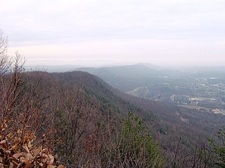
Lookout Mountain is a mountain ridge located at the northwest corner of the U.S. state of Georgia, the northeast corner of Alabama, and along the southeastern Tennessee state line in Chattanooga. Lookout Mountain was the scene of the 18th-century "Last Battle of the Cherokees" in this area during the Nickajack Expedition. On November 24, 1863, during the American Civil War, the Battle of Lookout Mountain took place here.

U.S. Route 72 (US 72) is an east–west United States highway that travels for 317.811 miles (511.467 km) from southwestern Tennessee, throughout North Mississippi, North Alabama, and southeastern Tennessee. The highway's western terminus is in Memphis, Tennessee and its eastern terminus is in Chattanooga. It is the only U.S. Highway to begin and end in the same state, yet pass through other states in between. Prior to the U.S. Highway system signage being posted in 1926, the entire route was part of the Lee Highway.

The Sequatchie River is a 116-mile-long (187 km) waterway that drains the Sequatchie Valley, a large valley in the Cumberland Plateau in Tennessee. It empties into the Tennessee River downstream from Chattanooga near the Tennessee-Alabama state line.
North and South Chickamauga Creek are short tributaries of the Tennessee River which join it near Chattanooga, Tennessee on the north and the south. West Chickamauga Creek is a much longer tributary of South Chickamauga Creek.

The Tennessee Valley is the drainage basin of the Tennessee River and is largely within the U.S. state of Tennessee. It stretches from southwest Kentucky to north Alabama and from northeast Mississippi to the mountains of Virginia and North Carolina. The border of the valley is known as the Tennessee Valley Divide. The Tennessee Valley contributes greatly to the formation of Tennessee's three legally recognized sectors.

The Tennessee, Alabama and Georgia Railroad was created through a reorganization of the Chattanooga Southern Railway in 1911. A few years later, in 1922, the line's name was changed to the Tennessee, Alabama and Georgia Railway and was also known as the TAG Route. The TAG ran from Chattanooga, Tennessee, through northwest Georgia, and into Gadsden, Alabama. The trackage began at Milepost 1 in Alton Park (Chattanooga) and continued southwest to the southern terminus in Gadsden, some 91.7 miles (147.6 km) distant. In 1952, the railroad retired its last steam locomotive.

Sand Mountain is a sandstone plateau in northeastern Alabama and northwestern Georgia and southeastern Tennessee where the plateau is known as Raccoon Mountain and Elder Mountain. It is part of the southern tip of the Appalachian mountain chain and it is the largest plateau in the chain. Geologically a continuation of Walden Ridge, Sand Mountain is part of the Cumberland Plateau, separated from the main portion of the plateau by the Tennessee River and Sequatchie Valley. The average elevation on Sand Mountain is around 1,500 feet (460 m) above sea level, compared to about 650 feet (200 m) in the surrounding area. This elevation leads to its having the coolest climate in the state of Alabama. The largest city on Sand Mountain is Albertville, in Marshall County. As of the 2020 census, the population of the city was 22,386.
The Highway 127 Corridor Sale, also called the 127 Yard Sale, is an outdoor second-hand sale held annually for four days beginning the first Thursday in August along U.S. Route 127 (US 127). The event has been promoted as "The World's Longest Yard Sale."
Walden Ridge is a mountain ridge and escarpment located in Tennessee, in the United States. It marks the eastern edge of the Cumberland Plateau and is generally considered part of it. Walden Ridge is about 74 miles (119 km) long, running generally north-south. Its highest point is at Hinch Mountain, which reaches 3,048 feet (929 m) above sea level. Sometimes Walden Ridge is called the Cumberland Escarpment.

U.S. Route 11 (US 11) in the U.S. state of Georgia is a 22.8-mile-long (36.7 km) United States Numbered Highway that travels north–south through Dade County in the northwestern part of the state. It runs concurrently with State Route 58 (SR 58) for its entire length. In Georgia, the southern end is at the Alabama state line near Rising Fawn, and the northern end at the Tennessee state line at Chattanooga, Tennessee.

State Route 156 is a spur route of Tennessee State Route 56 (SR 56) and a state highway in Franklin and Marion counties in the southern central and southeastern portions of Tennessee, United States. It traverses the southern Cumberland Plateau before descending into the Sequatchie Valley, where follows the shores of Nickajack Lake for its final few miles.