Related Research Articles

Sedimentary rocks are types of rock that are formed by the accumulation or deposition of mineral or organic particles at Earth's surface, followed by cementation. Sedimentation is the collective name for processes that cause these particles to settle in place. The particles that form a sedimentary rock are called sediment, and may be composed of geological detritus (minerals) or biological detritus. The geological detritus originated from weathering and erosion of existing rocks, or from the solidification of molten lava blobs erupted by volcanoes. The geological detritus is transported to the place of deposition by water, wind, ice or mass movement, which are called agents of denudation. Biological detritus was formed by bodies and parts of dead aquatic organisms, as well as their fecal mass, suspended in water and slowly piling up on the floor of water bodies. Sedimentation may also occur as dissolved minerals precipitate from water solution.
Sedimentology encompasses the study of modern sediments such as sand, silt, and clay, and the processes that result in their formation, transport, deposition and diagenesis. Sedimentologists apply their understanding of modern processes to interpret geologic history through observations of sedimentary rocks and sedimentary structures.

An evaporite is a water-soluble sedimentary mineral deposit that results from concentration and crystallization by evaporation from an aqueous solution. There are two types of evaporite deposits: marine, which can also be described as ocean deposits, and non-marine, which are found in standing bodies of water such as lakes. Evaporites are considered sedimentary rocks and are formed by chemical sediments.

An alluvial fan is an accumulation of sediments that fans outwards from a concentrated source of sediments, such as a narrow canyon emerging from an escarpment. They are characteristic of mountainous terrain in arid to semiarid climates, but are also found in more humid environments subject to intense rainfall and in areas of modern glaciation. They range in area from less than 1 square kilometer (0.4 sq mi) to almost 20,000 square kilometers (7,700 sq mi).

An endorheic basin is a drainage basin that normally retains water and allows no outflow to other external bodies of water ; instead, the water drainage flows into permanent and seasonal lakes and swamps that equilibrate through evaporation. Endorheic basins are also called closed basins, terminal basins, and internal drainage systems.

Natural salt pans or salt flats are flat expanses of ground covered with salt and other minerals, usually shining white under the sun. They are found in deserts and are natural formations.

Aeolian processes, also spelled eolian, pertain to wind activity in the study of geology and weather and specifically to the wind's ability to shape the surface of the Earth. Winds may erode, transport, and deposit materials and are effective agents in regions with sparse vegetation, a lack of soil moisture and a large supply of unconsolidated sediments. Although water is a much more powerful eroding force than wind, aeolian processes are important in arid environments such as deserts.

Conglomerate is a sedimentary rock made up of rounded gravel-sized pieces of rock surrounded by finer-grained sediments. The larger fragments within conglomerate are called clasts, while the finer sediment surrounding the clasts is called the matrix. The clasts and matrix are typically cemented by calcium carbonate, iron oxide, silica, or hardened clay.
Sequence stratigraphy is a branch of geology, specifically a branch of stratigraphy, that attempts to discern and understand historic geology through time by subdividing and linking sedimentary deposits into unconformity bounded units on a variety of scales. The essence of the method is mapping of strata based on identification of surfaces which are assumed to represent time lines, thereby placing stratigraphy in chronostratigraphic framework allowing understanding of the evolution of the Earth's surface in a particular region through time. Sequence stratigraphy is a useful alternative to a purely lithostratigraphic approach, which emphasizes solely based on the compositional similarity of the lithology of rock units rather than time significance. Unconformities are particularly important in understanding geologic history because they represent erosional surfaces where there is a clear gap in the record. Conversely within a sequence the geologic record should be relatively continuous and complete record that is genetically related.
In the Messinian salinity crisis the Mediterranean Sea went into a cycle of partial or nearly complete desiccation (drying-up) throughout the latter part of the Messinian age of the Miocene epoch, from 5.96 to 5.33 Ma. It ended with the Zanclean flood, when the Atlantic reclaimed the basin.

A lacustrine plain or lake plain is a plain formed due to the past existence of a lake and its accompanying sediment accumulation. Lacustrine plains can be formed through one of three major mechanisms: glacial drainage, differential uplift, and inland lake creation and drainage. Lake plains can have various uses depending on where and how they form.

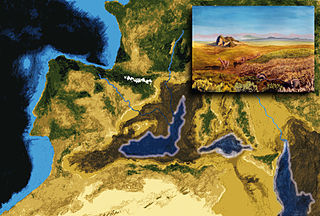
Chott el Djerid also spelled Sciott Gerid and Shott el Jerid, is a chott, a large endorheic salt lake in southern Tunisia. The name can be translated from the Arabic into English as "Lagoon of the Land of Palms".

A sabkha is a coastal, supratidal mudflat or sandflat in which evaporite-saline minerals accumulate as the result of semiarid to arid climate. Sabkhas are gradational between land and intertidal zone within restricted coastal plains just above normal high-tide level. Within a sabkha, evaporite-saline minerals sediments typically accumulate below the surface of mudflats or sandflats. Evaporite-saline minerals, tidal-flood, and aeolian deposits characterize many sabkhas found along modern coastlines. The accepted type locality for a sabkha is at the southern coast of the Persian Gulf, in the United Arab Emirates. Evidence of clastic sabkhas are found in the geological record of many areas, including the UK and Ireland. Sabkha is a phonetic transliteration of the Arabic word used to describe any form of salt flat. A sabkha is also known as a sabkhah,sebkha, or coastal sabkha.

In geology, depositional environment or sedimentary environment describes the combination of physical, chemical, and biological processes associated with the deposition of a particular type of sediment and, therefore, the rock types that will be formed after lithification, if the sediment is preserved in the rock record. In most cases, the environments associated with particular rock types or associations of rock types can be matched to existing analogues. However, the further back in geological time sediments were deposited, the more likely that direct modern analogues are not available.

Olympia Undae is a vast dune field in the north polar region of the planet Mars. It consists of a broad "sand sea" or erg that partly rings the north polar plateau from about 120° to 240°E longitude and 78° to 83°N latitude. Stretching about 1,100 km (680 mi) across and covering an area of 470,000 km2, Olympia Undae is the largest continuous dune field on Mars. It is similar in size to the Rub' Al Khali in the Arabian Peninsula, the largest active erg on Earth.

Rain and snow were regular occurrences on Mars in the past; especially in the Noachian and early Hesperian epochs. Water was theorized to seep into the ground until it reached a formation that would not allow it to penetrate further. Water then accumulated forming a saturated layer. Deep aquifers may still exist.
Chott el Fejej, also known as Chott el Fedjedj and Chott el Fejaj, is a long, narrow inlet of the endorheic salt lake Chott el Djerid in southern Tunisia.

Salt surface structures are extensions of salt tectonics that form at the Earth's surface when either diapirs or salt sheets pierce through the overlying strata. They can occur in any location where there are salt deposits, namely in cratonic basins, synrift basins, passive margins and collisional margins. These are environments where mass quantities of water collect and then evaporate; leaving behind salt and other evaporites to form sedimentary beds. When there is a difference in pressure, such as additional sediment in a particular area, the salt beds – due to the unique ability of salt to behave as a fluid under pressure – form into new structures. Sometimes, these new bodies form subhorizontal or moderately dipping structures over a younger stratigraphic unit, which are called allochthonous salt bodies or salt surface structures.

In summer 1965, the first close-up images from Mars showed a cratered desert with no signs of water. However, over the decades, as more parts of the planet were imaged with better cameras on more sophisticated satellites, Mars showed evidence of past river valleys, lakes and present ice in glaciers and in the ground. It was discovered that the climate of Mars displays huge changes over geologic time because its axis is not stabilized by a large moon, as Earth's is. Also, some researchers maintain that surface liquid water could have existed for periods of time due to geothermal effects, chemical composition, or asteroid impacts. This article describes some of the places that could have held large lakes.

Equatorial layered deposits (ELD’s) have been called interior layered deposits (ILDs) in Valles Marineris. They are often found with the most abundant outcrops of hydrated sulfates on Mars, and thus are likely to preserve a record of liquid water in Martian history since hydrated sulfates are formed in the presence of water. Layering is visible on meter scale, and when the deposits are partly eroded, intricate patterns become visible. The layers in the mound in Gale Crater have been extensively studied from orbit by instruments on the Mars Reconnaissance Orbiter. The Curiosity Rover landed in the crater, and it has brought some ground truth to the observations from satellites. Many of the layers in ELD’s such as in Gale Crater are composed of fine-grained, easily erodible material as are many other layered deposits. On the basis of albedo, erosion patterns, physical characteristics, and composition, researchers have classified different groups of layers in Gale Crater that seem to be similar to layers in other (ELD’s). The groups include: a small yardang unit, a coarse yardang unit, and a terraced unit. Generally, equatorial layered deposits are found ~ ±30° of the equator. Equatorial Layered Deposits appear in various geological settings such as cratered terrains, chaotic terrains, the Valles Marineris chasmata, and large impact craters.
References
- ↑ Swezey, C.S., 2003, The role of climate in the creation and destruction of continental stratigraphic records: An example from the northern margin of the Sahara Desert, in Cecil, C.B., and Edgar, N.T., eds., Climate Controls on Stratigraphy: SEPM (Society for Sedimentary Geology) Special Publication 77, p. 207-225.
- ↑ Ramdani, Mohammed; Elkhiat, Najat; Flower, Roger J (2010). "Africa: North of Sahara". In Likens, Gene E. (ed.). Encyclopedia of Inland Waters. Vol. Lake Ecosystem Ecology. San Diego, CA: Academic Press. ISBN 978-0123820020 . Retrieved 16 December 2012.
- 1 2 3 Laity, Julie J. (2009). Deserts and Desert Environments. Environmental Systems and Global Change Series. Chichester, UK: John Wiley & Sons. ISBN 978-1444300741 . Retrieved 16 December 2012.
- 1 2 Komatsu, Goro; Ori, Gian Gabriele; Marinangeli, Lucia; Moersch, Jeffrey E. (2007). "Playa environments on Earth: Possible analogs for Mars". In Chapman, Mary (ed.). The Geology of Mars: Evidence from Earth-Based Analogs (5th ed.). Chichester, UK: Cambridge University Press. ISBN 978-0521832922 . Retrieved 16 December 2012.
- ↑ Spinage, Clive Alfred (2012). African Ecology: Benchmarks and Historical Perspectives. Springer Geography (Illustrated ed.). New York: Springer. ISBN 978-3642228711 . Retrieved 16 December 2012.