The Antofagasta Region is one of Chile's sixteen first-order administrative divisions. Being the second-largest region of Chile in area, it comprises three provinces, Antofagasta, El Loa and Tocopilla. It is bordered to the north by Tarapacá, by Atacama to the south, and to the east by Bolivia and Argentina. The region's capital is the port city of Antofagasta; another one of its important cities is Calama. The region's main economic activity is copper mining in its giant inland porphyry copper systems.
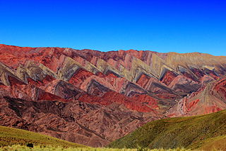
Jujuy is a province of Argentina, located in the extreme northwest of the country, at the borders with Chile and Bolivia. The only neighboring Argentine province is Salta to the east and south.

San Pedro de Atacama is a Chilean town and commune in El Loa Province, Antofagasta Region. It is located east of Antofagasta, some 106 km (60 mi) southeast of Calama and the Chuquicamata copper mine, overlooking the Licancabur volcano. It features a significant archeological museum, the R. P. Gustavo Le Paige Archaeological Museum, with a large collection of relics and artifacts from the region. Native ruins nearby attract increasing numbers of tourists interested in learning about pre-Columbian cultures.

Salar de Atacama, located 55 km (34 mi) south of San Pedro de Atacama, is the largest salt flat in Chile. It is surrounded by mountains and lacks drainage outlets. To the east, it is enclosed by the main chain of the Andes, while to the west lies a secondary mountain range called Cordillera de Domeyko. The landscape is dominated by imposing volcanoes such as Licancabur, Acamarachi, Aguas Calientes, and Láscar, the latter being one of Chile's most active volcanoes. These volcanoes are situated along the eastern side of the Salar de Atacama, forming a north–south trending line that separates it from smaller endorheic basins.

Los Flamencos National Reserve is a nature reserve located in the commune of San Pedro de Atacama, Antofagasta Region of northern Chile. The reserve covers a total area of 740 square kilometres (290 sq mi) in the Central Andean dry puna ecoregion and consists of seven separate sections.

Pular is a volcanic massif in the Chilean Andes, north of Socompa volcano. It consists of the individual mountains Pajonales and Pular, which are among the highest mountains in the region and of great cultural importance to the neighbouring towns of Socaire and Peine. Pular and Pajonales have multiple volcanic craters and have produced lava domes. The mountains were active during the last three million years; whether there was any activity in historical times is unclear. The mountains are largely unglaciated in the present, owing to the dry climate, although groundwater originates on them. During the last glacial maximum, glacial advances took place and left a girdle of moraines around the massif.
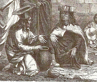
The Atacama people, also called Atacameño, are an Indigenous people from the Atacama Desert and altiplano region in the north of Chile and Argentina and southern Bolivia, mainly the Antofagasta Region.

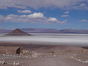
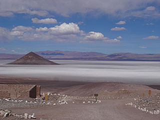
Salar de Talar is a 46 square kilometres salt flat located in the high puna of northern Chilean Andes, at an altitude of 3,950 m. It is part of a series of salt lakes and salt flats located at the foothills of a chain of volcanoes stretching along the eastern side of the much greater Salar de Atacama.

The Puna de Atacama or Atacama Plateau is an arid high plateau, in the Andes of northern Chile (15%) and northwest of Argentina (85%). Geomorphologist Walther Penck based his Grossfalt landform association on Puna de Atacama.
Salar de Pedernales is a large salt flat in the Atacama Region of Chile. It lies east of the Cordillera Domeyko at an elevation of 3,370 metres (11,060 ft). The salt flat has an irregular shape and consists mostly of gypsum and rock salt, with an area of 0.6 square kilometres (0.23 sq mi)-1.1 square kilometres (0.42 sq mi) covered by open water. During the late Pleistocene, the climate was wetter and thus open water covered a much larger area of Salar de Pedernales.

Tolar Grande is a village and rural municipality in Salta Province in northwestern Argentina.

Los Andes is a department located in Salta Province, Argentina. It is the second largest by area in the province, after Rivadavia Department, and its capital is the town of San Antonio de los Cobres.

La Poma is a department located in Salta Province, Argentina. It is the least populated department of the province and its capital is the town of La Poma.

The Salta–Antofagasta railway, also named Huaytiquina, is a non-electrified single track railway line that links Argentina and Chile passing through the Andes. It is a 1,000 mmmetre gauge railway with a total length of 941 km, connecting the city of Salta (Argentina) to the one of Antofagasta (Chile), on the Pacific Ocean, passing through the Puna de Atacama and Atacama Desert.
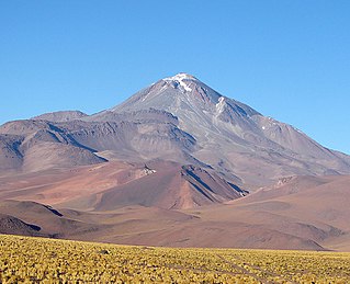
Llullaillaco is a dormant stratovolcano on the border between Argentina and Chile. It lies in the Puna de Atacama, a region of tall volcanic peaks on a high plateau close to the Atacama Desert, one of the driest places in the world. Its maximum elevation is most commonly given as 6723 m, making it the second- or third-highest volcano in the world. Despite its height, it is not clear whether the volcano has any glaciers or merely patches of perennial snow and ice. Between 3700 m and 5000 m elevation there is a sparse plant cover, while at lower altitudes the climate is too dry for plants to grow. A species of mouse on Llullaillaco is the highest-living known vertebrate species.

Antofalla is a Miocene-Pliocene volcano in Argentina's Catamarca Province. It is part of the volcanic segment of the Andes in Argentina, and it is considered to be part of the Central Volcanic Zone, one of the volcanic zones of the Andes. Antofalla forms a group of volcanoes that are aligned on and behind the main volcanic arc. Antofalla itself is a remote volcano.
Arizaro volcanic field is a group of volcanoes west of the Salar de Arizaro.

Salar del Hombre Muerto is a salt pan in Argentina, in the Antofagasta de la Sierra Department on the border between the Salta and Catamarca Provinces. It covers an area of 600 square kilometres (230 sq mi) and is in part covered by debris. During the Pleistocene it was sometimes a lake, but today only parts of the salt pan are covered by perennial water bodies; its major tributary is the Río de los Patos.
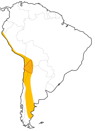
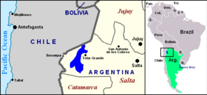
The Lithium Triangle is a region of the Andes that is rich in lithium reserves, encompassed by the borders of Argentina, Bolivia, and Chile. The lithium in the triangle is concentrated in various salt pans that exist along the Atacama Desert and neighboring arid areas. The largest areas three main salt pans that define its vertices are the Salar de Uyuni in Bolivia, Salar de Atacama in Chile, and Salar del Hombre Muerto in Argentina. Of these, the core of Salar de Atacama in Chile has the highest concentration of lithium among all world's brine sources.
The Geste Formation is a fossiliferous geologic formation of the Puna Plateau in the western Salta Province and northern Catamarca Province of the Argentine Northwest, northwestern Argentina.