Salar del Hombre Muerto (transl. Salt Pan of the Dead Man) is a salt pan in Argentina, in the Antofagasta de la Sierra Department [2] on the border between the Salta and Catamarca Provinces. [3] It covers an area of 600 square kilometres (230 sq mi) and is in part covered by debris. During the Pleistocene it was sometimes a lake, but today only parts of the salt pan are covered by perennial water bodies; its major tributary is the Río de los Patos.
Part of the Lithium Triangle of salars, Salar del Hombre Muerto is one of the world's most important sources of lithium, an element crucial for manufacturing lithium-ion batteries, which are very important in renewable energy technology and electric cars.
Salar del Hombre Muerto is a 600-kilometre (370 mi) [4] salt pan with irregular margins [5] resembling a square. To the north lies the elongated, narrow Lanja Negra or Tincalayu peninsula, while the anvil-shaped Peninsula de Hombre Muerto protrudes from the southeastern side. Between the two lies a central island named Farallon Catal [6] with an area of 72 square kilometres (28 sq mi) that separates Hombre Muerto into two halves, [7] an eastern one and a western one; [8] the eastern part (also known as Salar de Vida [8] ) is covered by debris, while the western part is covered by evaporites [9] with a polygonal surface appearance. [10] Two other islands are the Tetas de la Pachamama in the eastern and Cerro Oscuro in the southern sector of the Salar. [7] An open water body covers 65 square kilometres (25 sq mi) in the eastern part. [11] Close to Salar del Hombre Muerto lie ten potential impact craters with diameters of 90–250 metres (300–820 ft) that may have formed during the last 500,000 years [12] and certainly very recently, although they could also be collapse structures in the underlying alluvial fan. [13]
The watershed of Salar del Hombre Muerto has an area of 4,000 square kilometres (1,500 sq mi), [4] half of which is drained by the 150 kilometres (93 mi) long Rio de Los Patos; this river enters into the salar from the northeast but originates on Galán and the Eastern Cordillera south of Hombre Muerto. Another tributary is the Rio Trapiche which comes into Hombre Muerto from the south, the Valle Hombre Muerto which lies between the two [4] [10] and the Rio Ratones from the north. [11] The western side of Hombre Muerto on the other hand has only small springs. The Los Patos river has a discharge of 0.8–2 cubic metres per second (28–71 cu ft/s) and supplies a perennial lake, named Catal Lagoon, and during the rainy season large parts of the salt pan can flood. The discharge of Rio Trapiche is only about 1/9 of that of Rio de Los Patos. [5] [10] The Vega Trapiche and Vega Hombre Muerto wetlands are located on the southern margin of Hombre Muerto. [14] [7]
Salar del Hombre Muerto lies at 4,300–4,100 metres (14,100–13,500 ft) [15] elevation in the southern Puna [16] and is surrounded by mountains, including volcanoes and summits reaching elevations that exceed 5,000 metres (16,000 ft). [4] The Galán volcano lies just south of Hombre Muerto [17] and has produced large ignimbrites, [18] while 5,252 metres (17,231 ft) high [11] Cerro Ratones is located on the northeastern margin; [9] additional volcanoes and faults exist in the area of Hombre Muerto. Farther west-southwest lies the long Salar de Antofalla [19] while the Salar de Ratones and Salar de Diablillos are found north-northeast and northeast from Salar del Hombre Muerto. [6] 302 kilometres (188 mi) farther east lies the city of Salta. [4]
The terrain of the area is formed by crystalline rocks of Paleozoic age, sediments of Paleozoic to Mesozoic age and Cenozoic volcanic rocks such as the 2.2–2 million-year-old Galán. Faults dissect the area [10] and cut southward across the Salar; [7] some volcanoes are associated with them [20] and faulting continued into the Quaternary. [21] The deposition of evaporites appears to have commenced 15 million years ago, [22] perhaps at the same time as endorheic drainage developed, [23] but most of the deposits are of Quaternary age. [15] Volcanic activity also took place in the area of Hombre Muerto, with andesites from its area dated to the Pliocene and Pleistocene; one flow is only about 800,000 years old. [24]
Salar del Hombre Muerto in the past received more water. [10] From the Pleistocene to the Holocene, Salar del Hombre Muerto fluctuated between being a salt lake to being a salt-encrusted salt flat. Wet lake stages occurred during oxygen isotope stage 3 and 4 [16] and during the Last Glacial Maximum, although it was smaller than preceding lake stages, [25] with a last lake stage about 8,000 years ago; since then the climate has been dry. [16] The highstand 44,000–37,000 years ago was associated with the formation of Lake Minchin in the Altiplano. [26] The former lakes deposited lacustrine travertine in the area. [7]
A weather station was situated at Salar del Hombre Muerto between 1927 and 1931. [27] The mean temperatures range from 23 °C (73 °F) in summer to 8 °C (46 °F) in winter; the day-night variation is about 20–25 °C (36–45 °F) [9] and maximum temperatures at Salar del Hombre Muerto are about 28 °C (82 °F). [28] The climate is arid; [29] the 60–80 millimetres per year (2.4–3.1 in/year) [5] precipitation originates mainly in the Amazon and comes to the salar during summer, but winter snowfall also occurs. [4]
Algae in the perennial water surfaces draw flamingos, and bunch grass around the salar is grazed by burros and llamas [5] while copepods live in the Salar. [30] Rainbow trouts have been introduced in a stream of the area. [31] Fossil bird footprints have been found in the area as well. [32]
Climate data for Salar del Hombre Muerto (1927–1931) | |||||||||||||
---|---|---|---|---|---|---|---|---|---|---|---|---|---|
Month | Jan | Feb | Mar | Apr | May | Jun | Jul | Aug | Sep | Oct | Nov | Dec | Year |
Mean daily maximum °C (°F) | 19.6 (67.3) | 20.1 (68.2) | 17.8 (64.0) | 12.8 (55.0) | 9.9 (49.8) | 7.1 (44.8) | 6.0 (42.8) | 8.4 (47.1) | 11.2 (52.2) | 16.2 (61.2) | 17.7 (63.9) | 19.4 (66.9) | 13.9 (57.0) |
Daily mean °C (°F) | 10.9 (51.6) | 10.3 (50.5) | 8.3 (46.9) | 3.9 (39.0) | 1.8 (35.2) | −0.6 (30.9) | −2.8 (27.0) | −0.5 (31.1) | 1.1 (34.0) | 5.9 (42.6) | 7.8 (46.0) | 9.9 (49.8) | 4.7 (40.5) |
Mean daily minimum °C (°F) | 2.2 (36.0) | 0.4 (32.7) | −1.2 (29.8) | 0.5 (32.9) | −6.3 (20.7) | −8.3 (17.1) | −11.5 (11.3) | −9.4 (15.1) | −8.9 (16.0) | −4.3 (24.3) | −2.0 (28.4) | 0.3 (32.5) | −4.0 (24.8) |
Average precipitation mm (inches) | 31.4 (1.24) | 2.6 (0.10) | 1.6 (0.06) | 11.0 (0.43) | 1.0 (0.04) | 4.0 (0.16) | 7.5 (0.30) | 0.0 (0.0) | 0.0 (0.0) | 0.0 (0.0) | 0.0 (0.0) | 4.7 (0.19) | 63.8 (2.51) |
Average relative humidity (%) | 40.0 | 30.2 | 27.4 | 20.0 | 20.1 | 22.3 | 23.0 | 19.4 | 16.6 | 19.5 | 23.7 | 31.3 | 24.5 |
Source: Secretaria de Mineria [33] |
Mining activities began in the 19th century. [34] The Incahuasi gold mine lies on the Incahuasi peninsula of Salar del Hombre Muerto and is associated with two towns built in the 18th century, Nuestra Señora de Loreto de Ingaguasi and Agua Salada. [35] In the past, the area was also used as a source for obsidian; [36] obsidian from Hombre Muerto has been found in Holocene archeological sites at Antofagasta de la Sierra. [37]
The name "Salar del Hombre Muerto" means "Salt Pan of the Dead Man" [38] and may be a reference to the presence of mummies in the area. [39] More recently since the 1990s the Salar del Hombre Muerto has drawn tourists. [40] Lithium extraction began in 1996 or 1997. [41] At Salar del Hombre Muerto there is a brine processing facility, [42] an airfield [43] on the northern area of the salar [7] and a gas pipeline. [3]
As part of the "Proyecto Fénix", [44] the company Arcadium Lithium (before 2018 FMC Lithium, between 2018-2024 Livent [45] [46] ) obtains lithium from Salar del Hombre Muerto, [47] employing about 110 people [48] and producing about 22500 tons/year [49] equivalents of lithium carbonate; [50] an expansion by about 6000 tons/year was underway in 2021. [51] The lithium-rich brines may have formed through the leaching of pyroclastic rocks; [52] their total amount at Salar del Hombre Muerto is estimated to be 800,000 tons. [53] Another mining project at Salar del Hombre Muerto is called "Sal de Vida"; [10] it is run by Galaxy Resources and was underway as of 2021. [54] The South Korean Pohang Iron and Steel Company is a third company involved at Hombre Muerto. [55]
Together with the Salar de Uyuni and the Salar de Atacama, the Salar del Hombre Muerto defines the "Lithium Triangle" [56] which as of 2009 [update] contains most of the lithium reserves of the world. [57] About 50%–70% of the global lithium supply originates at Salar de Atacama and Salar del Hombre Muerto, [58] [59] the latter of which is one of the most important lithium resources in the world, owing to the high quality of the ore there. [60] Lithium is an important material used during the construction of many electronic devices such as electric cars and other uses related to renewable energy. [61] Lithium resources are viewed as strategic resources in the region, which could be used to facilitate internal development; after some years where a government-run company researched the salt pans the military dictatorship of the National Reorganization Process sold the mining concession of Salar del Hombre Muerto. [62] Boron and potassium are also found at the salar [63] and borates are recovered as a sideproduct; [15] the Tincalayu borax mine lies on the northern margin of the salar. [24] Lithium mining at Hombre Muerto since 1997 is one of the drivers of an increase in mining activity in Argentina, with concomitant consequences such as political conflicts about mining. [64]
The mining activities have raised concerns among the local population about negative environmental impacts and damage to local livelihoods [65] from, e.g., the high water consumption [29] and led to a dispute about the water rights relative to the project, [66] the misuse of and intimidatory behaviour during public consultations on the projects, [67] and another conflict about access rights to a local school. [68]
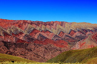
Jujuy is a province of Argentina, located in the extreme northwest of the country, at the borders with Chile and Bolivia. The only neighboring Argentine province is Salta to the east and south.
Cerro Galán is a caldera in the Catamarca Province of Argentina. It is one of the largest exposed calderas in the world and forms part of the Central Volcanic Zone of the Andes, one of the three volcanic belts found in South America. One of several major caldera systems in the Central Volcanic Zone, the mountain is grouped into the Altiplano–Puna volcanic complex.
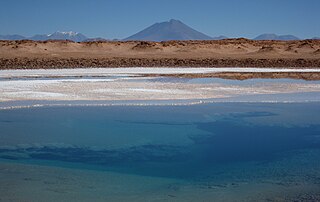
Salar de Atacama, located 55 km (34 mi) south of San Pedro de Atacama, is the largest salt flat in Chile. It is surrounded by mountains and lacks drainage outlets. To the east, it is enclosed by the main chain of the Andes, while to the west lies a secondary mountain range called Cordillera de Domeyko. The landscape is dominated by imposing volcanoes such as Licancabur, Acamarachi, Aguas Calientes, and Láscar, the latter being one of Chile's most active volcanoes. These volcanoes are situated along the eastern side of the Salar de Atacama, forming a north–south trending line that separates it from smaller endorheic basins.
Allkem Limited, known as Orocobre Limited until 30 November 2021, is an Australian mining company that is a wholly-owned subsidiary of Arcadium Lithium. Allkem's portfolio includes lithium brine operations in Argentina, a hard-rock lithium operation in Australia and a lithium hydroxide conversion facility in Japan. Allkem is dual listed on the Australian Securities Exchange and Toronto Stock Exchange. In May 2023, Allkem agreed terms to merge with Livent. In January 2024, Allkem and Livent merged to form the NYSE-listed Arcadium Lithium.
Salar de Pedernales is a large salt flat in the Atacama Region of Chile. It lies east of the Cordillera Domeyko at an elevation of 3,370 metres (11,060 ft). The salt flat has an irregular shape and consists mostly of gypsum and rock salt, with an area of 0.6 square kilometres (0.23 sq mi)-1.1 square kilometres (0.42 sq mi) covered by open water. During the late Pleistocene, the climate was wetter and thus open water covered a much larger area of Salar de Pedernales.
La Pacana is a Miocene age caldera in northern Chile's Antofagasta Region. Part of the Central Volcanic Zone of the Andes, it is part of the Altiplano-Puna volcanic complex, a major caldera and silicic ignimbrite volcanic field. This volcanic field is located in remote regions at the Zapaleri tripoint between Chile, Bolivia and Argentina.
Salar de Arizaro is a large salt flat of the Andes in north-western Argentina. It is located between the villages of Tolar Grande and Caipe and near Mina La Casualidad, in Los Andes Department, Salta Province.
Tuyajto Lake is a salt lake located in the Antofagasta Region, northern Chile. Located at an elevation of about 4,010 metres (13,160 ft), its surface area presently fluctuates between 1.7–2.7 square kilometres (0.66–1.04 sq mi) but in the past it was considerably larger; this led to humans going to the lake and creating archeological sites there. Presently, the lake is groundwater-fed and has no surface outlet but water might seep out underground. It is part of the Los Flamencos Natural Reserve.
Salta Basin or Salta Rift Basin is a sedimentary basin located in the Argentine Northwest. The basin started to accumulate sediments in the Early Cretaceous (Neocomian) and at present it has sedimentary deposits reaching thicknesses of 5,000 metres (16,000 ft). The basin contains seven sub-basins: Tres Cruces, Lomas de Olmedo, Metán, Alemanía, Salfity, El Rey, Sey and Brealito. The basin environment has variously been described as a "foreland rift" and an "intra-continental rift". The basin developed under conditions of extensional tectonics and rift-associated volcanism.
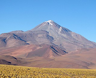
Llullaillaco is a dormant stratovolcano on the border between Argentina and Chile. It lies in the Puna de Atacama, a region of tall volcanic peaks on a high plateau close to the Atacama Desert, one of the driest places in the world. Its maximum elevation is most commonly given as 6723 m, making it the second- or third-highest volcano in the world. Despite its height, it is not clear whether the volcano has any glaciers or merely patches of perennial snow and ice. Between 3700 m and 5000 m elevation there is a sparse plant cover, while at lower altitudes the climate is too dry for plants to grow. A species of mouse on Llullaillaco is the highest-living known vertebrate species.
Pairique volcanic complex is a volcanic complex in the Jujuy Province, Argentina.
Pastos Grandes is the name of a caldera and its crater lake in Bolivia. The caldera is part of the Altiplano-Puna volcanic complex, a large ignimbrite province that is part of the Central Volcanic Zone of the Andes. Pastos Grandes has erupted a number of ignimbrites through its history, some of which exceeded a volume of 1,000 cubic kilometres (240 cu mi). After the ignimbrite phase, the lava domes of the Cerro Chascon-Runtu Jarita complex were erupted close to the caldera and along faults.
Antofalla is a Miocene-Pliocene volcano in Argentina's Catamarca Province. It is part of the volcanic segment of the Andes in Argentina, and it is considered to be part of the Central Volcanic Zone, one of the volcanic zones of the Andes. Antofalla forms a group of volcanoes that are aligned on and behind the main volcanic arc. Antofalla itself is a remote volcano.
Ojos de Mar is a group of 3–6 small water bodies close to the town of Tolar Grande in Argentina and an important tourist attraction there. They are inhabited by extremophile microorganisms of interest to biotechnology; stromatolites have also been found there.
Laguna Socompa is a small lake in the Salta Province of Argentina, at the foot of Socompa volcano. It covers an area of about 200 hectares and has an average depth of about 0.45–0.62 metres. The lake is fed by arroyos and springs, some of which are hot springs. Its waters are very rich in arsenic and otherwise salty and slightly alkaline; these properties and the regionally high UV radiation give Laguna Socompa extreme environmental conditions.
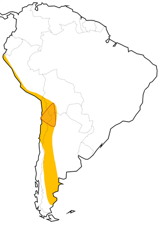
The Lithium Triangle is a region of the Andes that is rich in lithium reserves, encompassed by the borders of Argentina, Bolivia, and Chile. The lithium in the triangle is concentrated in various salt pans that exist along the Atacama Desert and neighboring arid areas. The largest areas three main salt pans that define its vertices are the Salar de Uyuni in Bolivia, Salar de Atacama in Chile, and Salar del Hombre Muerto in Argentina. Of these, the core of Salar de Atacama in Chile has the highest concentration of lithium among all world's brine sources.
The Geste Formation is a fossiliferous geologic formation of the Puna Plateau in the western Salta Province and northern Catamarca Province of the Argentine Northwest, northwestern Argentina.
Salar Ignorado is a salar in the Andes of Chile's Atacama Region at 4,250 metres (13,940 ft) elevation. Located just south of Cerro Bayo volcano, it comprises 0.7 square kilometres (0.27 sq mi) of salt flats, sand dunes and numerous pools of open water. The waters of Salar Ignorado, unlike these of other salt flats in the central Andes, are acidic owing to the input of sulfuric acid from hydrothermal water and the weathering of volcanic rocks.
Salar de Gorbea is a salt flat just south of the border between the Antofagasta and Atacama regions, within Chile but close to the border with Argentina.
Carachipampa is a Pleistocene volcanic cone in Argentina. Part of a wider, regional volcanic field, it has produced lava flows consisting of andesite. It is surrounded by a lake and a salt flat, the former of which features an ecosystem formed by microbes.