| Río de los Patos | |
|---|---|
 | |
| Location | |
| Country | Argentina |
The Río de los Patos is a river of Argentina.
| Río de los Patos | |
|---|---|
| | |
| Location | |
| Country | Argentina |
The Río de los Patos is a river of Argentina.
The Valle de los Patos Superior has a dry-summer subarctic climate (Koppen: Dsc). In July 1972, thermometers registered the temperature of -39C, the all-time record low of Argentina.
| Climate data for Valle de los Patos Superior, Elevation: 2880 m. (1967–1981) | |||||||||||||
|---|---|---|---|---|---|---|---|---|---|---|---|---|---|
| Month | Jan | Feb | Mar | Apr | May | Jun | Jul | Aug | Sep | Oct | Nov | Dec | Year |
| Record high °C (°F) | 27.0 (80.6) | 26.7 (80.1) | 26.6 (79.9) | 23.4 (74.1) | 21.0 (69.8) | 17.0 (62.6) | 16.8 (62.2) | 17.6 (63.7) | 18.4 (65.1) | 21.6 (70.9) | 24.6 (76.3) | 26.5 (79.7) | 27.0 (80.6) |
| Average high °C (°F) | 19.7 (67.5) | 19.4 (66.9) | 18.1 (64.6) | 14.9 (58.8) | 9.9 (49.8) | 4.6 (40.3) | 3.2 (37.8) | 5.1 (41.2) | 8.4 (47.1) | 11.6 (52.9) | 15.1 (59.2) | 18.2 (64.8) | 12.3 (54.1) |
| Daily mean °C (°F) | 10.9 (51.6) | 10.0 (50.0) | 8.0 (46.4) | 4.4 (39.9) | 1.5 (34.7) | −3.7 (25.3) | −5.5 (22.1) | −3.8 (25.2) | 0.1 (32.2) | 3.9 (39.0) | 6.8 (44.2) | 9.7 (49.5) | 3.5 (38.3) |
| Average low °C (°F) | 1.0 (33.8) | −0.1 (31.8) | −2.3 (27.9) | −6.0 (21.2) | −6.8 (19.8) | −11.7 (10.9) | −13.5 (7.7) | −12.5 (9.5) | −8.2 (17.2) | −4.3 (24.3) | −2.4 (27.7) | −0.1 (31.8) | −5.6 (21.9) |
| Record low °C (°F) | −6.4 (20.5) | −7.2 (19.0) | −10.7 (12.7) | −27.5 (−17.5) | −32.7 (−26.9) | −34.3 (−29.7) | −39.0 (−38.2) | −35.0 (−31.0) | −31.5 (−24.7) | −21.0 (−5.8) | −12.6 (9.3) | −8.9 (16.0) | −39.0 (−38.2) |
| Average precipitation mm (inches) | 6.4 (0.25) | 5.2 (0.20) | 3.8 (0.15) | 15.3 (0.60) | 29.9 (1.18) | 49.9 (1.96) | 40.5 (1.59) | 15.3 (0.60) | 13.7 (0.54) | 10.8 (0.43) | 10.8 (0.43) | 3.3 (0.13) | 205.0 (8.07) |
| Average snowy days | 0.6 | 0.1 | 0.2 | 2 | 6 | 8 | 9 | 5 | 4 | 3 | 2 | 0.7 | 40.6 |
| Average relative humidity (%) | 47 | 47 | 46 | 47 | 52 | 57 | 61 | 60 | 56 | 49 | 44 | 44 | 50.8 |
| Source: Servicio Meteorológico Nacional [1] [2] | |||||||||||||

Tucumán is the most densely populated, and the second-smallest by land area, of the provinces of Argentina.

Salta is a province of Argentina, located in the northwest of the country. Neighboring provinces are from the east clockwise Formosa, Chaco, Santiago del Estero, Tucumán and Catamarca. It also surrounds Jujuy. To the north it borders Bolivia and Paraguay and to the west lies Chile.

La Pampa is a sparsely populated province of Argentina, located in the Pampas in the center of the country. Neighboring provinces are from the north clockwise San Luis, Córdoba, Buenos Aires, Río Negro, Neuquén and Mendoza.

San Juan Province is a province of Argentina, located in the western part of the country. Neighbouring provinces are, moving clockwise from the north, La Rioja, San Luis and Mendoza. It borders with Chile to the west.

San Fernando del Valle de Catamarca is the capital and largest city in Catamarca Province in northwestern Argentina, on the Río Valle River, at the feet of the Cerro Ambato. The city name is normally shortened as Catamarca.
Neuquén is the capital city of the Argentine province of Neuquén and of the Confluencia Department, located in the east of the province. It occupies a strip of land west of the confluence of the Limay and Neuquén rivers which form the Río Negro, making it part of the ecoregion of Alto Valle del Río Negro. The city and surrounding area have a population of more than 340,000, making it the largest city in Patagonia. Along with the cities of Plottier and Cipolletti, it is part of the Neuquén – Plottier – Cipolletti conurbation.

Trevelin is a town in the western part of the Patagonian Argentine province of Chubut. The town lies on the eastern banks of the Percy River. It is located in the department of Futaleufú, 22 kilometres (14 mi) south of Esquel, and had 6,395 inhabitants at the time of the 2001 census [INDEC] and 7,908 inhabitants in the 2010 census [INDEC].

San Luis is the capital city of San Luis Province in the Cuyo region of Argentina. It is also the seat of the Juan Martín de Pueyrredón Department.

The Argentine Northwest is a geographic and historical region of Argentina composed of the provinces of Catamarca, Jujuy, La Rioja, Salta, Santiago del Estero and Tucumán.
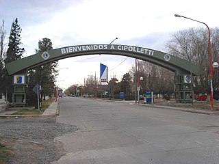
Cipolletti is a city in north of the Patagonian province of Río Negro, Argentina. With a population of 87,492 inhabitants at the 2010 census [INDEC], Cipolletti is the third-most populated settlement in the province, after San Carlos de Bariloche and General Roca.
Tinogasta is a city in the west of the province of Catamarca, Argentina, on the right-hand shore of the Abaucán River, about 280 km from the provincial capital San Fernando del Valle de Catamarca. It had about 11,500 inhabitants at the 2010 census [INDEC]. It is the head town of the department of the same name. The name of the city comes from the Kakana words tino ("meeting") and gasta ("town").

San Rafael is a city in the southern region of the Mendoza Province, Argentina. With more than 118,000 inhabitants, it is the largest city in and the seat of San Rafael Department.
Andalgalá is a city in the west-center of the province of Catamarca, Argentina, located in a valley near the Sierra de Aconquija, 260 km from the provincial capital San Fernando del Valle de Catamarca. It has about 14,000 inhabitants as per the 2001 census [INDEC]. It is the head town of the department of the same name. The Andalgalá River, which flows nearby, supports a hydroelectric power plant.
San José de Jáchal is a city in the northeast of the province of San Juan, Argentina, located on National Route 40, south of the Jáchal River. It has 21,018 inhabitants per the 2001 census [INDEC], and is the head town of the Jáchal Department.
The Paso de Los Patos(Passage of the Ducks) is an Andean mountain pass between Argentina and Chile, used by the main column of the Army of the Andes to cross the Andes in early 1817, in order to liberate Chile from Spain. It is located to the interior of the town of Putaendo, to the north of the city of San Felipe, Valparaíso Region, Chile, and framed by the imposing Valle de Los Patos Sur, SW of the Province of San Juan, Argentina. Other names are used for the same pass: the passages of Llaretas, Ortiz, the Honda and the Valle Hermoso.

Tafí del Valle is a city in Tucumán, Argentina. It is located in the department of the same name, of which it is the main settlement, in the west of the Argentine province of Tucumán, 126 km from the provincial capital, San Miguel de Tucumán.
The Río Blanco is a river of Argentina near Calingasta in the southwestern part of the province of San Juan. It is a tributary of the Río de los Patos which is one of the three sources of the San Juan River which empties into the Desaguadero River basin.

Puerto Santa Cruz is a town and municipality in Santa Cruz Province in southern Argentina. It lies near the Atlantic coast on the northern bank of the estuary of Santa Cruz River. It is the second oldest city in the province, being founded in 1878. It was the capital of the Santa Cruz National Territory until Río Gallegos took over the position in 1888. The town is a local centre for sheep and cattle farming. The presence of fresh water in an otherwise semi-arid environment allows for orchards and a local horticulture.
Valle El Manso is a valley in the Andes of Río Negro Province, Argentine Patagonia. Located in the vicinity of Chile it was settled in the late 19th century by Chileans of mestizo and Mapuche stock as well by European immigrants. Chiloé Archipelago in particular was the place of origin of most Chilean settlers. Early settlers engaged in subsistence farming. The valley was used to move cattle from the interior of Patagonia to the ports in the Pacific.
| | This article about a place in San Juan Province, Argentina is a stub. You can help Wikipedia by expanding it. |
| | This article related to a river in Argentina is a stub. You can help Wikipedia by expanding it. |