| Salar de Antofalla | |
|---|---|
 Salar de Antofalla | |
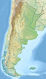
| Location | Argentina |
| Coordinates | 25°44′00″S67°45′00″W / 25.7333333°S 67.75°W |
| Basin countries | Argentina |
| Max. length | 136 km (85 mi) |
| Max. width | 10 km (6.2 mi) |
| Surface area | 500 km2 (193 sq mi) [1] |
| Surface elevation | 3,460 m (11,352 ft) |
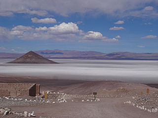
Salar de Antofalla is a salt flat in the Andes of Catamarca Province in the Argentine Northwest. The salt flat contains systems of oncoids that grow in the interface between proper salt flat and an adjacent wetlands. [1] The geology surrounding the southern part of Salar de Antofalla is made up of continental (e.i. non-marine) sedimentary rock that deposited from Late Eocene to Early Pleistocene times. [2]
Related Research Articles

Salar de Uyuni is the world's largest salt flat, or playa, at over 10,000 square kilometres (3,900 sq mi) in area. It is in the Daniel Campos Province in Potosí in southwest Bolivia, near the crest of the Andes at an elevation of 3,656 m (11,995 ft) above sea level.

Peinado is a stratovolcano in Catamarca Province, Argentina. It consists of a volcanic cone with a summit crater, surrounded at its foot by lava flows erupted from flank vents. It began erupting about 100,000 years ago, with the last eruption about 36,800 years ago. Future eruptions are possible.

Antofagasta de la Sierra is the northernmost department of Catamarca Province in Argentina.

Salar de Atacama, located 55 km (34 mi) south of San Pedro de Atacama, is the largest salt flat in Chile. It is surrounded by mountains and lacks drainage outlets. To the east, it is enclosed by the main chain of the Andes, while to the west lies a secondary mountain range called Cordillera de Domeyko. The landscape is dominated by imposing volcanoes such as Licancabur, Acamarachi, Aguas Calientes, and Láscar, the latter being one of Chile's most active volcanoes. These volcanoes are situated along the eastern side of the Salar de Atacama, forming a north–south trending line that separates it from smaller endorheic basins.

Oncolites are sedimentary structures composed of oncoids, which are layered structures formed by cyanobacterial growth. Oncolites are very similar to stromatolites, but, instead of forming columns, they form approximately spherical structures. The oncoids often form around a central nucleus, such as a shell fragment, and a calcium carbonate structure is deposited by encrusting microbes. Oncolites are indicators of warm waters in the photic zone, but are also known in contemporary freshwater environments. These structures rarely exceed 10 cm in diameter.

Salar de Talar is a 46 square kilometres salt flat located in the high puna of northern Chilean Andes, at an altitude of 3,950 m. It is part of a series of salt lakes and salt flats located at the foothills of a chain of volcanoes stretching along the eastern side of the much greater Salar de Atacama.
Allkem Limited, known as Orocobre Limited until 30 November 2021. Headquartered in Buenos Aires, Argentina, Allkem's portfolio includes lithium brine operations in Argentina, a hard-rock lithium operation in Australia and a lithium hydroxide conversion facility in Japan. Allkem is dual listed on the Australian Securities Exchange and Toronto Stock Exchange. In May 2023, Allkem agreed terms to merge with Livent.
Salar de Pedernales is a large salt flat in the Atacama Region of Chile. It lies east of the Cordillera Domeyko at an elevation of 3,370 metres (11,060 ft). The salt flat has an irregular shape and consists mostly of gypsum and rock salt, with an area of 0.6 square kilometres (0.23 sq mi)-1.1 square kilometres (0.42 sq mi) covered by open water. During the late Pleistocene, the climate was wetter and thus open water covered a much larger area of Salar de Pedernales.
Arequipa-Antofalla is a basement unit underlying the central Andes in northwestern Argentina, western Bolivia, northern Chile and southern Peru. Geologically, it corresponds to a craton, terrane or block of continental crust. Arequipa-Antofalla collided and amalgamated with the Amazonian craton about 1000 Ma ago during the Sunsás orogeny. As a terrane Arequipa-Antofalla was ribbon-shaped during the Paleozoic, a time when it was bounded by the west by the Iapetus Ocean and by the east by the Puncoviscana Ocean.
Salar de Arizaro is a large salt flat of the Andes in north-western Argentina. It is located between the villages of Tolar Grande and Caipe and near Mina La Casualidad, in Los Andes Department, Salta Province.

Cerro Beltrán is an andesitic-dacitic volcano in the Andes. It erupted andesitic-dacitic lava flows between 14.1 and 7.7 mya. Based on geochemical considerations, the volcano formed from granite and plagioclase bearing, 33–40 kilometres (21–25 mi) thick crust. Part of the volcano was later covered by ignimbrites coming from the Galán caldera eruption.
Cerro Archibarca is a volcano in the Andes. It covers a surface area of 20 square kilometres (7.7 sq mi). Lava flows descend from a conical edifice. It was active 11 million years ago. The youngest deposits are eroded andesites on the northern side.
Tebenquicho is a volcano in Argentina.

Antofalla is a Miocene-Pliocene volcano in Argentina's Catamarca Province. It is part of the volcanic segment of the Andes in Argentina, and it is considered to be part of the Central Volcanic Zone, one of the volcanic zones of the Andes. Antofalla forms a group of volcanoes that are aligned on and behind the main volcanic arc. Antofalla itself is a remote volcano.

Tata Sabaya is a 5,430-metre (17,810 ft) high volcano in Bolivia. It is part of the Central Volcanic Zone, one of several volcanic belts in the Andes which are separated by gaps without volcanic activity. This section of the Andes was volcanically active since the Jurassic, with an episode of strong ignimbritic volcanism occurring during the Miocene. Tata Sabaya lies in a thinly populated region north of the Salar de Coipasa salt pan.

Salar del Hombre Muerto is a salt pan in Argentina, in the Antofagasta de la Sierra Department on the border between the Salta and Catamarca Provinces. It covers an area of 600 square kilometres (230 sq mi) and is in part covered by debris. During the Pleistocene it was sometimes a lake, but today only parts of the salt pan are covered by perennial water bodies; its major tributary is the Rio de Los Patos.
The Geste Formation is a fossiliferous geologic formation of the Puna Plateau in the western Salta Province and northern Catamarca Province of the Argentine Northwest, northwestern Argentina.

Laguna Negra is a lake in the Catamarca Province of Argentina. It lies on the Puna high plateau next to two other lakes and salt flats. The lake is less than 2 metres deep and forms a rough rectangle with a surface of 8.6 square kilometres (3.3 sq mi). Laguna Negra loses its water through evaporation, and is replenished through surface runoff and groundwater which ultimately originate to a large part from snowmelt. The waters of the lake are salty.

Salar Ignorado is a salar in the Andes of Chile's Atacama Region at 4,250 metres (13,940 ft) elevation. Located just south of Cerro Bayo volcano, it comprises 0.7 square kilometres (0.27 sq mi) of salt flats, sand dunes and numerous pools of open water. The waters of Salar Ignorado, unlike these of other salt flats in the central Andes, are acidic owing to the input of sulfuric acid from hydrothermal water and the weathering of volcanic rocks.

Salar de Gorbea is a salt flat just south of the border between the Antofagasta and Atacama regions, within Chile but close to the border with Argentina.
References
- 1 2 Villafañe, Patricio Guillermo; Lencina, Agustina Inés; Soria, Mariana; Saona, Luis Alberto; Gómez, Fernado Javier; Alonso, Guido Ezequiel; Farías, María Eugenia (2021-05-01). "Las Quínoas oncoids: a new deposit of microbialites in the Salar de Antofalla (Catamarca, Argentina)". Andean Geology . 48 (2): 281–302. doi: 10.5027/andgeoV48n2-3292 . hdl: 11336/148257 .
- ↑ Voss, Reno (2002). "Cenozoic stratigraphy of the southern Salar de Antofalla region, northwestern Argentina". Revista Geológica de Chile (in Spanish). 29 (2): 167–189. doi: 10.4067/S0716-02082002000200002 .
| International | |
|---|---|
| Other | |
| | This article about a place in Catamarca Province, Argentina is a stub. You can help Wikipedia by expanding it. |