Puna de Atacama

Last updated
Puna de Atacama. The Argentinian part is in green and the Chilean in orange. Puna de Atacama dispute.svg
Puna de Atacama. The Argentinian part is in green and the Chilean in orange.
Salar de Atacama salt flat in the Chilean puna SalarDeatacamaFromChaxa.jpg
Salar de Atacama salt flat in the Chilean puna
Cono de Arita, Salta (Argentina) Cono de Arita, Salta. Argentina.jpg
Cono de Arita, Salta (Argentina)
Salar de Atacama with the volcanoes Pular (L), Cerro Pajonales (center left) and Socompa (R) in the distance. The 1899 border runs through Socompa. Salar de Atacama Pular.jpg
Salar de Atacama with the volcanoes Pular (L), Cerro Pajonales (center left) and Socompa (R) in the distance. The 1899 border runs through Socompa.

The Puna de Atacama or Atacama Plateau [1] is an arid high plateau, in the Andes of northern Chile (15%) and northwest of Argentina (85%). [2] Geomorphologist Walther Penck based his Grossfalt landform association on Puna de Atacama. [3]

Contents

Geography

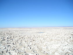
The plateau's elevation averages 4,500 m (14,800 ft) above sea level, and it spans an area of 180,000 km2 (69,000 sq mi).

In Argentina, Puna's territory is extended in the provinces of Salta, Jujuy, and western Catamarca. In Chile, it is included in the regions of Antofagasta and north-eastern Atacama. [2]

In December 2023, scientists, for the first time, reported a recently discovered area on the current planet Earth, particularly in the Puna's territory, which may be similar to ancient Earth, and the related environment of the first life forms on Earth - as well as - similar to possibly hospitable conditions on the planet Mars during earlier Martian times. [4]

International borders

Before the War of the Pacific (1879–1883), the region belonged to Bolivia. In 1898, it was ceded to Argentina in exchange for recognition of Tarija as part of Bolivia. Chile, which had annexed the Litoral Province from Bolivia, declared the exchange illegal. The border was defined in 1899 after the Puna de Atacama dispute. Of the 75,000 km2 in dispute, 64,000 (85%) were awarded to Argentina and 11,000 (15%) to Chile. [2]

See also

Related Research Articles

<span class="mw-page-title-main">Antofagasta Region</span> Region of Chile

The Antofagasta Region is one of Chile's sixteen first-order administrative divisions. The second-largest region of Chile in area, it comprises three provinces, Antofagasta, El Loa and Tocopilla. It is bordered to the north by Tarapacá, by Atacama to the south, and to the east by Bolivia and Argentina. The region's capital is the port city of Antofagasta; another one of its important cities is Calama. The region's main economic activity is copper mining in its giant inland porphyry copper systems.

<span class="mw-page-title-main">Jujuy Province</span> Province of Argentina

Jujuy is a province of Argentina, located in the extreme northwest of the country, at the borders with Chile and Bolivia. The only neighboring Argentine province is Salta to the east and south.

<span class="mw-page-title-main">Walther Penck</span> German geologist (1888–1923)

Walther Penck was a geologist and geomorphologist known for his theories on landscape evolution. Penck is noted for criticizing key elements of the Davisian cycle of erosion, concluding that the process of uplift and denudation occur simultaneously, at gradual and continuous rates. Penck's idea of parallel slope retreat led to revisions of Davis's cycle of erosion.

<span class="mw-page-title-main">Altiplano</span> Large plateau in west-central South America

The Altiplano, Collao or Andean Plateau, in west-central South America, is the most extensive high plateau on Earth outside Tibet. The plateau is located at the latitude of the widest part of the north–south-trending Andes. The bulk of the Altiplano lies in Bolivia, but its northern parts lie in Peru, and its southwestern fringes lie in Chile.

<span class="mw-page-title-main">San Pedro de Atacama</span> Town and Commune in Antofagasta, Chile

San Pedro de Atacama is a Chilean town and commune in El Loa Province, Antofagasta Region. It is located east of Antofagasta, some 106 km (60 mi) southeast of Calama and the Chuquicamata copper mine, overlooking the Licancabur volcano. It features a significant archeological museum, the R. P. Gustavo Le Paige Archaeological Museum, with a large collection of relics and artifacts from the region. Native ruins nearby attract increasing numbers of tourists interested in learning about pre-Columbian cultures.

<span class="mw-page-title-main">Purico complex</span> Pleistocene volcanic complex in Chile

The Purico complex is a Pleistocene volcanic complex in Chile close to Bolivia, formed by an ignimbrite, several lava domes and stratovolcanoes and one maar. It is in the Chilean segment of the Central Volcanic Zone, one of the four volcanic belts which make up the Andean Volcanic Belt. The Central Volcanic Zone spans Peru, Bolivia, Chile and Argentina and includes 44 active volcanoes as well as the Altiplano–Puna volcanic complex, a system of large calderas and ignimbrites of which Purico is a member. Licancabur to the north, La Pacana southeast and Guayaques to the east are separate volcanic systems.

<span class="mw-page-title-main">Salar de Atacama</span> Salt flat in Chile

Salar de Atacama, located 55 km (34 mi) south of San Pedro de Atacama, is the largest salt flat in Chile. It is surrounded by mountains and lacks drainage outlets. To the east, it is enclosed by the main chain of the Andes, while to the west lies a secondary mountain range called Cordillera de Domeyko. The landscape is dominated by imposing volcanoes such as Licancabur, Acamarachi, Aguas Calientes, and Láscar, the latter being one of Chile's most active volcanoes. These volcanoes are situated along the eastern side of the Salar de Atacama, forming a north–south trending line that separates it from smaller endorheic basins.

<span class="mw-page-title-main">Norte Grande</span> Northernmost natural region of Chile

The Norte Grande is one of the five natural regions into which CORFO divided continental Chile in 1950. It borders Peru to the north, the Pacific Ocean to the west, the Altiplano, Bolivia and Argentina to the east, and the Copiapó River to the south, beyond which lies the Norte Chico natural region.

<span class="mw-page-title-main">Atacama people</span> American indigenous people from the Atacama desert and altiplano region

The Atacama people, also called Atacameño, are an Indigenous people from the Atacama Desert and altiplano region in the north of Chile and Argentina and southern Bolivia, mainly the Antofagasta Region.

<span class="mw-page-title-main">Central Andean dry puna</span> Ecoregion in South America

The Central Andean dry puna (NT1001) is an ecoregion in the montane grasslands and shrublands biome, located in the Andean Altiplano in South America. It is a part of the Puna grassland.

<span class="mw-page-title-main">Atacama Desert</span> Desert in South America

The Atacama Desert is a desert plateau located on the Pacific coast of South America, in the north of Chile. Stretching over a 1,600 km (990 mi) strip of land west of the Andes Mountains, it covers an area of 105,000 km2 (41,000 sq mi), which increases to 128,000 km2 (49,000 sq mi) if the barren lower slopes of the Andes are included.

<span class="mw-page-title-main">Puna de Atacama dispute</span> Territorial dispute between Chile and Argentina

The Puna de Atacama dispute, sometimes referred to as Puna de Atacama Lawsuit, was a border dispute involving Argentina, Chile and Bolivia in the 19th century over the arid high plateau of Puna de Atacama located about 4500 meters above the sea around the current borders of the three countries.

The Atacama Desert is the most arid desert in the world which is located in Chile.

<span class="mw-page-title-main">Tolar Grande</span> Municipality and village in Salta, Argentina

Tolar Grande is a village and rural municipality in Salta Province in northwestern Argentina.

<span class="mw-page-title-main">Andean orogeny</span> Ongoing mountain-forming process in South America

The Andean orogeny is an ongoing process of orogeny that began in the Early Jurassic and is responsible for the rise of the Andes mountains. The orogeny is driven by a reactivation of a long-lived subduction system along the western margin of South America. On a continental scale the Cretaceous and Oligocene were periods of re-arrangements in the orogeny. The details of the orogeny vary depending on the segment and the geological period considered.

<span class="mw-page-title-main">Salta–Antofagasta railway</span> Railway line in Argentina and Chile

The Salta–Antofagasta railway, also named Huaytiquina, is a non-electrified single track railway line that links Argentina and Chile passing through the Andes. It is a 1,000 mmmetre gauge railway with a total length of 941 km, connecting the city of Salta (Argentina) to the one of Antofagasta (Chile), on the Pacific Ocean, passing through the Puna de Atacama and Atacama Desert.

<span class="mw-page-title-main">Salar de Arizaro</span> Salt flat in north-western Argentina

Salar de Arizaro is a large salt flat of the Andes in north-western Argentina. It is located between the villages of Tolar Grande and Caipe and near Mina La Casualidad, in Los Andes Department, Salta Province.

<span class="mw-page-title-main">Tuyajto Lake</span> Lake in Antofagasta Region, Chile

Tuyajto Lake is a salt lake located in the Antofagasta Region, northern Chile. Located at an elevation of about 4,010 metres (13,160 ft), its surface area presently fluctuates between 1.7–2.7 square kilometres (0.66–1.04 sq mi) but in the past it was considerably larger; this led to humans going to the lake and creating archeological sites there. Presently, the lake is groundwater-fed and has no surface outlet but water might seep out underground. It is part of the Los Flamencos Natural Reserve.

<span class="mw-page-title-main">Lake Tauca</span> Former lake, Pleisto- Holocene glacial lake, 72,600–7200 BP in Andes, South America

Lake Tauca is a former lake in the Altiplano of Bolivia. It is also known as Lake Pocoyu for its constituent lakes: Lake Poopó, Salar de Coipasa and Salar de Uyuni. The lake covered large parts of the southern Altiplano between the Eastern Cordillera and the Western Cordillera, covering an estimated 48,000 to 80,000 square kilometres of the basins of present-day Lake Poopó and the Salars of Uyuni, Coipasa and adjacent basins. Water levels varied, possibly reaching 3,800 metres (12,500 ft) in altitude. The lake was saline. The lake received water from Lake Titicaca, but whether this contributed most of Tauca's water or only a small amount is controversial; the quantity was sufficient to influence the local climate and depress the underlying terrain with its weight. Diatoms, plants and animals developed in the lake, sometimes forming reef knolls.

<span class="mw-page-title-main">Llullaillaco</span> Dormant stratovolcano at the border of Argentina and Chile

Llullaillaco is a dormant stratovolcano at the border of Argentina and Chile. It lies in the Puna de Atacama, a region of tall volcanic peaks on a high plateau close to the Atacama Desert, one of the driest places in the world. It is the second highest active volcano in the world after Ojos del Salado.

References

  1. Atacama Plateau article at the Encyclopædia Britannica website
  2. 1 2 3 (in Spanish) Historia de la relacciones exteriores de la Argentina Archived 2009-12-17 at the Wayback Machine
  3. Simons, Martin (1962), "The morphological analysis of landforms: A new review of the work of Walther Penck (1888-1923)", Transactions and Papers (Institute of British Geographers), 31 (31): 1–14, doi:10.2307/621083, JSTOR   621083
  4. Strain, Daniel (6 December 2023). "Deep within an inhospitable desert, a window to first life on Earth". University of Colorado . Archived from the original on 30 December 2023. Retrieved 30 December 2023.

23°27′36″S67°21′36″W / 23.46000°S 67.36000°W / -23.46000; -67.36000