Mandara Plateau mosaic

Last updated
Mandara Plateau mosaic
Mandara Mountains - panoramio.jpg
Mandara Mountains, Cameroon
AT0710 map.png
map of the Mandara Plateau mosaic
Ecology
Realm Afrotropical
Biome tropical and subtropical grasslands, savannas, and shrublands
Borders
Geography
Area7,526 km2 (2,906 sq mi)
Countries
Conservation
Conservation status Critical/endangered [1]
Protected16 km² (0%) [2]

The Mandara Plateau mosaic, also known as the Mandara Plateau woodlands, is a tropical grasslands, savannas, and shrublands ecoregion located in the Mandara Mountains of northern Nigeria and Cameroon.

Contents

Geography

This ecoregion covers the Mandara Mountains, which straddle the border between northern Nigeria and northern Cameroon. The highest peak is Mont Oupay in Cameroon, which reaches 1,494 meters elevation. Most of the ecoregion lies between 1000 and 1200 meters elevation. The ecoregion includes high plains, plateau areas above 1200 meters elevation, and higher mountains.

The mountains are composed of ancient granite. Soils are generally nutrient-poor and infertile. [1]

The valley of the Benue River lies to the south, and its tributaries drain the southern portion of the mountains. The northern portion drains north into the basin of Lake Chad.

Climate

The ecoregion has tropical savanna climate, moderated by elevation. Average annual rainfall varies from 800 to 1000 mm depending on location. Most rain falls during the long wet season from May to October, and the rest of the year is dry. [1]

Flora

Open woodlands, dominated by the tree Isoberlinia doka , were once the dominant plant community in the ecoregion, but generally fragmented and degraded areas of woodland remain. In relatively intact woodlands the trees reach 12 to 18 meters high, and tree cover averages 50% or more. Grasses, including species of Andropogon and Beckeropsis , are predominant in the ground layer and understory. [1]

The highest-elevation areas, from 1,200 to 1,494 meters elevation, are home to a mix of lowland (Sudanian) and montane and submontane (Afromontane) species, including some rare and endemic ones. High-elevation species include the large tree-like succulent Euphorbia desmondi and the trees Olea hochstetteri and Pittosporum viridiflorum . [1]

Fauna

Animals native to the mountains include the engangered western mountain reedbuck (Redunca fulvorufula adamauae) and breeding populations of Rüppell's griffin vulture (Gyps rueppelli) and Egyptian vulture (Neophron percnopterus). [1]

The mountains have three endemic reptiles, the Mount Lefo chameleon (Trioceros wiedersheimi), Mabuya langheldi , and the African wall gecko ( Tarentola ephippiata ). [1]

People

The Mandara Mountains sustain a relatively dense population, despite the topography and relatively poor soils. Historically the mountains were a refuge for people resisting conquest or enslavement by states on the surrounding plains, and the mountains sustain a great diversity of languages and traditional religions. Local people developed a system of intensive agriculture involving the construction of terraces and measures to retain and improve soil fertility. Domestic sheep, goats, and cattle are kept and fed in pens during the crop-growing season, and their manure is deposited on the terraces after each harvest. Domestic animals are allowed to graze on the terraces' plant stubble after harvest to ensure that the manure fertilizes the fields. Household, human, and plant waste is used to improve the soil on terraces. Crop rotation between sorghum, millet, and legumes maintains soil fertility and reduces pests. Trees are used for shade, fodder, and green manure. Khaya senegalensis and Acacia albida are the most important, along with about 30 other species. [3]

Threats and preservation

Problems facing the region stem from the intense agriculture and include heavy grazing, collection of firewood, and burning, which have cleared nearly all of the region. [4]

Protected areas

Mozogo-Gokoro National Park and Mayo-Louti Forest Reserve in Cameroon cover lower-elevation portions of the mountains. The high peaks, which are of the greatest biological interest, are unprotected. [1]

Mozogo-Goroko National Park has an area of 14.0 km2. [4] It was designated a forest reserve by the French Colonial Government in 1932, and designated a national park by the Republic of Cameroon in 1968. Burning and grazing have been curtailed within the park for decades, and it is covered in a mosaic of dense to open dry forests, gallery forests along seasonal watercourses, and thickets. Predominant trees include Senegalia ataxacantha, Anogeissus leiocarpa, Tamarindus indica, Psorospermum senegalense, Clerodendrum capitatum , and Celtis toka . The park sustains a relatively high species diversity despite its small size, with 110 woody plant species from 46 genera and 30 families, and 114 species of mammals, birds, reptiles, and amphibians. The flora is mostly semi-arid Sahelian species, but also includes Sudanian and Guinean species characteristic of more humid-climate regions. [5]

Mayo-Louti Forest Reserve (60km2) lies on high plains east of the main chain of mountains. The Mayo-Louti River forms the western border of the reserve, and Mayo-Wanday River forms the eastern. The reserve is mostly dry savanna woodland with species of Isoberlinia, Piliostigma, Crossopteryx , and Cussonia trees, and Khaya senegalensis growing along the three northward-flowing rivers that bound or cross the reserve. [6]

Some of the region's communities preserve areas of forest as sacred groves, protected by traditional rules such as totems, taboos, and myths which discourage human exploitation. A survey of the sacred grove near the village of Mouhour, one km south of Mokolo, found the grove had relatively high plant species diversity, carbon stock, and tree cover. [7]

Related Research Articles

<span class="mw-page-title-main">Ecology of California</span> Environments and natural history of California

The ecology of California can be understood by dividing the state into a number of ecoregions, which contain distinct ecological communities of plants and animals in a contiguous region. The ecoregions of California can be grouped into four major groups: desert ecoregions, Mediterranean ecoregions, forested mountains, and coastal forests.

<span class="mw-page-title-main">Eastern Highlands</span> Mountain range in Zimbabwe and Mozambique

The Eastern Highlands, also known as the Manica Highlands, is a mountain range on the border of Zimbabwe and Mozambique. The Eastern Highlands extend north and south for about 300 kilometres (190 mi) through Zimbabwe's Manicaland Province and Mozambique's Manica Province.

<span class="mw-page-title-main">North Region (Cameroon)</span> Region of Cameroon

The North Region makes up 66,090 km2 of the northern half of The Republic of Cameroon. Neighbouring territories include the Far North Region to the north, the Adamawa Region to the south, Nigeria to the west, Chad to the east, and Central African Republic to the southeast. The city of Garoua is both the political and industrial capital. Garoua is Cameroon's third largest port, despite the fact that the Bénoué River upon which it relies is only navigable for short periods of the year.

<span class="mw-page-title-main">Mandara Mountains</span> Mountain range in Nigeria and Cameroon

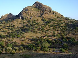
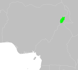
The Mandara Mountains are a volcanic range extending about 190 km along the northern part of the Cameroon–Nigeria border, from the Benue River in the south to the north-west of Maroua in the north. The highest elevation is the summit of Mount Oupay, at 1,494 m (4,900 ft) above sea level.

<span class="mw-page-title-main">Forest–savanna mosaic</span> Forest in dry regions

Forest–savanna mosaic is a transitory ecotone between the tropical moist broadleaf forests of Equatorial Africa and the drier savannas and open woodlands to the north and south of the forest belt. The forest–savanna mosaic consists of drier forests, often gallery forest, interspersed with savannas and open grasslands.

<span class="mw-page-title-main">Sudanian savanna</span> African region south of the Sahel

The Sudanian savanna or Sudan region is a broad belt of tropical savanna that runs east and west across the African continent, from the Ethiopian Highlands in the east to the Atlantic Ocean in the west. It represents the central bioregion within the broader tropical savanna biome of the Afrotropical realm. The Sahel acacia savanna, a belt of drier grasslands, lies to the north, forming a transition zone between the Sudanian savanna and the Sahara Desert phytochorion. To the Sudan's south, the more humid forest-savanna mosaic forms a transition zone between the Sudanian savanna and the Guineo-Congolian forests that lie nearer the equator.

<span class="mw-page-title-main">East Sudanian savanna</span> Tropical savanna ecoregion in Africa

The East Sudanian savanna is a hot, seasonally dry tropical savanna ecoregion of Central and East Africa.

<span class="mw-page-title-main">Northern Congolian forest–savanna mosaic</span> Forest and savanna ecoregion of Central Africa

The Northern Congolian forest–savanna mosaic is a forest and savanna ecoregion of central Africa. It extends east and west across central Africa, covering parts of Cameroon, Central African Republic, Democratic Republic of the Congo, South Sudan, and Uganda. It is part of the belt of transitional forest-savanna mosaic that lie between Africa's moist equatorial Guineo-Congolian forests and the tropical dry forests, savannas, and grasslands to the north and south.

<span class="mw-page-title-main">Cameroonian Highlands forests</span> Forest ecoregion in Cameroon and Nigeria

The Cameroonian Highlands forests, also known as the Cameroon Highlands forests, is a montane tropical moist broadleaf forest ecoregion located on the range of mountains that runs inland from the Gulf of Guinea and forms the border between Cameroon and Nigeria. This is an area of forest and grassland which has become more populous as land is cleared for agriculture.

<span class="mw-page-title-main">Wildlife of Cameroon</span>

The wildlife of Cameroon is composed of its flora and fauna. Bordering Nigeria, it is considered one of the wettest parts of Africa and records Africa's second highest concentration of biodiversity. To preserve its wildlife, Cameroon has more than 20 protected reserves comprising national parks, zoos, forest reserves and sanctuaries. The protected areas were first created in the northern region under the colonial administration in 1932; the first two reserves established were Mozogo Gokoro Reserve and the Bénoué Reserve, which was followed by the Waza Reserve on 24 March 1934. The coverage of reserves was initially about 4 percent of the country's area, rising to 12 percent; the administration proposes to cover 30 percent of the land area.

<span class="mw-page-title-main">South Malawi montane forest–grassland mosaic</span>

The South Malawi montane forest–grassland mosaic is an ecoregion of Malawi.

<span class="mw-page-title-main">Southern Zanzibar–Inhambane coastal forest mosaic</span> Tropical moist broadleaf forest ecoregion of eastern Africa

The Southern Zanzibar–Inhambane coastal forest mosaic, also known as the Southern Swahili coastal forests and woodlands, is a tropical moist broadleaf forest ecoregion of eastern Africa. It is a southern variation of Northern Zanzibar-Inhambane coastal forest mosaic. The ecoregion supports habitats of forest, savanna and swamps. The southern portion of the ecoregion is not as well studied due to the 1977-1992 civil war in Mozambique.

<span class="mw-page-title-main">Angolan Scarp savanna and woodlands</span>

The Angolan Scarp savanna and woodlands is an ecoregion located on the coast of Angola, an area with a variety of habitats and rich in wildlife including many endemic birds and animals.

<span class="mw-page-title-main">Northern Zanzibar–Inhambane coastal forest mosaic</span> Tropical forest ecoregion of East Africa

Northern Zanzibar–Inhambane coastal forest mosaic, also known as the Northern Swahili coastal forests and woodlands, is a tropical moist broadleaf forest ecoregion of coastal East Africa. The ecoregion includes a variety of habitats, including forest, savanna and swamps.

<span class="mw-page-title-main">West Sudanian savanna</span> Tropical savanna ecoregion across Western Africa

The West Sudanian savanna is a tropical savanna ecoregion that extends across West Africa.

<span class="mw-page-title-main">Nimba Range</span> Southern extent of the Guinea highlands

The Nimba Range forms part of the southern extent of the Guinea Highlands, adjacent to the Toura Mountains. The highest peak is Mount Nimba on the border of Liberia, Ivory Coast and Guinea, at 1,752 m (5,748 ft), and at the intersection of the Nimba and Toura Mountains. "Mount Nimba" may refer either to Mount Richard-Molard or to the entire range. Other peaks include Grand Rochers at 1,694 m (5,558 ft), Mont Sempéré at 1,682 m (5,518 ft), Mont Piérré Richaud at 1,670 m (5,480 ft), Mont Tô at 1,675 m (5,495 ft), and Mont LeClerc 1,577 m (5,174 ft), all of them are located in Guinea. Mount Nimba Strict Nature Reserve of Guinea and Ivory Coast covers significant portions of the Nimba Range.

<span class="mw-page-title-main">Southwestern Arabian foothills savanna</span> Desert and xeric shrubland ecoregion of the southern Arabian Peninsula

The Southwestern Arabian foothills savanna, also known as the Southwestern Arabian Escarpment shrublands and woodlands, is a desert and xeric shrubland ecoregion of the southern Arabian Peninsula, covering portions of Saudi Arabia, Yemen, and Oman.

<span class="mw-page-title-main">Victoria Basin forest–savanna mosaic</span>

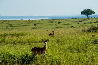
The Victoria Basin forest–grassland mosaic is an ecoregion that lies mostly in Uganda and extends into neighboring countries. The ecoregion is centered north and west of Lake Victoria, with an outlier on the border of Ethiopia and South Sudan.

References

  1. 1 2 3 4 5 6 7 8 "Mandara Plateau mosaic". Terrestrial Ecoregions. World Wildlife Fund.
  2. Eric Dinerstein, David Olson, et al. (2017). An Ecoregion-Based Approach to Protecting Half the Terrestrial Realm, BioScience, Volume 67, Issue 6, June 2017, Pages 534–545; Supplemental material 2 table S1b.
  3. Riddell, James C., and David J. Campbell. “Agricultural Intensification and Rural Development: The Mandara Mountains of North Cameroon.” African Studies Review, vol. 29, no. 3, 1986, pp. 89–106. JSTOR, www.jstor.org/stable/524085. Accessed 7 Aug. 2021.
  4. 1 2 "Mozogo Goroko". Protected Planet. Accessed 6 August 2021.
  5. Sandjong Sani, R.C., Ntoupka, M., Toua, V. et al. Phytoecological valorization attributes of Mozogo-Gokoro National Park (Cameroon). Environ Monit Assess 191, 79 (2019). https://doi.org/10.1007/s10661-019-7186-9
  6. BirdLife International (2021) Important Bird Areas factsheet: Mayo-Louti Forest Reserve. Accessed 6 August 2021.
  7. Kemeuze, V.A., Mapongmetsem, P.M., Sonwa, D.J., Fongnzossie, E. and Nkongmeneck, B.A. 2015. Plant diversity and carbon stock in sacred groves of semi-arid areas of Cameroon: case study of Mandara mountains. International Journal of Environment. 4(2), pp.308-318.