A biome is a distinct geographical region with specific climate, vegetation, and animal life. It consists of a biological community that has formed in response to its physical environment and regional climate. Biomes may span more than one continent. A biome encompasses multiple ecosystems within its boundaries. It can also comprise a variety of habitats.

The Serengeti National Park is a large national park in northern Tanzania that stretches over 14,763 km2 (5,700 sq mi). It is located in eastern Mara Region and northeastern Simiyu Region and contains over 1,500,000 hectares of virgin savanna. The park was established in 1940.

A savanna or savannah is a mixed woodland-grassland ecosystem characterised by the trees being sufficiently widely spaced so that the canopy does not close. The open canopy allows sufficient light to reach the ground to support an unbroken herbaceous layer consisting primarily of grasses. According to Britannica, there exists four savanna forms; savanna woodland where trees and shrubs form a light canopy, tree savanna with scattered trees and shrubs, shrub savanna with distributed shrubs, and grass savanna where trees and shrubs are mostly nonexistent.

Ngorongoro Conservation Area is a protected area and a UNESCO World Heritage Site located in Ngorongoro District, 180 km (110 mi) west of Arusha City in Arusha Region, within the Crater Highlands geological area of northern Tanzania. The area is named after Ngorongoro Crater, a large volcanic caldera within the area. The Ngorongoro Conservation Area Authority administers the conservation area, an arm of the Tanzanian government, and its boundaries follow the boundary of the Ngorongoro District in Arusha Region. The western portion of the park abuts the Serengeti National Park, and the area comprising the two parks and Kenya's Maasai Mara game reserve is home to Great Migration, a massive annual migration of millions of wildebeest, zebras, gazelles, and other animals. The conservation area also contains Olduvai Gorge, one of the most important paleoanthropological sites in the world.

The Coastal forests of eastern Africa, also known as the East African Coastal Forests or Zanzibar–Inhambane forests, is a tropical moist forest region along the east coast of Africa. The region was designated a biodiversity hotspot by Conservation International.

The South Saharan steppe and woodlands, also known as the South Sahara desert, is a deserts and xeric shrublands ecoregion of northern Africa. This band is a transitional region between the Sahara's very arid center to the north, and the wetter Sahelian Acacia savanna ecoregion to the south. In pre-modern times, the grasslands were grazed by migratory gazelles and other ungulates after the rainfalls. More recently, over-grazing by domestic livestock have degraded the territory. Despite the name of the ecoregion, there are few 'woodlands' in the area; those that exist are generally acacia and shrubs along rivers and in wadis.

The Willamette Valley ecoregion is a Level III ecoregion designated by the United States Environmental Protection Agency in the U.S. states of Oregon and Washington. Slightly larger than the Willamette Valley for which it is named, the ecoregion contains fluvial terraces and floodplains of the Willamette River system, scattered hills, buttes, and adjacent foothills. It is distinguished from the neighboring Coast Range, Cascades, and Klamath Mountains ecoregions by lower precipitation, lower elevation, less relief, and a different mosaic of vegetation. Mean annual rainfall is 37 to 60 inches, and summers are generally dry. Historically, the region was covered by rolling prairies, oak savanna, coniferous forests, extensive wetlands, and deciduous riparian forests. Today, it contains the bulk of Oregon's population, industry, commerce, and agriculture. Productive soils and a temperate climate make it one of the most important agricultural areas in Oregon.

The Eastern Cascades Slopes and Foothills ecoregion is a Level III ecoregion designated by the United States Environmental Protection Agency (EPA) in the U.S. states of Oregon, Washington, and California. In the rain shadow of the Cascade Range, the eastern side of the mountains experiences greater temperature extremes and receives less precipitation than the west side. Open forests of ponderosa pine and some lodgepole pine distinguish this region from the Cascades ecoregion, where hemlock and fir forests are more common, and from the lower, drier ecoregions to the east, where shrubs and grasslands are predominant. The vegetation is adapted to the prevailing dry, continental climate and frequent wildfire. Volcanic cones and buttes are common in much of the region.

The East African montane forests is a montane tropical moist forest ecoregion of eastern Africa. The ecoregion comprises several separate areas above 2000 meters in the mountains of South Sudan, Uganda, Kenya, and Tanzania.

Northern Zanzibar–Inhambane coastal forest mosaic, also known as the Northern Swahili coastal forests and woodlands, is a tropical moist broadleaf forest ecoregion of coastal East Africa. The ecoregion includes a variety of habitats, including forest, savanna and swamps.

The Idaho Batholith ecoregion is a Level III ecoregion designated by the United States Environmental Protection Agency (EPA) in the U.S. states of Idaho and Montana. It is contained within the following biomes designated by the World Wild Fund for Nature (WWF): temperate coniferous forests; temperate grasslands, savannas, and shrublands; and deserts and xeric shrublands.

The Ethiopian montane forests is a tropical moist broadleaf forest ecoregion in eastern Africa. It covers the middle elevations of the Ethiopian Highlands in Ethiopia and extends into neighboring Eritrea, Sudan, Djibouti, and Somaliland. The ecoregion includes distinctive Afromontane forests, woodlands, grasslands, and shrublands. The ecoregion's biodiversity is threatened by deforestation, conversion to agriculture, and overgrazing.

The Khopyor Nature Reserve is a Russian zapovednik that protects a 50-km-long stretch of the Khopyor River in the Voronezh Oblast. About 80% of the area is covered by forests, floodplain, and upland oak woods, with small areas of steppe and meadowlands. There are about 400 lakes and oxbows. The reserve is situated in the Novokhopyorsky District of Voronezh Oblast.

The Monte Alegre várzea (NT0141) is an ecoregion of seasonally flooded várzea forest along the Amazon River in the Amazon biome.

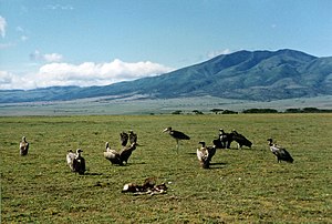
The Southern Acacia–Commiphora bushlands and thickets is a tropical grasslands, savannas, and shrublands ecoregion in Tanzania and Kenya. It includes portions of Serengeti National Park and Ngorongoro Conservation Area, which are designated World Heritage Sites and biosphere reserves for their outstanding wildlife and landscapes. It is one of three Acacia–Commiphora bushlands and thickets ecoregions in eastern Africa.

The Victoria Basin forest–grassland mosaic is an ecoregion that lies mostly in Uganda and extends into neighboring countries. The ecoregion is centered north and west of Lake Victoria, with an outlier on the border of Ethiopia and South Sudan.

The North Tibetan Plateau-Kunlun Mountains alpine desert ecoregion covers a long stretch of mostly treeless alpine terrain across the northern edge of the Tibet Plateau. A variety of cold, dry habitats are found, including alpine meadows, steppe, desert, and cushion plant floral areas.
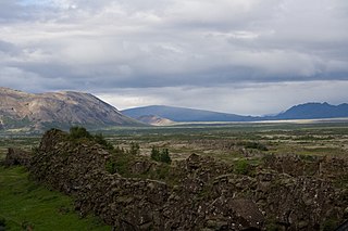
The Iceland boreal birch forests and alpine tundra ecoregion covers the island of Iceland in the North Atlantic. The island is volcanic in origin with basaltic soils, and the cold northerly climate prevents any significant crop agriculture. Because the island is young and isolated from larger land masses, species biodiversity is relatively low. Forest cover has been reduced to about 1% of the original birch forest by a long history of timber extraction and soil erosion caused by sheep grazing. Blanket bogs are common.

The Red Sea Nubo–Sindian tropical desert and semi-desert ecoregion covers extremely arid land along the northeastern Red Sea, the southern Sinai Peninsula, and on a thin strip along the Israel-Jordan border. Most of the coastal land is flat, but there are high mountains in southern Sinai. Biodiversity is limited by the low moisture levels – some areas go for years without significant rain. Portions of the area support a thin savannah-like cover of widely scattered trees and scrub, surrounded by grasses that briefly flourish after a rainfall. Biodiversity is highest in the mountains of Sinai, and in the wadis and gullies that retain moisture.

The Sulaiman Range alpine meadows ecoregion covers a series of higher altitude mountain ranges along the crest of the Sulaiman Mountains, a southerly extension of the Hindu Kush Mountains along the Afghanistan-Pakistan border. The area is relatively undeveloped, with about a third of the terrain either forested or in 'alpine steppe' shrub or herbaceous cover.