Mount Hanang

Last updated
Mount Hanang
Mount Hanang.jpg
Mount Hanang
Highest point
Elevation 3,420 m (11,220 ft) [1]
Prominence 2,050 m (6,730 ft) [1]
Listing Ultra
Coordinates 4°26′06″S35°24′00″E / 4.43500°S 35.40000°E / -4.43500; 35.40000 [1]
Geography
Tanzania relief location map.svg
Red triangle with thick white border.svg
Mount Hanang
Tanzania
Location Manyara Region,
Tanzania
Geology
Mountain type Stratovolcano [2]
Last eruption Pleistocene [2]

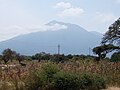
Mount Hanang is a mountain in northern Tanzania. The peak has an elevation of 3,420 m [1] above sea level. Hanang is located in Manyara Region's Hanang District. It is (after Mount Kilimanjaro, Mount Meru and Mount Loolmalasin) the fourth-highest mountain in Tanzania, if the three peaks of Kilimanjaro are counted as one mountain. [3]

Contents

The principal path to the summit starts in the town of Katesh. The climb can be done in one day (10 hours), but it is also common for climbers to spend one night in a tented camp on the mountain and reach the summit on the second day. [3]

Hanang Forest Reserve

Mount Hanang Nature Forest Reserve has an area of 58.66 km², [4] protecting an enclave of evergreen montane forest on the mountain's higher slopes. Between 2000 and 2700 meters elevation, evergreen montane forests cover the mountain's wetter eastern and southern slopes, while the drier western and northern slopes are home to dry montane evergreen forests with bushland and grassland on the ridges. Above 2700 meters, the forests transition to ericaceous heathland and high-altitude grasslands. [5]

Geology

Mount Hanang is a dormant stratovolcano. [2] Its most recent eruption was in the Pleistocene. [2]

See also

Related Research Articles

<span class="mw-page-title-main">Mount Cameroon</span> Active volcano in Cameroon near the Gulf of Guinea

Mount Cameroon is an active volcano in the South West region of Cameroon next to the city of Buea near the Gulf of Guinea. Mount Cameroon is also known as Cameroon Mountain or Fako or by its indigenous name Mongo ma Ndemi. Mount Cameroon is ranked 22nd by topographic isolation.

<span class="mw-page-title-main">Mount Meru (Tanzania)</span> Dormant stratovolcano in Arusha Region, Tanzania

Mount Meru is a dormant stratovolcano located 70 kilometres (43 mi) west of Kilimanjaro in southeast Arusha Region, Tanzania. At a height of 4,562.13 metres (14,968 ft), it is visible from Mount Kilimanjaro on a clear day, and is the fifth-highest of the highest mountain peaks of Africa, dependent on definition.

<span class="mw-page-title-main">Kilimanjaro National Park</span> National park in Kilimanjaro Region of Tanzania

Kilimanjaro National Park is a Tanzanian national park located 300 kilometres (190 mi) south of the equator in the Kilimanjaro Region, Tanzania. The park is located near the region of Moshi. The park includes the whole of Mount Kilimanjaro above the tree line and the surrounding montane forest belt above 1,820 metres (5,970 ft). It covers an area of 1,688 square kilometres (652 sq mi), 2°50'–3°10'S 37°10'–37°40'E. The park is administered by the Tanzania National Parks Authority (TANAPA). It was established as a national park in 1973.

The Nguru Mountains are a mountain range in Morogoro Region, Tanzania, Africa. They are part of the Eastern Arc Mountains. The mountains are predominantly covered with rainforest, home to 83 species of birds and African violets. Several forest reserves are located in the mountains.

The Viphya Mountains, also known as the Viphya Plateau or Viphya Highlands, are a mountain range in Malawi's Northern Region.

The Kipengere Range, also known as the Livingstone Mountains, lies entirely in Njombe Region in southwest Tanzania at the northern end of Lake Nyasa. Near Lake Nyasa they are known as the Kinga Mountains. It is a plateau-like ridge of mountains running southeastwards from the basin of the Great Ruaha River in the north to that of the Ruhuhu River in the south, and forms part of the eastern escarpment of the East African Rift. The range is mostly clad in montane grasslands, renowned for their botanical diversity and displays of flowers, with montane evergreen forests mostly in stream valleys.

<span class="mw-page-title-main">Udzungwa Mountains</span> Mountain range in south-central Tanzania

The Udzungwa Mountains are a mountain range in south-central Tanzania. The mountains are mostly within Iringa Region, south of Tanzania's capital Dodoma. The Udzungwa Mountains are part of the Eastern Arc Mountains, and are home to a biodiverse community of flora and fauna with large numbers of endemic species.

<span class="mw-page-title-main">Mount Rungwe</span> Volcano in Mbeya Region of Tanzania

Mount Rungwe is a volcanic mountain in Mbeya Region, in Tanzania's Southern Highlands. At an altitude of 2,981 metres (9,780 ft), it is southern Tanzania's second-highest peak. Rungwe's volcano is currently inactive.

<span class="mw-page-title-main">Mount Cameroon and Bioko montane forests</span>

The Mount Cameroon and Bioko montane forests is a tropical moist broadleaf forest ecoregion in central Africa. It occupies the upper slopes of coastal Mount Cameroon in Cameroon, and the mountains of nearby Bioko island in Equatorial Guinea.

<span class="mw-page-title-main">Comoros forests</span> Ecoregion in the Comoros islands

The Comoros forests is a terrestrial ecoregion which covers the Comoro Islands, which lie in the Mozambique Channel between Madagascar and East Africa. These include four main islands: Grande Comore, Anjouan and Mohéli, of the Union of the Comoros, and Mayotte, a department and region of France.

<span class="mw-page-title-main">Kitulo National Park</span> Protected area in Tanzania

Kitulo National Park is a protected area of montane grassland and montane forest on the Kitulo Plateau in the southern highlands of Tanzania. The park is at an elevation of 2,600 metres (8,500 ft) between the peaks of the Kipengere and Poroto mountains and covers an area of 412.9 square kilometres (159.4 sq mi), lying in Mbeya Region and Njombe Region. The park is administered by Tanzania National Parks (TANAPA) and is the first national park in tropical Africa to be established primarily to protect its flora.

The Southern Highlands is a highland region in southwestern Tanzania, at the northern end of Lake Malawi. The highlands include portions of Mbeya, Njombe, Rukwa, Ruvuma, and Songwe regions, bordering Malawi, Mozambique, and Zambia. Mbeya is the largest city in the highlands.

<span class="mw-page-title-main">East African montane forests</span>

The East African montane forests is a montane tropical moist forest ecoregion of eastern Africa. The ecoregion comprises several separate areas above 2000 meters in the mountains of South Sudan, Uganda, Kenya, and Tanzania.

<span class="mw-page-title-main">East African montane moorlands</span>

The East African montane moorlands is a montane grasslands and shrublands ecoregion which occupies several high mountain peaks in Kenya, South Sudan, Tanzania, and Uganda.

<span class="mw-page-title-main">Mbulu Highlands</span>

The Mbulu Highlands is a plateau in north-central Tanzania.

The Misuku Hills are a mountain range in Malawi's Northern Region.

The Ufipa Plateau is a highland in southwestern Tanzania. It lies mostly in Rukwa Region, near the border with Zambia. The plateau is named for the Fipa people who inhabit it.

The Rubeho Mountains are a mountain range in central Tanzania. The mountains in Dodoma and Morogoro regions, southeast of Tanzania's capital Dodoma. The Rubeho Mountains are part of the Eastern Arc Mountains, and are home to a biodiverse community of flora and fauna with large numbers of endemic species.

The Ukaguru Mountains are a mountain range in central Tanzania. The mountains are in Morogoro region, east of Tanzania's capital Dodoma. The mountains are named for the Kaguru people. The Ukaguru Mountains are part of the Eastern Arc Mountains, and are home to a biodiverse community of flora and fauna with large numbers of endemic species.

<span class="mw-page-title-main">Mount Kwaraha</span>

Mount Kwaraha is a mountain in central Tanzania. It is located approximately 5 km (3.1 mi) east of the town of Babati, in Babati District of Manyara Region.

References

  1. 1 2 3 4 "Africa Ultra-Prominences" Peaklist.org. Retrieved 2012-09-25.
  2. 1 2 3 4 https://volcano.si.edu/volcano.cfm?vn=222831
  3. 1 2 Tanzania travel guide (6 ed.). Lonely Planet. June 2015. p. 217. ISBN   978-1742207797.
  4. "Hanang Forest Reserve". Protected Planet. Accessed 24 September 2019.
  5. "About Mount Hanang Nature Forest Reserve". Tanzania Forest Services Agency. Accessed 24 September 2019.