
Manyara Region is one of Tanzania's 31 administrative regions. The regional capital is the town of Babati. According to the 2012 national census, the region had a population of 1,425,131, which was lower than the pre-census projection of 1,497,555. For 2002-2012, the region's 3.2 percent average annual population growth rate was tied for the third highest in the country. It was also the 22nd most densely populated region with 32 people per square kilometre.

Babati Rural District is a district of Manyara Region of Tanzania, East Africa. The administrative capital of the district is Babati town, 172 km (107 mi) south of Arusha. The district covers an area of 6,069 km2 (2,343 sq mi), a large proportion (640 km2) of which is covered by the water bodies of Lake Babati, Lake Burunge and Lake Manyara. The district is bordered to the north by Arusha Region, to the south east by Simanjiro District, to the south by Dodoma Region, to the south west by Hanang District, and to the north west by Mbulu District. Babati Urban District is located within the district.

Bunda is one of the seven districts of Mara Region in the United Republic of Tanzania, East Africa. It is bordered to the north by the Musoma Rural District and Butiama District, to the east by Serengeti District, to the south by Bariadi District and Busega District, and to the west by Lake Victoria. The district administration town is also called Bunda, located on the north-south trans-national all tarmac highway from Kenya to Zambia via Tarime and the lakeside municipalities of Musoma, Mwanza, and thereon to Mbeya in southern Tanzania. The district has four divisions: Kenkombyo, Nansimo, Serengeti and Chamuriho.

Kahama Urban District is one of the five districts of the Shinyanga Region of Tanzania. Its administrative centre is the town of Kahama. It is bordered to the north and south by Kahama Rural District, to the east by Nzega District and to the west by Bukombe District.

Biharamulo District is one of the eight districts of the Kagera Region of Tanzania. It is bordered to the north by Karagwe District and Muleba District, to the east and south by Geita Region, to the west by Ngara District, and to the southwest by the Kigoma Region. Its administrative seat is Biharamulo town. Biharamulo Game Reserve is located within the borders of the district.

Serengeti District is one of the seven districts of Mara Region of Tanzania. Its administrative centre is the town of Mugumu. It is home to part of the world-famous Serengeti National Park a UNESCO World Heritage Site and contains one of the western gates to the park.

Musoma Urban District is one of the seven districts of Mara Region of Tanzania. Its capital is the town of Musoma. The district is bordered to the north by Lake Victoria and to the south by Butiama District.

Musoma Rural District is one of the 9 districts of Mara Region of Tanzania. Mara region has the following Districts councils: Musoma district council, Rorya district council, Tarime rural, Tarime town council, Butiama, Serengeti, Bunda rural council, Bunda town Council and Musomal Municipal council. Its administrative centre is the town of Musoma. The district is bordered to the east by Butiama District, to the south by Bunda District and to the west and north by Lake Victoria.

Hanang District is one of the six districts of the Manyara Region of Tanzania. It is bordered to the north by the Mbulu District and Babati Rural District, to the southeast by the Dodoma Region and to the southwest by the Singida Region. Mount Hanang is located within the boundaries of the district.
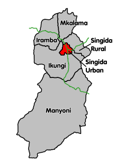
Singida Urban District is one of the six districts of the Singida Region of Tanzania. It is bordered to the south and west by the Ikungi District and to the north and east by the Singida Rural District. Its administrative seat is the town of Singida.
Tarime is a large town in northwestern Mara Region, Tanzania. The town is the location of the district capital of Tarime District. The main Tanzania-Kenyan border crossing in Sirari is less than 20km away from Tarime and can be reached by following the paved trunk road T4.
Biharamulo is a town in northwestern Tanzania. It is the district headquarter of Biharamulo District. Biharamulo used to be a German administrative centre in colonial times. Biharamulo Game Reserve is located north of the town.
Maswa is a town in Simiyu Region of Tanzania. It is the administrative seat of Maswa District. And the Original Inhabited people are Sukama (Nyantuzu).

Butiama District is one of the seven districts of Mara Region of Tanzania. Its administrative centre is the town of Butiama. Julius Nyerere was born in Butiama; the Mwalimu Nyerere Museum is located in his town of birth.

Busega District is one of the five districts of Simiyu Region of Tanzania, East Africa. Its administrative centre is the town of Nyashimo. It is bordered to the north by Lake Victoria and Bunda District, to the east by Bariadi District, and to the south by Magu District.

Nyang'hwale District is one of the five districts of Geita Region of Tanzania. Its administrative centre is the village Kharumwa. It is bordered to the north by Sengerema District, to the east by Misungwi District and Shinyanga Rural District, to the south by Kahama Rural District, and to the west by Geita District.
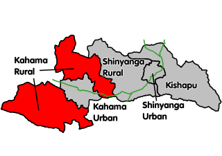
Kahama Rural District is one of the five districts of the Shinyanga Region of Tanzania. Its administrative centre is the town of Kahama. The district consists of two separate parts, divided by Kahama Urban District. The area to the northeast is Msalala Council, while the part to the southwest is Ushetu Council.

Mbogwe District is one of the five districts of Geita Region of Tanzania. It is bordered to the north by Chato District and Geita District, to the east by Kahama Rural District and Kahama Urban District, to the south by Kahama Rural District, and to the west by Bukombe District.
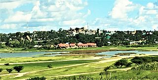
Singida is a town in central Tanzania. The town is the location of the regional headquarters of Singida Region as well as the district headquarters of Singida Urban District. The region and district are named after the town.
Makambako Urban District is one of the six districts of the Njombe Region of Tanzania. Its administrative seat is Makambako town. It is bordered to the north and east by Mufindi District, to the south by Njombe Rural District and to the west by Wanging'ombe District.

