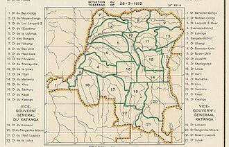
Lomami District

Last updated
Lomami District
District
Democratic Republic of the Congo adm location map.svg
Red pog.svg
Lomami District
Coordinates: 6°08′00″S24°29′00″E / 6.133333°S 24.483333°E / -6.133333; 24.483333 Coordinates: 6°08′00″S24°29′00″E / 6.133333°S 24.483333°E / -6.133333; 24.483333
CountryBelgian Congo
Province Katanga
District Lomami

Lomami District (French : District du Lomami, Dutch : District Lomami) was a district of the Belgian Congo from 1912 to 1933, when it was dissolved. It covered very roughly the same area as the present Lomami Province and the northwest of Haut-Lomami Province.

Contents

Location

Parts of the Stanley Falls and Lualaba districts were combined to form Katanga in 1910, which was called a vice-government general. [1] An arrêté royal of 28 March 1912 divided the Congo into 22 districts. [2] A map of the colony after this division shows Lomami District bordering [[Maniema District to the northeast, Tanganika-Moero District to the east, Lulua District to the south, Kasai District to the west and Sankuru District to the northwest. [3] The district was named after the Lomami River, whose upper reaches flowed northward through the district.

Katanga become a vice-government in 1913. [4] It contained the districts of Lomami, Tanganika-Moero, Lulua and Haut-Luapula. [3] In 1933 the provinces were reorganized into six provinces, named after their capitals, and the central government assumed more control. [5] Katanga became Elisabethville Province. The number of districts was reduced to 15, with 102 territories. [4] Lomami was divided among Sankuru District, Lualaba District and Tanganika District. [3]

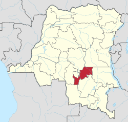
In 2015 Lomami Province was formed from the Kabinda district and the independently administered city of Mwene-Ditu. The town of Kabinda was elevated to capital city of the new province. Haut-Lomami was formed from the Haut-Lomami district, whose town of Kamina was elevated to capital city of the new province. [6]

Maps

See also

Related Research Articles

Orientale Province Province in Democratic Republic of the Congo

Orientale Province is one of the former provinces of the Democratic Republic of the Congo and its predecessors the Congo Free State and the Belgian Congo. It went through a series of boundary changes between 1898 and 2015, when it was divided into smaller units.

Lualaba District District in Katanga, Democratic Republic of the Congo

Lualaba District was a district of the pre-2015 Katanga Province in the Democratic Republic of the Congo. The district dates back to the days of the Congo Free State and the Belgian Congo. The original Lualaba District was merged into Katanga in 1910, but in 1933 a new Lualaba District was formed within Katanga. After various significant boundary changes, in 2015 the district became the western part of the present Lualaba Province.

Haut-Lomami Province of the Democratic Republic of the Congo

Haut-Lomami is one of the 21 new provinces of the Democratic Republic of the Congo created in the 2015 repartitioning. Haut-Lomami, Haut-Katanga, Lualaba, and Tanganyika provinces are the result of the dismemberment of the former Katanga province. Haut-Lomami was formed from the Haut-Lomami district whose town of Kamina was elevated to capital city of the new province.

Ituri District District in Orientale, Democratic Republic of the Congo

Ituri District, later Kibali-Ituri District, was a district of the Belgian Congo and the Democratic Republic of the Congo. It roughly corresponded in area to the present Ituri Province.

Kabinda District

Kabinda District was a district of the Belgian Congo and the Democratic Republic of the Congo. In 2015 it was merged with the independently administered city of Mwene-Ditu to form Lomami Province.

Lulua District District in Kasai-Occidental, Democratic Republic of the Congo

Lulua District was a district of the Belgian Congo and the Democratic Republic of the Congo. The city of Kananga was at the center of the district, but had a separate administration. In 2015 Lulua District became the province of Kasaï-Central.

Kasai District District in Kasaï, Democratic Republic of the Congo

Kasai District was a district of the Congo Free State, Belgian Congo and the Democratic Republic of the Congo, named after the Kasai River. It was formed around 1885 and went through several large changes in extent in the years that followed. The 1933 version of the district roughly corresponded to the former Kasai-Occidental province and the present Kasaï and Kasaï-Central provinces.

Sankuru District District in Kasaï-Oriental, Democratic Republic of the Congo

Sankuru District was a district of the Belgian Congo and Democratic Republic of the Congo. It went through various changes in extent, but roughly corresponded to the modern Sankuru Province.

Haut-Lomami District District in Katanga, Democratic Republic of the Congo

Haut-Lomami District was a district of the pre-2015 Katanga Province in the Democratic Republic of the Congo. The district dates back to the days of the Belgian Congo. At its greatest extent it roughly corresponded to the northern part of the current Lualaba Province and to the present Haut-Lomami Province.

Kwango District District in Bandundu, Democratic Republic of the Congo

Kwango District was a district of the Congo Free State, Belgian Congo and the Democratic Republic of the Congo. It went through various changes in extent. It roughly corresponded to the present provinces of Kwilu and Kwango.

Congo-Kasaï

Congo-Kasaï was one of the four large provinces of the Belgian Congo defined in 1914. It was formally established in 1919, and in 1933 was divided into the new provinces of Léopoldville and Lusambo.

Kasaï (former province)

Kasaï was a province of the Belgian Congo and the successor Republic of the Congo (Léopoldville).

Maniema District District in Orientale, Democratic Republic of the Congo

Maniema District was a district of the Belgian Congo and the Democratic Republic of the Congo. It roughly corresponded in area to the present Maniema province.

Kivu District District in Orientale, Belgian Congo

Kivu District was a district of the Belgian Congo. It was formed from part of Stanleyville District in 1914.

Districts of the Belgian Congo

The Districts of the Belgian Congo were the primary administrative divisions when Belgium annexed the Congo Free State in 1908, each administered by a district commissioner. In 1914 they were distributed among four large provinces, with some boundary changes. In 1933 the provinces were restructured into six, again with boundary changes. The number of districts fluctuated between 12 and 26 through splits and consolidations, first rising, then falling, then rising again.

Stanley Falls District District in Belgian Congo

Stanley Falls District was a district of the Congo Free State. It covered most of the eastern part of the colony along the Congo River south from Stanleyville.

Haut-Luapula District District in Katanga, Belgian Congo

Haut-Luapula District was a district of the Belgian Congo from 1912 to 1933, when it was dissolved. It roughly corresponded to the southern part of the present Haut-Katanga Province.

Tanganika-Moero District District in Katanga, Belgian Congo

Tanganika-Moero District was a district of the Belgian Congo from 1912 to 1933, when it was dissolved. It roughly corresponded to the present Tanganyika Province and the northern part of Haut-Katanga Province.

Tanganika District District in Katanga, Democratic Republic of the Congo

Tanganika District was a district of the pre-2015 Katanga Province in the Democratic Republic of the Congo. The district dates back to the days of the Belgian Congo. At its greatest extent it roughly corresponded to the present Tanganyika Province, with a small portion in the southwest now in Haut-Lomami Province.

Luapula-Moero District District in Katanga, Belgian Congo

Luapula-Moero District was a district of the pre-2015 Katanga Province in the Belgian Congo and Democratic Republic of the Congo. It roughly corresponded in area to the present Haut-Katanga Province.

References

  1. Lemarchand 1964, pp. 62–63.
  2. Lemarchand 1964, p. 63.
  3. 1 2 3 Atlas général du Congo.
  4. 1 2 Lemarchand 1964, p. 64.
  5. Bruneau 2009, p. 8.
  6. Provinces of the Democratic Republic of Congo.

Sources