Lualaba District

Last updated
Lualaba District
District
DRC Katanga Lualaba.png
Lualaba district of Katanga province (2014)
Coordinates: 9°18′S23°00′E / 9.3°S 23.0°E / -9.3; 23.0
CountryDemocratic Republic of the Congo
ProvinceKatanga
District Lualaba District

Lualaba District was a district of the pre-2015 Katanga Province in the Democratic Republic of the Congo. The district dates back to the days of the Congo Free State and the Belgian Congo. The original Lualaba District was merged into Katanga in 1910, but in 1933 a new Lualaba District was formed within Katanga. After various significant boundary changes, in 2015 the district became the western part of the present Lualaba Province.

Contents

Congo Free State

Article 3 of the decree of 16 April 1887 provided for the Congo Free State to be divided into administrative districts headed by district commissioners, assisted by one or more deputies. The decree of 1 August 1888 divided the Congo Free State into eleven districts, of which the first five were in the lower Congo region. The east of the colony was divided into Aruwimi-Uele District in the north, Stanley Falls District in the center and Lualaba District in the south, with its headquarters in Lusambo. [1] A map of the Congo Free State as of 1895 shows Lualaba District bordered by British possessions to the south and east, Stanley Falls District to the northeast, and Kasai District to the west. [2]

Belgian Congo

Belgium annexed the Congo Free State in 1908 as the Belgian Congo. Parts of the Stanley Falls and Lualaba districts were combined to form Katanga in 1910, which was called a vice-government general. [3] An arrêté royal of 28 March 1912 divided the Congo into 22 districts. [4] The vice-government of Katanga now contained the districts of Lomami and Lulua in the west, and Tanganika-Moero and Haut-Luapula in the east. [2]

The original four provinces had considerable autonomy, but in 1933 they were reorganized into six provinces, named after their capitals, and the central government assumed more control. [5] Katanga became Elisabethville Province (Katanga). The number of districts was reduced to 15, with 102 territories. [6] Elisabethville Province was divided into Lualaba in the west, and Tanganika and Haut-Katanga in the east. [2] Lualaba contained more than half the population and land area of the province. Its administrative center was the industrial town of Jadotville. [7] It took its name from the Lualaba River, which rises in the south and flows north into Tanganika District. [8]

By 1955 Lualaba had been greatly reduced in size, with the northern part of the district split off as Haut-Lomami District and part of the east transferred to Luapula-Moero District. [9] A 1955–1957 map shows Lualaba District bordering Haut-Lomami District to the north, Luapula-Moero District to the east, and British territories to the south. [9] Lualaba now had an area of 88,700 square kilometres (34,200 sq mi) out of 496,700 square kilometres (191,800 sq mi) for Katanga as a whole. [10]

Post-independence

On 11 July 1960, a few days after the Congo Republic had gained independence, the province of Katanga seceded as an independent state. In November 1961 the northern portion was reconquered by the national government and made the province of Nord-Katanga. On 21 January 1963 the remainder of Katanga was reconquered and divided into the provinces of Lualaba and Katanga Oriental. [11] Nord-Katanga, Lualaba and Katanga Oriental were merged back into the province of Katanga on 28 December 1966. [11] In 2015 the current Lualaba Province was created from the Lualaba and Kolwezi districts.

See also

Related Research Articles

<span class="mw-page-title-main">Orientale Province</span> Province in Democratic Republic of the Congo

Orientale Province is one of the former provinces of the Democratic Republic of the Congo and its predecessors the Congo Free State and the Belgian Congo. It went through a series of boundary changes between 1898 and 2015, when it was divided into smaller units.

<span class="mw-page-title-main">Kabinda District</span>

<span class="mw-page-title-main">Lulua District</span> District in Kasai-Occidental, Democratic Republic of the Congo

Lulua District was a district of the Belgian Congo and the Democratic Republic of the Congo. The city of Kananga was at the center of the district, but had a separate administration. In 2015 Lulua District became the province of Kasaï-Central.

<span class="mw-page-title-main">Équateur District</span> District in Équateur Province, Democratic Republic of the Congo

Équateur District was a former district of the Congo Free State, Belgian Congo and Democratic Republic of the Congo. In 1914 it became part of former Équateur Province. The district went through various changes of extent and name over the years. The original district roughly corresponds to the current provinces of Équateur and Tshuapa.

<span class="mw-page-title-main">Cataractes District</span> District in Kongo Central, Democratic Republic of the Congo

Cataractes District was a district located in the Kongo Central province, in the Democratic Republic of the Congo. It dated back to the days of the Congo Free State and the Belgian Congo.

<span class="mw-page-title-main">Kasai District</span> District in Kasaï, Democratic Republic of the Congo

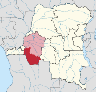
Kasai District was a district of the Congo Free State, Belgian Congo and the Democratic Republic of the Congo, named after the Kasai River. It was formed around 1885 and went through several large changes in extent in the years that followed. The 1933 version of the district roughly corresponded to the former Kasai-Occidental province and the present Kasaï and Kasaï-Central provinces.

<span class="mw-page-title-main">Haut-Lomami District</span> District in Katanga, Democratic Republic of the Congo

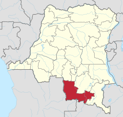
Haut-Lomami District was a district of the pre-2015 Katanga Province in the Democratic Republic of the Congo. The district dates back to the days of the Belgian Congo. At its greatest extent it roughly corresponded to the northern part of the current Lualaba Province and to the present Haut-Lomami Province.

<span class="mw-page-title-main">Kwango District</span> District in Bandundu, Democratic Republic of the Congo

Kwango District was a district of the Congo Free State, Belgian Congo and the Democratic Republic of the Congo. It went through various changes in extent. It roughly corresponded to the present provinces of Kwilu and Kwango.

<span class="mw-page-title-main">Districts of the Belgian Congo</span>

The Districts of the Belgian Congo were the primary administrative divisions when Belgium annexed the Congo Free State in 1908, each administered by a district commissioner. In 1914 they were distributed among four large provinces, with some boundary changes. In 1933 the provinces were restructured into six, again with boundary changes. The number of districts fluctuated between 12 and 26 through splits and consolidations, first rising, then falling, then rising again.

Aruwimi District was a district of the Congo Free State and Belgian Congo. It went through various changes in extent before being absorbed into other districts.

<span class="mw-page-title-main">Stanleyville District</span> District in Orientale, Democratic Republic of the Congo

Stanleyville District was a district of the Belgian Congo and Democratic Republic of the Congo. It went through various changes in extent. Between 1933 and 1963 it had roughly the same extent as the current Tshopo province.

Uele District was a district of the Congo Free State and the Belgian Congo. It roughly corresponded to the current provinces of Bas-Uélé and Haut-Uélé.

Stanley Falls District was a district of the Congo Free State. It covered most of the eastern part of the colony along the Congo River south from Stanleyville.

<span class="mw-page-title-main">Stanley Pool District</span> District in Stanley Pool, Belgian Congo

Stanley Pool District, later named Moyen-Congo District was a district of the Congo Free State and Belgian Congo. It disappeared in a reorganization of 1914.

<span class="mw-page-title-main">Districts of the Congo Free State</span>

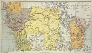
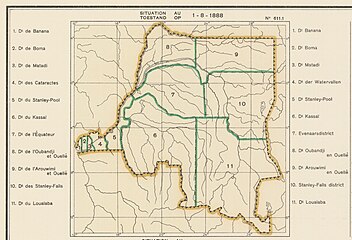
The Districts of the Congo Free State were the primary administrative divisions of the Congo Free State from 1885 to 1908. There were various boundary changes in the period before the Congo Free State was annexed by Belgium to become the Belgian Congo.

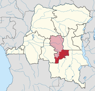
Lomami District was a district of the Belgian Congo from 1912 to 1933, when it was dissolved. It covered very roughly the same area as the present Lomami Province and the northwest of Haut-Lomami Province.

Haut-Luapula District was a district of the Belgian Congo from 1912 to 1933, when it was dissolved. It roughly corresponded to the southern part of the present Haut-Katanga Province.

Tanganika-Moero District was a district of the Belgian Congo from 1912 to 1933, when it was dissolved. It roughly corresponded to the present Tanganyika Province and the northern part of Haut-Katanga Province.

<span class="mw-page-title-main">Tanganika District</span> District in Katanga, Democratic Republic of the Congo

Tanganika District was a district of the pre-2015 Katanga Province in the Democratic Republic of the Congo. The district dates back to the days of the Belgian Congo. At its greatest extent it roughly corresponded to the present Tanganyika Province, with a small portion in the southwest now in Haut-Lomami Province.

Luapula-Moero District was a district of the pre-2015 Katanga Province in the Belgian Congo and Democratic Republic of the Congo. It roughly corresponded in area to the present Haut-Katanga Province.

References

  1. Omasombo Tshonda 2014, p. 211.
  2. 1 2 3 Atlas général du Congo.
  3. Lemarchand 1964, pp. 62–63.
  4. Lemarchand 1964, p. 63.
  5. Bruneau 2009, p. 8.
  6. Lemarchand 1964, p. 64.
  7. Higginson 1989, p. 130.
  8. Higginson 1989, p. 14.
  9. 1 2 Brass 2015, p. 243.
  10. Brass 2015, p. 254.
  11. 1 2 Congo (Kinshasa) Provinces.

Sources