Stanley Falls District

Last updated
Stanley Falls District
District
Democratic Republic of the Congo adm location map.svg
Red pog.svg
Stanley Falls District
Coordinates: 0°31′00″N25°12′00″E / 0.516667°N 25.2°E / 0.516667; 25.2 Coordinates: 0°31′00″N25°12′00″E / 0.516667°N 25.2°E / 0.516667; 25.2
CountryBelgian Congo
Province Orientale, Katanga
District Stanley Falls

Stanley Falls District (French : District des Stanley Falls, Dutch : District Stanley Falls) was a district of the Congo Free State. It covered most of the eastern part of the colony along the Congo River south from Stanleyville (present-day Kisangani).

Contents

Location

The explorer Henry Morton Stanley visited the area in 1883, and established a station that became the city of Kisangani below the Boyoma Falls, a 56 miles (90 km) series of cataracts. The river was navigable from Léopoldville up to this point. The station was known first as Falls Station and then as Stanleyville, and the falls were known as Stanley Falls. [1]

A decree of 3 September 1886 by the Congo Free State administrator general Camille Janssen defined nine districts in the colony, each headed by a district commissioner, including Stanley Falls District. [2] Article 3 of the decree of 16 April 1887 provided for the Congo Free State to be divided into administrative districts headed by district commissioners, assisted by one or more deputies. The decree of 1 August 1888 divided the Congo Free State into eleven districts including Stanley Falls District with capital at Stanley Falls. [3]

An 1897 map of the Congo Free State showed the huge Stanley Falls District where the later Stanleyville and Katanga districts would be created. [4] It covered an area of about 270,000 square miles (700,000 km2). [5] It was bounded by Uellé District to the northeast and Aruwimi District to the northwest, then by Lualaba Kassai District to the southwest. To the south and east it was bordered by English and German possessions. [4]

The district covered almost the whole Congo Basin south of the Stanley Falls. The boundary with Aruwimi District was defined by the Lomami River. From north to south, the eastern border included Lake Albert Nyassa, Lake Albert-Edward, Lake Tanganyika, Lake Moero and Lake Bangwelo. Later, Lake Bangweulu was determined to be within Northern Rhodesia. Lake Kivu was shown as contained within the district, although later it was found to be on the border between Rwanda and the Belgian Congo. [4]

A 1910 map of the Belgian Congo shows the districts after Stanley Falls District had been separated into Stanleyville District to the north and the vice-government general of Katanga to the south, with the Lualaba portion of Lualaba Kassai District transferred to Katanga. [6] The reorganization had been done that year. [7]

History

Sefu bin Hamid (center) with two officials of the Force Publique, Lieutenant Joseph Lippens and Sergeant Henri De Bruyne, at Stanley Falls, c. 1891 Sefu bin Hamid.jpg
Sefu bin Hamid (center) with two officials of the Force Publique, Lieutenant Joseph Lippens and Sergeant Henri De Bruyne, at Stanley Falls, c. 1891

In February 1887 Henry Morton Stanley arrived in Zanzibar. [8] There he met Tippu Tip, his former opponent and head of a great trading empire in the eastern Congo region. Stanley told him Leopold II of Belgium wanted to make peace with the Arabs, and offered Tippu Tip the position of governor of Stanley Falls District (the king had approved this offer by telegram, but it originated with Stanley). Tippoo Tib accepted the offer, which gave a monthly salary of £30. He promised to raise the Belgian flag and to restrain his fellow Arabs from slaving and other depredations. A European officer would be attached to him, and would make regular reports to the Belgian king. [9] King Leopold II collaborated with the Arabs at first, but disagreements arose over control of ivory and compliance with Leopold II's pledges to the Berlin Conference to end slavery. Leopold II's stance turned confrontational against his once-allies. [10]

The Congo–Arab War took place between the forces of King Leopold II of Belgium's Congo Free State and various Zanzibari Arab slave traders led by Sefu bin Hamid, the son of Tippu Tip. Fighting occurred in the eastern Congo between 1892 and 1894. It was a proxy war, with most of the fighting being done by native Congolese, who aligned themselves with either side and sometimes switched sides. [11] The causes of the war were largely economic based, since Leopold and the Arabs were contending to gain control of the wealth of the Congo. [12] In 1893 Louis-Napoléon Chaltin reached the Stanley Falls station (now Kisangani) when it was on the point of falling to the Swahilis. [13] He defeated the Arab-led forces on 18 May 1893. After defeating them again at Kirundu, the Arabs were expelled from the region. [14] The war ended in January 1894 with a victory of Leopold's Force Publique . [10]

On 15 July 1898 the Stanley Falls District became the Orientale Province, with Stanleyville as its headquarters. [14] The Apostolic Prefecture of Stanley Falls was created on 3 August 1904 out of territory taken from the Apostolic Vicariate of Congo Belge. [15]

Maps

See also

Related Research Articles

<span class="mw-page-title-main">Orientale Province</span> Province in Democratic Republic of the Congo

Orientale Province is one of the former provinces of the Democratic Republic of the Congo and its predecessors the Congo Free State and the Belgian Congo. It went through a series of boundary changes between 1898 and 2015, when it was divided into smaller units.

<span class="mw-page-title-main">Tippu Tip</span> Swahili slave trader

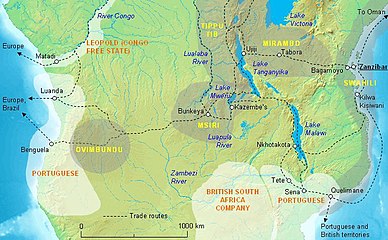
Tippu Tip, or Tippu Tib, real name Ḥamad ibn Muḥammad ibn Jumʿah ibn Rajab ibn Muḥammad ibn Saʿīd al Murjabī, was an Afro-Omani ivory and slave trader, explorer, governor and plantation owner. He worked for a succession of the sultans of Zanzibar and was the Sultan of Uterera, a short-lived state in Kasongo, Maniema ruled by himself and his son Sefu who was an Emir with local WaManyema.

Ngongo Lutete was a Congolese leader and chieftain during the late 19th century.

<span class="mw-page-title-main">Congo–Arab War</span>

The Congo–Arab War was fought in Central Africa between the forces of Belgian King Leopold II's Congo Free State and various Zanzibari Arab slave traders led by Sefu bin Hamid, Tippu Tip's son. It was a proxy war in eastern Congo from 1892 to 1894, with most of the fighting being done by native Congolese, who aligned themselves with either side and sometimes switched sides.

<span class="mw-page-title-main">Lualaba District</span> District in Katanga, Democratic Republic of the Congo

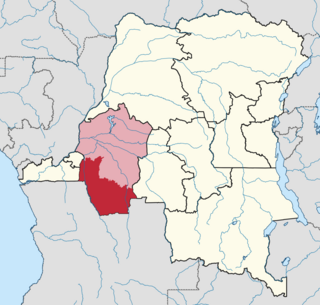
Lualaba District was a district of the pre-2015 Katanga Province in the Democratic Republic of the Congo. The district dates back to the days of the Congo Free State and the Belgian Congo. The original Lualaba District was merged into Katanga in 1910, but in 1933 a new Lualaba District was formed within Katanga. After various significant boundary changes, in 2015 the district became the western part of the present Lualaba Province.

<span class="mw-page-title-main">Équateur District</span> District in Équateur Province, Democratic Republic of the Congo

Équateur District was a former district of the Congo Free State, Belgian Congo and Democratic Republic of the Congo. In 1914 it became part of former Équateur Province. The district went through various changes of extent and name over the years. The original district roughly corresponds to the current provinces of Équateur and Tshuapa.

<span class="mw-page-title-main">Cataractes District</span> District in Kongo Central, Democratic Republic of the Congo

Cataractes District was a district located in the Kongo Central province, in the Democratic Republic of the Congo. It dated back to the days of the Congo Free State and the Belgian Congo.

<span class="mw-page-title-main">Kasai District</span> District in Kasaï, Democratic Republic of the Congo

Kasai District was a district of the Congo Free State, Belgian Congo and the Democratic Republic of the Congo, named after the Kasai River. It was formed around 1885 and went through several large changes in extent in the years that followed. The 1933 version of the district roughly corresponded to the former Kasai-Occidental province and the present Kasaï and Kasaï-Central provinces.

<span class="mw-page-title-main">Alexandre Delcommune</span>

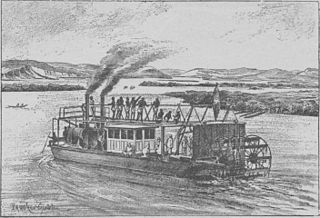
Alexandre Delcommune was a Belgian officer of the armed Force Publique of the Congo Free State who undertook extensive explorations of the country during the early colonial period of the Congo Free State. He explored many of the navigable waterways of the Congo Basin, and led a major expedition to Katanga between 1890 and 1893.

Louis-Napoléon Chaltin (1857–1933) was a Belgian career soldier and colonial official notable for his service in the Congo Free State during the late 19th century.

Muhammad bin Khalfan bin Khamis al-Barwani, commonly known as Rumaliza, was an Arab trader of slaves and ivory, active in Central and East Africa in the last part of the nineteenth century. He was a member of the Arabian Barwani tribe. With the help of Tippu Tip he became Sultan of Ujiji. At one time he dominated the trade of Tanganyika, before being defeated by Belgian forces under Baron Francis Dhanis in January 1894.

<span class="mw-page-title-main">Kwango District</span> District in Bandundu, Democratic Republic of the Congo

Kwango District was a district of the Congo Free State, Belgian Congo and the Democratic Republic of the Congo. It went through various changes in extent. It roughly corresponded to the present provinces of Kwilu and Kwango.

The following is a timeline of the history of the city of Kisangani, Democratic Republic of the Congo.

<span class="mw-page-title-main">Districts of the Belgian Congo</span>

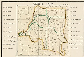
The Districts of the Belgian Congo were the primary administrative divisions when Belgium annexed the Congo Free State in 1908, each administered by a district commissioner. In 1914 they were distributed among four large provinces, with some boundary changes. In 1933 the provinces were restructured into six, again with boundary changes. The number of districts fluctuated between 12 and 26 through splits and consolidations, first rising, then falling, then rising again.

Aruwimi District was a district of the Congo Free State and Belgian Congo. It went through various changes in extent before being absorbed into other districts.

<span class="mw-page-title-main">Stanleyville District</span> District in Orientale, Democratic Republic of the Congo

Stanleyville District was a district of the Belgian Congo and Democratic Republic of the Congo. It went through various changes in extent. Between 1933 and 1963 it had roughly the same extent as the current Tshopo province.

Lowa District was a district of the Belgian Congo. It was formed from part of Stanleyville District in 1914, and had been absorbed by Maniema District and Kivu District by 1926.

Uele District was a district of the Congo Free State and the Belgian Congo. It roughly corresponded to the current provinces of Bas-Uélé and Haut-Uélé.

<span class="mw-page-title-main">Stanley Pool District</span> District in Stanley Pool, Belgian Congo

Stanley Pool District, later named Moyen-Congo District was a district of the Congo Free State and Belgian Congo. It disappeared in a reorganization of 1914.

<span class="mw-page-title-main">Districts of the Congo Free State</span>

The Districts of the Congo Free State were the primary administrative divisions of the Congo Free State from 1885 to 1908. There were various boundary changes in the period before the Congo Free State was annexed by Belgium to become the Belgian Congo.

References

  1. Kisangani Britannica.
  2. Etat Indépendant du Congo 1886, p. 194.
  3. Omasombo Tshonda 2014, p. 211.
  4. 1 2 3 Omasombo Tshonda 2015, p. 16.
  5. Lemarchand 1964, p. 62.
  6. Atlas général du Congo.
  7. Lemarchand 1964, pp. 62–63.
  8. Brode 1907, p. 195.
  9. Brode 1907, p. 196.
  10. 1 2 Nzongola-Ntalaja 2002, p. 21.
  11. Edgerton 2002, pp. 94–95.
  12. Edgerton 2002, p. 85.
  13. Ndaywel è Nziem 1998, p. 301.
  14. 1 2 Auzias & Labourdette 2006, p. 180.
  15. Metropolitan Archdiocese of Kinshasa.

Sources