
Sierra Leone, officially the Republic of Sierra Leone, is a country on the southwest coast of West Africa. It is bordered to the southeast by Liberia and by Guinea to the north. Its land area is 71,740 km2 (27,699 sq mi). It has a tropical climate and environments ranging from savannas to rainforests. As of the 2023 census, Sierra Leone has a population of 8,908,040. Freetown is both its capital and its largest city. The country is divided into five administrative regions, which are further subdivided into 16 districts.

Sherbro Island is in the Atlantic Ocean, and is included within Bonthe District, Southern Province, Sierra Leone. The island is separated from the African mainland by the Sherbro River in the north and Sherbro Strait in the east. It is 32 miles (51 km) long and up to 15 miles (24 km) wide, covering an area of approximately 230 square miles (600 km2). The western extremity is Cape St. Ann. Bonthe, on the eastern end, is the chief port and commercial centre.
Temne is a language of the Mel branch of the Niger–Congo language family. Temne speakers live mostly in the Northern Province and Western Area, Sierra Leone. Temne people can be found in a number of other West African countries as well, including Guinea and The Gambia. Some Temnes have also migrated beyond West Africa seeking educational and professional opportunities, especially in Great Britain, and the United States.
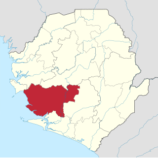
Moyamba District is a district in the Southern Province of Sierra Leone, with a population of 318,064 in the 2015 census. Its capital and largest city is Moyamba. The other major towns include Njala, Rotifunk and Shenge. The district is the largest in the Southern Province by geographical area, occupying a total area of 6,902 km2 (2,665 sq mi) and comprises fourteen chiefdoms.

The Northern Province is one of the five provincial divisions of Sierra Leone. It is located in the Northern geographic region of Sierra Leone. It comprises the following four Districts: Bombali, Falaba, Koinadugu and Tonkolili. The Northern Province covers an area of 35,936 km2 (13,875 sq mi) with a population of 2,502,865, based on the 2015 Sierra Leone national census. Its administrative and economic center is Makeni. The North borders the North West Province to the West, the Republic of Guinea to the north-east, the Eastern Province and Southern Province to the south-east.
Port Loko is the capital of Port Loko District and since 2017 the North West Province of Sierra Leone. The city had a population of 21,961 in the 2004 census and current estimate of 44,900. Port Loko lies approximately 57 km (35 mi) north-east of Freetown. The area in and around Port Loko is a major bauxite mining and trade centre. The town lies on the main highway linking Freetown to Guinea's capital Conakry. It also lies on the over-land highway between Freetown and its major airport, Lungi International Airport, although most travellers complete this journey via the much shorter ferry or helicopter transit.
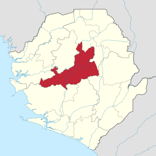
Tonkolili District is a district in the Northern Province of Sierra Leone. Its capital and largest city is Magburaka. The other major towns include Masingbi, Yele, Mile 91, Bumbuna, Yonibana, Matotoka. Mathora, Magbass and Masanga. Tonkolili District is home to the largest sugar factory in Sierra Leone, and one of the largest sugar factories in West Africa, that is located in the town of Magbass. Tonkolili District had a population of 530,776. The district occupies a total area of 7,003 km2 (2,704 sq mi) and comprises eleven chiefdoms.

The Limba people are an ethnic group in Sierra Leone. They represent 12.4% of the total population, making them the third largest ethnic group in Sierra Leone. The Limba are based in the north of the country across seven provinces, but are predominantly found in the Northern Province of Sierra Leone.
The Temne, also called Atemne, Témené, Temné, Téminè, Temeni, Thaimne, Themne, Thimni, Timené, Timné, Timmani, or Timni, are a West African ethnic group. They are predominantly found in the Northern Province of Sierra Leone. Some Temne are also found in Guinea. The Temne constitute the largest ethnic group in Sierra Leone, at 35.5% of the total population, which is slightly bigger than the Mende people at 31.2%. They speak Temne, which belongs to the Mel branch of the Niger–Congo languages.

Port Loko District is a district in the North West Province of Sierra Leone. It is the most populous district in the North and the second most populous district in Sierra Leone, after Western Area Urban District. As of the 2015 census, Port Loko District has a population of 614,063. The district capital is the town of Port Loko and its largest city is Lunsar. The other major towns in the district include Masiaka, Rokupr, Pepel, Lungi and Gbinti.

Kambia District is a district in the North West Province of Sierra Leone. Its capital and largest city is the town of Kambia. As of the 2015 census, The District had a population of 343,686. Kambia District borders the Republic of Guinea to the north, Port Loko District to the south and Karene District to the east. The district provides an important Trade route to or from the Sierra Leonean capital Freetown to the Guinean capital Conakry.
Kambia also commonly known as Kambia Town is the capital and largest town of Kambia District in the Northern Province of Sierra Leone. Kambia is a major trading town; and lies approximately 120 miles north-east of Freetown. The town had a population of 11,842 in the 2004 census, with a 2010 estimate being 12,471 and a current estimate of 40,000. Kambia is a major trading route along the main highway linking Sierra Leone's capital Freetown to Conakry, the capital of Guinea.
The Kingdom of Kquoja or Koya or Koya Temne, or the Temne Kingdom (1505–1896), was a pre-colonial African state in the north of present-day Sierra Leone.

The Western Area Rural District is one of the sixteen districts of Sierra Leone. It is located mostly around the peninsula in the Western Area of Sierra Leone. The Western Area Rural District has a 2015 census population of 442,951. The district capital and largest city is Waterloo. Other major towns in the district include Newton, Benguema, Leicester, Tombo and Regent. Most of the towns and villages in the Western Area Rural District are close to the capital Freetown and are part of the Freetown Metropolitan Area.
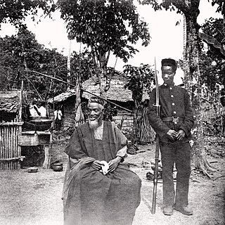
Bai Bureh was a Sierra Leonean ruler, military strategist, and Muslim cleric, who led the Temne and Loko uprising against British rule in 1898 in Northern Sierra Leone.
Lunsar is a town in Marampa Chiefdom, Port Loko District in the Northern Province of Sierra Leone. It is the largest town in Port Loko District by population. A 2004 estimate placed the population of Lunsar at 36,108. The town is one of the main commercial and business hub in the North of Sierra Leone. Lunsar lies approximately 50 miles east of Freetown and about 18 miles south-east of the district capital of Port Loko. The inhabitants of Lunsar are largely from the Temne ethnic group.

The Loko are one of the indigenous ethnic groups in Sierra Leone. Landogo is used as an endonym for the people and language, but other groups refer to them as Loko. They speak a Southwestern Mande language that is also called Loko. The majority of the Loko people live in the Northern Province of the country, particularly in Bombali District, and around the capital city of Freetown in communities such as Regent. Important regional towns include Tambiama, Kalangba, Kagbere, Batkanu, and Gbendembu, though other groups such as the Mandingo, Fula and Temne peoples live there too.

Sierra Leone is officially a secular state, although Islam and Christianity are the two main and dominant religions in the country. The Sierra Leone Government is constitutionally forbidden from establishing a state religion, though Muslim and Christian prayers are usually held in the country at the beginning of major political occasions, including presidential inauguration.

Sierra Leone is home to around sixteen ethnic groups, each with its own language. In Sierra Leone, membership of an ethnic group often overlaps with a shared religious identity. According to the 2004 census Temne is the largest ethnic group in Sierra Leone.

Karene District is a district in the North West Province, Sierra Leone. Karene is one of the sixteen districts that make up the Republic of Sierra Leone. The capital and largest city of Karene District is Kamakwie Karene along with Falaba District are the two new districts of Sierra Leone formed in December 2017, after they were ratified by the Sierra Leone Parliament in the government of former president Ernest Bai Koroma
