
Kabala is the capital and largest town of Koinadugu District in the Northern Province of Sierra Leone. Kabala is one of the main towns in Northern Sierra Leone and is set in a rural landscape, surrounded by mountains.

Makeni is the largest city in the Northern Province of Sierra Leone. The city is the capital of Bombali District, and is the economic center of the Northern Province. Makeni is the fifth largest city in Sierra Leone by population. The city of Makeni had a population of 85,116 in the 2021 census. Makeni lies approximately 110 miles east of Freetown. Makeni is home to the University of Makeni, the largest private university in Sierra Leone.

Bombali is a district in the Northern Province of Sierra Leone. Its capital and largest city is Makeni, which is also the largest city in the north. The Bombali district is one of the sixteen districts of Sierra Leone. Bombali is one of the largest districts in Sierra Leone by geographical area, after Koinadugu District, and is the second most populous district in the Northern part of Sierra Leone, after Port Loko district. In the 2015 Sierra Leone national census, the population of Bombali District was 606,183. Other major towns in Bombali District include Kamabai, Karina and Binkolo.
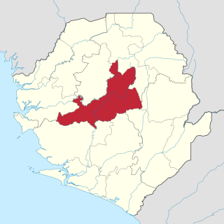
Tonkolili District is a district in the Northern Province of Sierra Leone. Its capital and largest city is Magburaka. The other major towns include Masingbi, Yele, Mile 91, Bumbuna, Yonibana, Matotoka. Mathora, Magbass and Masanga. Tonkolili District is home to the largest sugar factory in Sierra Leone, and one of the largest sugar factories in West Africa, that is located in the town of Magbass. Tonkolili District had a population of 530,776. The district occupies a total area of 7,003 km2 (2,704 sq mi) and comprises eleven chiefdoms.

Ernest Bai Koroma is a Sierra Leonean politician who served as the fourth President of Sierra Leone from 17 September 2007 to 4 April 2018.

The Limba people are an ethnic group in Sierra Leone. They represent 12.4% of the total population, making them the third largest ethnic group in Sierra Leone. The Limba are based in the north of the country across seven provinces, but are predominantly found in the Northern Province of Sierra Leone.

Port Loko District is a district in the North West Province of Sierra Leone. It is the most populous district in the North and the second most populous district in Sierra Leone, after Western Area Urban District. As of the 2015 census, Port Loko District has a population of 614,063. The district capital is the town of Port Loko and its largest city is Lunsar. The other major towns in the district include Masiaka, Rokupr, Pepel, Lungi and Gbinti.

Koinadugu District is a district in the Northern Province of Sierra Leone. It is the largest District in Sierra Leone in geographical area, and one of the least densely populated. Its capital and largest city is Kabala, which is also one of the main cities in Northern Sierra Leone. The District of Koinadugu has a population of 404,097, based on the 2015 Sierra Leone national census; and has a total area of 12,121 km2 (4,680 sq mi). Koinadugu District is subdivided into eleven chiefdoms.

Kambia District is a district in the North West Province of Sierra Leone. Its capital and largest city is the town of Kambia. As of the 2015 census, The District had a population of 343,686. Kambia District borders the Republic of Guinea to the north, Port Loko District to the south and Karene District to the east. The district provides an important Trade route to or from the Sierra Leonean capital Freetown to the Guinean capital Conakry.
Kambia also commonly known as Kambia Town is the capital and largest town of Kambia District in the Northern Province of Sierra Leone. Kambia is a major trading town; and lies approximately 120 miles north-east of Freetown. The town had a population of 11,842 in the 2004 census, with a 2010 estimate being 12,471 and a current estimate of 40,000. Kambia is a major trading route along the main highway linking Sierra Leone's capital Freetown to Conakry, the capital of Guinea.

The Loko are one of the indigenous ethnic groups in Sierra Leone. Landogo is used as an endonym for the people and language, but other groups refer to them as Loko. They speak a Southwestern Mande language that is also called Loko. The majority of the Loko people live in the Northern Province of the country, particularly in Bombali District, and around the capital city of Freetown in communities such as Regent. Important regional towns include Tambiama, Kalangba, Kagbere, Batkanu, and Gbendembu, though other groups such as the Mandingo, Fula and Temne peoples live there too.
Bumbuna is a town in the central of Tonkolili District in the Northern Province of Sierra Leone. The town lies about 30 miles from the district capital of Magburaka and approximately 124 miles northeast of Freetown.
Mandingo people of Sierra Leone is a major ethnic group in Sierra Leone and a branch of the Mandinka people of West Africa. The Mandingo first settled in what is now Sierra Leone from Guinea over 650 years ago as farmers, traders and Islamic clerics in the time of the Mali Empire, an empire under the rule of the famous Muslim ruler Mansa Musa. About 500 years later, Beginning in the late 1870s to the 1890s under the rule of prominent Mandinka Muslim cleric Samori Ture, an even larger group of Mandingo immigrated from Eastern Guinea settled in northeastern Sierra Leone on lands conqured by the Muslim ruler Samori Toure as part of the Wassoulou Empire. The Mandingo are partly responsible for the spread of Islam in Sierra Leone. The Mandingo people of Sierra Leone have a very close friendly and allied relationship with their neighbors the Mandingo people of Guinea and Liberia, as they share very similar identical dialect of the Mandingo language, tradition, culture and food.

Sierra Leone is officially a secular state, although Islam and Christianity are the two main and dominant religions in the country. The Sierra Leone Government is constitutionally forbidden from establishing a state religion, though Muslim and Christian prayers are usually held in the country at the beginning of major political occasions, including presidential inauguration.
Gbendembu is the chiefdom seat town in the Gbendembu Ngowahun Chiefdom, in the Bombali District, Northern Province of Sierra Leone. It is located about 30 miles north west of Makeni, Sierra Leone's Northern provincial city. Gbendembu is a multicultural settlement with significant number of Loko, Temne, Fula and Mandingo. The natives of Gbendembu are the Loko community, the fifth largest ethnic group in Sierra Leone, who are believed to have originated from Liberia.

Sierra Leone is home to around sixteen ethnic groups, each with its own language. In Sierra Leone, membership of an ethnic group often overlaps with a shared religious identity. According to the 2004 census Temne is the largest ethnic group in Sierra Leone.

The North West Province, also known as North Western Province, covers the northwest part of the West African state of Sierra Leone. It is one of the five administrative regions of Sierra Leone. The province was created in 2017 from the Northern Province. The three districts of Kambia, Karene and Port Loko make up the North Western Province of Sierra Leone. The province has a total of 34 Chiefdoms and a population of 1,162,065 inhabitants. The administrative capital of the North West province is Port Loko.

Falaba District is a district in the Northern Province of Sierra Leone. It is one of the sixteen districts of Sierra Leone. Its capital and largest town is Bendugu. Other towns in Falaba District include Falaba, Sikunia, Krubola, Musaia Ganya and Mansadu. Falaba District is divided into thirteen chiefdoms. Falaba District is one of the largest districts in Sierra Leone by land area, However, it is one of the least populous districts in the country. Falaba District is known for its mostly conservative Muslim population. Falaba District has a population of 205,353, based on 2018 estimate.

Karene District is a district in the North West Province, Sierra Leone. Karene is one of the sixteen districts that make up the Republic of Sierra Leone. The capital and largest city of Karene District is Kamakwie Karene along with Falaba District are the two new districts of Sierra Leone formed in December 2017, after they were ratified by the Sierra Leone Parliament in the government of former president Ernest Bai Koroma
