Koinadugu District

Last updated
Koinadugu District
All People's Congress political rally Sierra Leone 1968.jpg
The All People's Congress (APC) political rally in Kabala, Koinadugu District.
Koinadugu District in Sierra Leone 2018.svg
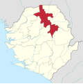
Location of Koinadugu District in Sierra Leone
Coordinates: 9°30′N11°30′W / 9.500°N 11.500°W / 9.500; -11.500
Country Sierra Leone
Province Northern Province
Capital Kabala
Largest city Kabala
Government
  TypeDistrict Council
  District Council Chairman Alex Sorie Konteh (APC)
Area
  Total12,121 km2 (4,680 sq mi)
  Rank1st
Population
 (2015 census) [1]
  Total404,097
  Density33/km2 (86/sq mi)
Time zone UTC0 (Greenwich Mean Time)
HDI (2017)0.340 [2]
low · 14th

Koinadugu District is a district in the Northern Province of Sierra Leone. It is the largest District in Sierra Leone in geographical area, and one of the least densely populated. Its capital and largest city is Kabala, which is also one of the main cities in Northern Sierra Leone. The District of Koinadugu has a population of 404,097, based on the 2015 Sierra Leone national census; [1] and has a total area of 12,121 km2 (4,680 sq mi). Koinadugu District is subdivided into eleven chiefdoms.

Contents

The District of Koinadugu borders Bombali on the west, Tonkolili District to the south-west, Kono District to the south, Falaba District to the east, and the Republic of Guinea to north east. Diamond mining is a major economic activity in the district, as well as agricultural production of rice, mango, cacao, and coconut.

The population of Koinadugu district is almost entirely made up of five main ethnic groups: the Kuranko, Mandingo, Fula, Limba, and Yalunka. These five ethnic groups are politically and culturally influential in Koinadugu District. Koinadugu District is overwhelmingly Muslim majority at over 90% and Islam dominates the religious and cultural practices in the district. There is also a small but significant minority Christian population in the district, and is mainly among the Limba people in the district.

Government

The District of Koinadugu is governed with a district council form of government, which is headed by a District Council Chairman, who is responsible for the general management of the district and for seeing that all local laws are enforced. The District Council Chairman is elected directly by the residents of Koinadugu District. The Council Hall of Koinadugu District located in the district capital of Kabala. The current chairman of Koinadugu district council is Sheku Samuel Kamara of the All People's Congress (APC). [3]

Demography

Koinadugu District is by far the largest district in Sierra Leone and with an estimated population of 265,765. The major ethnic groups in the district are the Fula (who predominate in the district's largest city of Kabala), Kuranko (who predominate in the chiefdoms), Mandingo and Limba and Yalunka (predominant in Musaia and Falaba areas bordering the republic of Guinea (Conakry)).

Religion

Religion in Koinadugu District (2015) [4]
ReligionPercent(%)
Islam
86.6%
Christianity
12.7%
Bahai
0.0%
Traditional African Religion
0.0%
Other
0.4%
No Religion
0.2%

Members of Parliament

Koinadugu District currently has 7 Representatives in the Parliament of Sierra Leone, of which one member wasn't elected to a 5-year term.

Economy

Gold mining is a major economic activity in the district, as well as agricultural productivity such as rice, mango, beans, cattle rearing, to name but few.

Administrative divisions

Chiefdoms

Pre-2017

Prior to the 2017 local administrative reorganization, Koinadugu District was made up of eleven chiefdoms as the third level of administrative subdivision.

Post-2017

After the 2017 local administrative reorganization, Koinadugu District has made up of ten chiefdoms as the third level of administrative subdivision; with the newest units in Kalian and Wollay Barawa (which would move to Falaba District), Kamadu Yirala (which would also move to Falaba District) and Kamukeh Chiefdoms being de-amalgamated from Nieni, Sengbe and Wara-Wara Bafodea Chiefdoms, the splits of Kasunko Chiefdom into Kasunko KaKellian, Gbonkobon Kayaka and Tamiso Chiefdoms, and the losses of Dembelia Sikunia, Folasaba, Mongo, Neya and Sulima Chiefdoms to the newly-created Falaba District.

Villages

See also

Related Research Articles

<span class="mw-page-title-main">Kabala, Sierra Leone</span> Place in Northern Province, Sierra Leone

Kabala is the capital and largest town of Koinadugu District in the Northern Province of Sierra Leone. Kabala is one of the main towns in Northern Sierra Leone and is set in a rural landscape, surrounded by mountains.

<span class="mw-page-title-main">Bo District</span> Place in Southern Province, Sierra Leone

Bo District is a district in the Southern Province of Sierra Leone. It is one of the sixteen Districts of Sierra Leone. Bo District is the second most populous District in Sierra Leone. Its capital and largest city is the city of Bo, which is also the second most populous city in Sierra Leone. other major towns in the district include Baoma, Bumpeh, Serabu, Sumbuya, Baiima and Yele.

Falaba is a rural town in Solima chiefdom, Falaba District in the Northern Province of Sierra Leone. The population of Falaba is largely from the Yalunka, Kuranko and couple of Mandingo ethnic groups. Falaba is virtually all Muslim and it is known for its deeply religious Muslim population. Farming is the major economic activity in Falaba.

<span class="mw-page-title-main">Bombali District</span> Place in Northern Province, Sierra Leone

Bombali is a district in the Northern Province of Sierra Leone. Its capital and largest city is Makeni, which is also the largest city in the north. The Bombali district is one of the sixteen districts of Sierra Leone. Bombali is one of the largest districts in Sierra Leone by geographical area, after Koinadugu District, and is the second most populous district in the Northern part of Sierra Leone, after Port Loko district. In the 2015 Sierra Leone national census, the population of Bombali District was 606,183. Other major towns in Bombali District include Kamabai, Karina and Binkolo.

<span class="mw-page-title-main">Northern Province, Sierra Leone</span> Province of Sierra Leone

The Northern Province is one of the five provincial divisions of Sierra Leone. It is located in the Northern geographic region of Sierra Leone. It comprises the following four Districts: Bombali, Falaba, Koinadugu and Tonkolili. The Northern Province covers an area of 35,936 km2 (13,875 sq mi) with a population of 2,502,865, based on the 2015 Sierra Leone national census. Its administrative and economic center is Makeni. The North borders the Western Area to the West, the Republic of Guinea to the north-east, the Eastern Province and Southern Province to the south-east.

<span class="mw-page-title-main">Limba people (Sierra Leone)</span> Ethnic group, third largest in Sierra Leone

The Limba people are the third largest ethnic group in Sierra Leone. They represent 12.4% of Sierra Leone's total population. They are based in the north of the country across seven provinces, comprising about 12% of the national populations. They’re predominantly found in the Northern Province of Sierra Leone.

<span class="mw-page-title-main">Kono District</span> Place in Eastern Province, Sierra Leone

Kono District is a district in the Eastern Province of Sierra Leone. Its capital and largest city is Koidu Town. Motema is the second most populous city in the district. The other major towns in the district include Yengema, Tombodu, Jaiama Nimikor and Sewafe. The district is the largest diamond producer in Sierra Leone. The population of Kono District is 505,767. Kono District borders Kenema District to the southwest, The Republic of Guinea to the east, Koinadugu District to the northeast and Kailahun District to the southeast. Kono District is divided into fourteen chiefdoms.

<span class="mw-page-title-main">Kailahun District</span> Place in Eastern Province, Sierra Leone

Kailahun District is a district in the Eastern Province of Sierra Leone. Its capital and largest city is the town of Kailahun. The second most populous city in the district is Segbwema. Other major towns in Kailahun District include Koindu, Pendembu and Daru. As of the 2015 census, the district had a population of 525,372. Kailahun District is subdivided into fourteen chiefdoms.

The Kuranko, also called Koranko, Kolanko, Kooranko, Koronko, Kouranko, Kulanko, Kurako, Kuronko, Kuranké, or Karanko, are a Mande people living that occupy a large section in a mountainous region within northeastern Sierra Leone and southern Guinea. Within this geographical region, different dialects, as well as distinct social groupings can be found. In general, the Koranko are a peaceful people who have maintained a separate ethnic identity, despite years of tribal mixings. Each Kuranko village is led by a chief and a group of elders.

<span class="mw-page-title-main">Yalunka people</span>

The Yalunka, or Dialonké, are a Mandé-speaking people who were one of the original inhabitants of the Futa Jallon, a mountainous region in Guinea, West Africa. The Yalunka people live primarily in Guinea, particularly in Faranah, while smaller communities are found in Kouroussa. Additional Yalunka are also located in northeastern Sierra Leone, southeastern Senegal, and southwestern Mali.

Mandinka people of Sierra Leone is a major ethnic group in Sierra Leone and a branch of the Mandinka people of West Africa. Most Sierra Leonean Mandingo are the direct descendants of Mandinka settlers from Guinea, who settled in the north and eastern part of Sierra Leone, beginning in the late 1870s to the 1890s under the rule of prominent Mandinka Muslim cleric Samori Ture. Also later a significantly large population of Mandinka from Guinea migrated and settled in Eastern Sierra Leone and Northern Sierra Leone in the early to mid 20th century. The Mandingo people of Sierra Leone have a very close friendly and allied relationship with their neighbors the Mandingo people of Guinea and Liberia, as they share pretty much identical dialect of the Mandingo language, tradition, culture and food.

Danda Mohamed Kondeh is a Sierra Leonean economist and politician. He is currently a member of parliament of Sierra Leone from his home district of Koinadugu. He is a member of the ruling All People's Congress (APC).

Sulima is a chiefdom in Koinadugu District of Sierra Leone with a population of 20,062. Its principal town is Falaba.

<span class="mw-page-title-main">Religion in Sierra Leone</span>

Sierra Leone is officially a secular state, although Islam and Christianity are the two main and dominant religions in the country. The constitution of Sierra Leone provides for freedom of religion and the Sierra Leone Government generally protects it. The Sierra Leone Government is constitutionally forbidden from establishing a state religion, though Muslim and Christian prayers are usually held in the country at the beginning of major political occasions, including presidential inauguration.

<span class="mw-page-title-main">Ethnic groups in Sierra Leone</span> Ethnic groups living within the country of Sierra Leone

Sierra Leone is home to about sixteen ethnic groups, each with its own language. In Sierra Leone, membership of an ethnic group often overlaps with a shared religious identity.

Madogbo is a mountainous Yalunka village in Folosaba Dembelia chiefdom in Koinadugu District in the Northern Province of Sierra Leone. The village lies about thirteen miles to Kabala, the main town in Koinadugu District. Madogbo is inhabited by the Yalunka people. The major industry in the village is farming.

<span class="mw-page-title-main">Falaba District</span> Place in Northern Province, Sierra Leone

Falaba District is a district in the Northern Province of Sierra Leone. It is one of the sixteen districts of Sierra Leone. Its capital and largest town is Bendugu. Other towns in Falaba District include Falaba, Sikunia, Krubola, Musaia Ganya and Mansadu. Falaba District is divided into thirteen chiefdoms. Falaba District is one of the largest districts in Sierra Leone in land area, However, it is one of the least most populous districts in the country. Falaba District is known for its mostly conservative Muslim population. Falaba District has a population of 205,353, based on 2018 estimate.

Bendugu is the capital and largest town of Falaba District in the Northern Province of Sierra Leone. Bendugu is a very rural town and is also the seat of Mongo Chiefdom. Bendugu is located in close proximity to the international border with the Republic of Guinea. Bendugu is about 85 miles to Kabala, and is 300 miles east of Freetown. The main economic activity in the town is farming.

Walia is a rural remote village in Mongo Chiefdom, Falaba District in the Northern Province of Sierra Leone. Walia is located at the international border with the Republic of Guinea. The main economic activity in Walia is farming. The village of Walia is extremely remote and there is no accessible road transport by vehicle to Walia village.

Folasaba Chiefdom is a chiefdom in Koinadugu District of Sierra Leone. Its capital is Musaia.

References

  1. 1 2 Regina Pratt (1 April 2016). "'Sierra Leone Population Is Now Over Seven Million'". allAfrica. Freetown. Concord Times. Retrieved 2 May 2023. (subscription required)
  2. "Sub-national HDI - Area Database - Global Data Lab". hdi.globaldatalab.org. Retrieved 2018-09-13.
  3. "Sigodi Marah Martin (Pty) Ready to Provide Pure Water for Kabala in Sierra Leone: Sierra Leone News". Archived from the original on 2008-12-05. Retrieved 2009-03-21.
  4. "Population structure. Report 1" (PDF). sierraleone.unfpa.org.