Related Research Articles

South Africa is divided into nine provinces. On the eve of the 1994 general election, South Africa's former homelands, known as Bantustans, were reintegrated into the country, and the four provinces were increased to nine by dividing Cape Province and the Transvaal into three and four, respectively. The twelfth, thirteenth and sixteenth amendments to the Constitution of South Africa changed the borders of seven of the provinces.

South Africa occupies the southern tip of Africa, its coastline stretching more than 2,850 kilometres from the desert border with Namibia on the Atlantic (western) coast southwards around the tip of Africa and then northeast to the border with Mozambique on the Indian (eastern) coast. The low-lying coastal zone is narrow for much of that distance, soon giving way to a mountainous escarpment that separates the coast from the high inland plateau. In some places, notably the province of KwaZulu-Natal in the east, a greater distance separates the coast from the escarpment. Although much of the country is classified as semi-arid, it has considerable variation in climate as well as topography. The total land area is 1,220,813 km2 (471,359 sq mi). It has the 23rd largest Exclusive Economic Zone of 1,535,538 km2 (592,875 sq mi).

The Province of the Transvaal, commonly referred to as the Transvaal, was a province of South Africa from 1910 until 1994, when a new constitution subdivided it following the end of apartheid. The name "Transvaal" refers to the province's geographical location to the north of the Vaal River. Its capital was Pretoria, which was also the country's executive capital.

Gauteng is one of the nine provinces of South Africa.

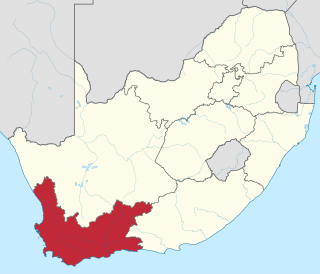
The Western Cape is a province of South Africa, situated on the south-western coast of the country. It is the fourth largest of the nine provinces with an area of 129,449 square kilometres (49,981 sq mi), and the third most populous, with an estimated 7 million inhabitants in 2020. About two-thirds of these inhabitants live in the metropolitan area of Cape Town, which is also the provincial capital. The Western Cape was created in 1994 from part of the former Cape Province. The two largest cities are Cape Town and George.

Limpopo is the northernmost province of South Africa. It is named after the Limpopo River, which forms the province's western and northern borders. The capital and largest city in the province is Polokwane, while the provincial legislature is situated in Lebowakgomo.

North West is a province of South Africa. Its capital is Mahikeng. The province is located to the west of the major population centre of Gauteng and south of Botswana.

South Africa, officially the Republic of South Africa, is the southernmost country in Africa. It is bounded to the south by 2,798 kilometres (1,739 mi) of coastline that stretches along the South Atlantic and Indian Oceans; to the north by the neighbouring countries of Namibia, Botswana, and Zimbabwe; and to the east and northeast by Mozambique and Eswatini. It also completely enclaves the country Lesotho. It is the southernmost country on the mainland of the Old World, and the second-most populous country located entirely south of the equator, after Tanzania. South Africa is a biodiversity hotspot, with unique biomes, plant and animal life. With over 62 million people, the country is the world's 23rd-most populous nation and covers an area of 1,221,037 square kilometres. Pretoria is the administrative capital, while Cape Town, as the seat of Parliament, is the legislative capital. Bloemfontein has traditionally been regarded as the judicial capital. The largest city, and site of highest court is Johannesburg.

South African National Parks (SANParks) is the body responsible for managing South Africa's national parks. SANParks was formed in 1926, and currently manages 19 parks consisting of 3,751,113 hectares (37,511.13 km2), over 3% of the total area of South Africa.
The British diaspora consists of people of English, Scottish, Welsh, Northern Irish, Cornish, Manx and Channel Islands ancestral descent who live outside of the United Kingdom and its Crown Dependencies.

The South African National Census of 2011 is the 3rd comprehensive census performed by Statistics South Africa.
St. Peters Bay is a municipality that holds community status in Prince Edward Island, Canada. It was incorporated in 1953. St. Peters Bay is well known for its annual Blueberry Festival and Parade, which draws in tourists and locals alike.
Miltonvale Park is a municipality that holds community status in Prince Edward Island, Canada. It was incorporated in 1974.
The marine protected areas of South Africa are in an area of coastline or ocean within the exclusive economic zone (EEZ) of the Republic of South Africa that is protected in terms of specific legislation for the benefit of the environment and the people who live in and use it. An MPA is a place where marine life can thrive under less pressure than unprotected areas. They are like underwater parks, and this healthy environment can benefit neighbouring areas.
The Prince Edward Island Marine Protected Area is an offshore conservation region near the Prince Edward Islands in the exclusive economic zone of South Africa, nearly 2,000 km southeast of South Africa in the Indian Ocean. The MPA provides habitat for seals, killer whales, breeding seabirds and Patagonian toothfish.
References
- 1 2 Stats in brief, 2009 (PDF). Pretoria: Statistics South Africa. 2009. p. 3. ISBN 978-0-621-38774-2 . Retrieved 14 January 2011.
- ↑ Cooper, John (June 2006). "Antarctica and Islands: Background Research Paper produced for the South Africa Environment Outlook report on behalf of the Department of Environmental Affairs and Tourism" (PDF). p. 3. Archived from the original (PDF) on 10 December 2015. Retrieved 14 January 2011.
- ↑ Stats in brief, 2000 (PDF). Pretoria: Statistics South Africa. 2000. p. 1. ISBN 0-621-29480-2 . Retrieved 14 January 2011.
- ↑ Stats in brief, 2006 (PDF). Pretoria: Statistics South Africa. 2006. p. 3. ISBN 0-621-36558-0 . Retrieved 14 January 2011.
