
Gauteng province of South Africa is divided, for local government purposes, into three metropolitan municipalities and two district municipalities. The district municipalities are in turn divided into six local municipalities.
Gauteng province of South Africa is divided, for local government purposes, into three metropolitan municipalities and two district municipalities. The district municipalities are in turn divided into six local municipalities.
| Name | Code | Seat | Area (km2) [1] | Population (2016) [2] | Pop. density (per km2) | |
|---|---|---|---|---|---|---|
| City of Ekurhuleni Metropolitan Municipality | EKU | Germiston | 1,975 | 3,379,104 | 1,710.6 | |
| City of Johannesburg Metropolitan Municipality | JHB | Johannesburg | 1,645 | 4,949,347 | 3,008.8 | |
| City of Tshwane Metropolitan Municipality | TSH | Pretoria | 6,298 | 3,275,152 | 520.0 | |
| Sedibeng District Municipality | DC42 | Vereeniging | 4,173 | 957,528 | 229.5 | |
| West Rand District Municipality | DC48 | Randfontein | 4,087 | 838,594 | 205.2 |
| Name | Code | District | Seat | Area (km2) [1] | Population (2016) [2] | Pop. density (per km2) | |
|---|---|---|---|---|---|---|---|
| Emfuleni Local Municipality | GT421 | Sedibeng | Vanderbijlpark | 966 | 733,445 | 759.3 | |
| Midvaal Local Municipality | GT422 | Sedibeng | Meyerton | 1,722 | 111,612 | 64.8 | |
| Lesedi Local Municipality | GT423 | Sedibeng | Heidelberg | 1,484 | 112,472 | 75.8 | |
| Mogale City Local Municipality | GT481 | West Rand | Krugersdorp | 1,342 | 383,864 | 286.0 | |
| Merafong City Local Municipality | GT484 | West Rand | Carletonville | 1,631 | 188,843 | 115.8 | |
| Rand West City Local Municipality | GT485 | West Rand | Randfontein | 1,115 | 265,887 | 238.5 |
These municipalities have been dissolved since the current system of local government was established in 2000.
| Name | Code | Dissolved | Fate |
|---|---|---|---|
| Metsweding District Municipality | DC46 | 18 May 2011 | Incorporated into the City of Tshwane Metropolitan Municipality |
| Nokeng tsa Taemane Local Municipality | GT461 | 18 May 2011 | |
| Kungwini Local Municipality | GT462 | 18 May 2011 | |
| Randfontein Local Municipality | GT482 | 3 August 2016 | Merged to create Rand West City Local Municipality |
| Westonaria Local Municipality | GT483 | 3 August 2016 |

The Cape Winelands District Municipality, formerly the Boland District Municipality, is a district municipality located in the Boland region of the Western Cape province of South Africa. As of 2011, it had a population of 787,490. The largest towns in the municipality are Paarl, Worcester, Stellenbosch and Wellington.
Local government in South Africa consists of municipalities of various types. The largest metropolitan areas are governed by metropolitan municipalities, while the rest of the country is divided into counties called district municipalities, each of which consists of several boroughs called local municipalities. Since the boundary reform at the time of the municipal election of 3 August 2016 there are eight metropolitan municipalities, 44 district municipalities and 205 local municipalities.

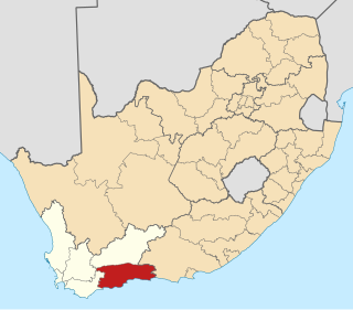
The Overberg District Municipality is a district municipality that governs the Overberg region in the Western Cape province of South Africa. It is divided into four local municipalities and includes the major towns of Grabouw, Caledon, Hermanus, Bredasdorp and Swellendam. The municipal area covers 12,241 square kilometres (4,726 sq mi) and had in 2007 an estimated population of 212,787 people in 60,056 households.

The City of Cape Town is a metropolitan municipality that forms the local government of Cape Town and surrounding areas. As of the 2016 community survey, it had a population of 4,005,016.
The Garden Route District Municipality, formerly known as the Eden District Municipality, is a district municipality located in the Western Cape province of South Africa. Its municipality code is DC4.
The nine provinces of South Africa are divided into 52 districts, which are either metropolitan or district municipalities. They are the second level of administrative division, below the provinces and above the local municipalities.
In South Africa, a local municipality or Category B municipality is a type of municipality that serves as the third, and most local, tier of local government. Each district municipality is divided into a number of local municipalities, and responsibility for municipal affairs is divided between the district and local municipalities. There are 205 local municipalities in South Africa.

The Chris Hani District Municipality is a landlocked district municipality situated in the centre of the Eastern Cape province of South Africa and is made up of eight local municipalities. Most of the communities are in rural areas. The landscape ranges from moist uplands and grassland hills to the arid Karoo scrubland.

Mbombela Municipality is a local municipality within the Ehlanzeni District Municipality, in the Mpumalanga province of South Africa. Mbombela is a siSwati word meaning "a lot of people in a small space".
The primary administrative divisions of South Africa are the nine provinces. The provinces are divided into 52 districts, which are either metropolitan or district municipalities, with the district municipalities being further divided into local municipalities. Metropolitan and local municipalities are divided into wards.
The Northern Cape province of South Africa is governed in a parliamentary system in which the people elect the provincial legislature and the legislature, in turn, elects the Premier as head of the executive. The Premier leads an Executive Council consisting of members who oversee various executive departments. The structure of the provincial government is defined by chapter six of the Constitution of South Africa.
| |||||||
| Provinces | |||||||
| Municipalities |
| ||||||
| Settlements |
| ||||||
