
Gaborone is the capital and largest city of Botswana with a population of 231,626 based on the 2011 census, about 10% of the total population of Botswana. Its agglomeration is home to 421,907 inhabitants at the 2011 census.

The population of South Africa is about 60.1 million people of diverse origins, cultures, languages, and religions. The 2011 South African census was the most recent held; the next will be in 2022.

Saskatoon is the largest city in the Canadian province of Saskatchewan. It straddles a bend in the South Saskatchewan River in the central region of the province. It is located along the Trans-Canada Yellowhead Highway, and has served as the cultural and economic hub of central Saskatchewan since its founding in 1882 as a Temperance colony.

Lethbridge is a city in the province of Alberta, Canada. With a population of 101,482 in its 2019 municipal census, Lethbridge became the fourth Alberta city to surpass 100,000 people. The nearby Canadian Rocky Mountains contribute to the city's warm summers, mild winters, and windy climate. Lethbridge lies southeast of Calgary on the Oldman River.

Jasper is a specialized municipality and townsite in western Alberta within the Canadian Rockies. The townsite is in the Athabasca River valley and is the commercial centre of Jasper National Park.

North West is a province of South Africa. Its capital is Mahikeng. The province is located to the west of the major population centre of Gauteng.

Hay River, known as "the Hub of the North," is a town in the Northwest Territories, Canada, located on the south shore of Great Slave Lake, at the mouth of the Hay River. The town is separated into two sections, a new town and an old town with the Hay River/Merlyn Carter Airport between them. The town is in the South Slave Region, and along with Fort Smith is one of the two regional centres.

The Regional Municipality of Wood Buffalo is a specialized municipality in northeast Alberta, Canada. It is the second largest municipality in Alberta by area and is home to oil sand deposits known as the Athabasca oil sands.

The Calgary Metropolitan Region (CMR), also commonly referred to as the Calgary Region, is a conglomeration of municipalities centred on Calgary, the largest city in Alberta.

Diamond Harbour is a town and a municipality of the South 24 Parganas district in the Indian state of West Bengal. It is situated on the eastern banks of the Hooghly River. It is the headquarters of the Diamond Harbour subdivision.

Port Macquarie-Hastings Council is a local government area in the Mid North Coast region of New South Wales, Australia.

Grimshaw is a town in northern Alberta located 25 km (16 mi) west of the town of Peace River at the junction of Highway 35, Highway 2, and bypass Highway 2A, and the Mackenzie Northern Railway. By virtue of being the original starting point of Highway 35, which leads to the Northwest Territories, Grimshaw is referred to as Mile Zero of the Mackenzie Highway.

Motheo was, until the municipal elections of 18 May 2011, a district of the Free State province of South Africa. At the time of the 2011 elections it was disestablished as a consequence of Mangaung Local Municipality being upgraded to a metropolitan municipality
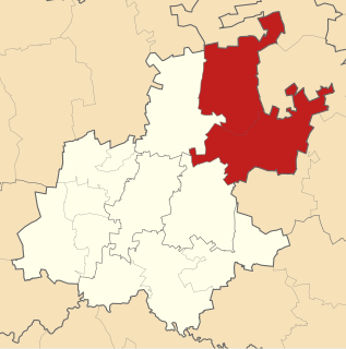
Metsweding District Municipality was, from 2000 till 18 May 2011, a district municipality in Gauteng province, South Africa. Metsweding, and its component local municipalities, was disestablished and absorbed into the Tshwane Metropolitan Municipality on the date of the 2011 municipal election.
A number of different systems of classification of ethnicity in the United Kingdom exist. These schemata have been the subject of debate, including about the nature of ethnicity, how or whether it can be categorised, and the relationship between ethnicity, race, and nationality.

Bethune is a village in the Canadian province of Saskatchewan within the Rural Municipality of Dufferin No. 190 and Census Division No. 6. The village is 56 km north-west of Regina on Highway 11. Arm River flows along a river valley north of Bethune, which features camping sites, and the Qu'Appelle River is a short way south. Last Mountain Lake or Long Lake is north-east of Bethune whereas Buffalo Pound Lake is just south-west.

Churchbridge is a town in the province of Saskatchewan, Canada, located at the junction of the Yellowhead Highway, and Highway 80. Churchbridge is a part of the rural municipality of Churchbridge 211, which is located within Saskatchewan Association of Rural Municipalities (SARM) Division No. 1 and census division Number 5.
Bushbuckridge Local Municipality(Mapulaneng) is a third-level administrative division in the Ehlanzeni District of Mpumalanga in South Africa. Commercial farming, which consists of pine /bluegum plantations, tobacco, cotton, sub-tropical fruits and vegetables is practised in the municipality's countryside. The municipality includes the southern part of the Kruger National Park. Bushbuckridge is the largest local municipality in Mpumalanga, both in terms of land size and population figures.

Kungwini Local Municipality was a local municipality in the Metsweding District of Gauteng in South Africa. The town of Bronkhorstspruit was the seat of the municipality.

