
Dewey–Humboldt is a town in Yavapai County, Arizona, United States. The population of the town was 3,894 according to the 2010 census. The Dewey–Humboldt area was a census-designated place (CDP) at the 2000 census, at which time its population was 6,295.

Kimberley is the capital and largest city of the Northern Cape Province of South Africa. It is located approximately 110 km east of the confluence of the Vaal and Orange Rivers. The city has considerable historical significance due to its diamond mining past and the siege during the Second Anglo-Boer war. British businessmen Cecil Rhodes and Barney Barnato made their fortunes in Kimberley, and Rhodes established the De Beers diamond company in the early days of the mining town.
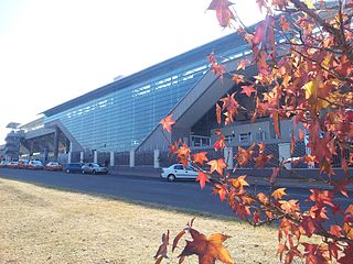
Centurion is an area with 236,580 (2011 Census) inhabitants in the Gauteng Province of South Africa, between Pretoria and Midrand (Johannesburg). Formerly an independent municipality, with its own town council, it has formed part of the City of Tshwane Metropolitan Municipality since 2000. Its heart is at the intersection of the N1 and N14 freeways. The R21 freeway also passes through the eastern part of Centurion.

Zvishavane is a mining town in Midlands Province, Zimbabwe. Surrounded by low hills, it lies 97 kilometres (60 mi) west of Masvingo, on the main Bulawayo-Masvingo road. Other roads lead from Zvishavane to Gweru, 121 kilometres (75 mi) north, and Mberengwa, 27 kilometres (17 mi) south-west. It is also on direct rail links to Gweru and Beit Bridge which then link up with Harare and Bulawayo in Zimbabwe and to Maputo in Mozambique, and Pretoria in South Africa. It has a private airport serving the city.

Springs is a former independent city, on the East Rand, now part of the Ekurhuleni in the Gauteng province of South Africa. It lies 50 km (31 mi) east of Johannesburg and 72 km (45 mi) southeast from Pretoria. The name of Springs derives from the large number of springs in the area; it has an estimated population of more than 121,610 in 2011 and is situated at 1628 m (5,340 ft) a.s.l.

Witbank, officially Emalahleni, is a city situated on the Highveld of Mpumalanga, South Africa, within the Emalahleni Local Municipality. The name Witbank is Afrikaans for "white ridge", and is named after a white sandstone outcrop where wagon transport drivers rested. The city is known for its coal-mining in the surrounding region.

Krugersdorp is a mining city in the West Rand, Gauteng Province, South Africa founded in 1887 by Marthinus Pretorius. Following the discovery of gold on the Witwatersrand, a need arose for a major town in the west of the reef. The government bought part of the Paardekraal farm and named the new town after the Transvaal president, Paul Kruger. Krugersdorp no longer has a separate municipal government after it was integrated into Mogale City Local Municipality along with surrounding towns. It is now the seat of government for Mogale City.

Cullinan is a small town in the Gauteng province of South Africa. It is located 30 km (19 mi) east of the city of Pretoria along the diamond route and is heavily reliant on tourism and the mine that dominates the skyline. The town is named after diamond magnate Sir Thomas Cullinan.

Ermelo is the educational, industrial and commercial town of the 7,750 km2 Gert Sibande District Municipality in Mpumalanga province, Republic of South Africa. It is both a mixed agriculture and mining region. It is located 210 km east of Johannesburg.

Middelburg is a large farming and industrial town in the South African province of Mpumalanga.
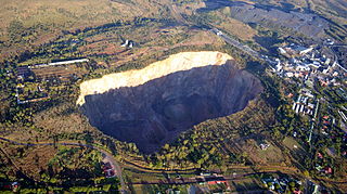
The Premier Mine is an underground diamond mine owned by Petra Diamonds in the town of Cullinan, 40 kilometres (25 mi) east of Pretoria, Gauteng Province, South Africa. Established in 1902, it was renamed the Cullinan Diamond Mine in November 2003 in celebration of its centenary. The mine rose to prominence in 1905, when the Cullinan Diamond – the largest rough diamond of gem quality ever found – was discovered there. The mine has produced over 750 stones that are greater than 100 carats (20 g) and more than a quarter of all the world's diamonds that are greater than 400 carats (80 g). It is also the only significant source of blue diamonds in the world.
The Pretoria Armour Regiment is a reserve armoured regiment of the South African Army.

The Mineral Revolution is a term used by historians to refer to the rapid industrialisation and economic changes which occurred in South Africa from the 1860s onwards. The Mineral Revolution was largely driven by the need to create a permanent workforce to work in the mining industry, and saw South Africa transformed from a patchwork of agrarian states to a unified, industrial nation. In political terms, the Mineral Revolution had a significant impact on diplomacy and military affairs. Finally, the policies and events of the Mineral Revolution had an increasingly negative impact on race relations in South Africa, and formed the basis of the apartheid system, which dominated South African society for a century. The Mineral Revolution was caused by the discovery of diamonds in Kimberly in 1867 and also by the discovery of gold in Witwatersrand in 1886. The mineral mining revolution laid the foundations of racial segregation and the control of white South Africans over black South Africans. The Mineral Revolution changed South Africa from being an agricultural society to becoming the largest gold producing country in the world.
Hans Merensky was a South African geologist, prospector, scientist, conservationist and philanthropist. He discovered the rich deposit of alluvial diamonds at Alexander Bay in Namaqualand, vast platinum and chrome reefs at Lydenburg, Rustenburg and Potgietersrus, which led to some of the largest platinum mines in the world, phosphates and copper at Phalaborwa in the Transvaal lowveld, gold in the Free State and the world's biggest chrome deposit at Jagdlust near Pietersburg.

Sir David Pieter de Villiers Graaff, 1st Baronet was a South African cold storage magnate and politician. Graaff revolutionized the cold storage industry in Africa. He founded the Imperial Cold Storage and Supply Company in 1899, and aggressively ran it until he left to serve in government. Graaff grew the company into one of the largest in Africa. Graaff's wealth soared, at the turn of the century. During World War I he personally part financed the South African war effort and for this he was knighted as well as for services at the Paris Peace Conference 1919.
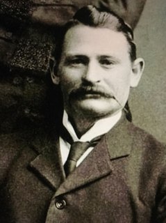
Sir Thomas Cullinan was a South African diamond magnate. He is renowned for giving his name to the Cullinan Diamond, the largest diamond ever discovered, and as owner of the Premier Mine, now renamed the Cullinan Mine, from which the famous gem was extracted on 26 January 1905. He also gave his name to the nearby South African town of Cullinan. He was honored by the African Methodist Episcopal Church in Tembisa which named their church after him. This was after he played a very big role towards building the church.

Petra Diamonds Ltd is a diamond mining group headquartered in Jersey. It has a diversified portfolio, with interests in eight producing mines in South Africa and Tanzania and an exploration programme in Botswana. Petra Diamonds' focus has shifted from exploration to production, becoming one of the largest independent producers of diamonds in Africa. In June 2012, Petra owns 5 of the world's most productive mines historically. These mines include the Cullinan Diamond Mine famed for having produced the world's largest rough and polished diamond. It is listed on the London Stock Exchange.
The following is a timeline of the history of Pretoria, in the City of Tshwane Metropolitan Municipality, Gauteng province, South Africa.

Pretoria–Maputo railway, also called Delagoa Bay railway, Iron railway and Eastern railway, is a railway that connects the city of Maputo, Mozambique, to the city of Pretoria, in South Africa. It is 567 km long, in 1067 mm gauge. The Mozambican section, between Maputo and Ressano Garcia, is managed by the state-owned Mozambique Ports and Railways (CFM) company, and it is officially known in Mozambique as the Ressano Garcia Line; in turn, on the South African stretch, between the cities of Komatipoort and Pretoria, the administration is done by the company Transnet Freight Rail.


