"},"population_total":{"wt":"2970"},"population_as_of":{"wt":"2011"},"population_density_km2":{"wt":"auto\n"},"demographics_type1":{"wt":"Racial makeup (2011)"},"demographics1_footnotes":{"wt":""},"demographics1_title1":{"wt":"[[Bantu peoples of South Africa|Black African]]"},"demographics1_info1":{"wt":"71.6%"},"demographics1_title2":{"wt":"[[Coloureds|Coloured]]"},"demographics1_info2":{"wt":"4.9%"},"demographics1_title3":{"wt":"[[Indian South African|Indian]]/[[Asian South African|Asian]]"},"demographics1_info3":{"wt":"2.1%"},"demographics1_title4":{"wt":"[[White South African|White]]"},"demographics1_info4":{"wt":"20.9%"},"demographics1_title5":{"wt":"Other"},"demographics1_info5":{"wt":"0.5%\n"},"demographics_type2":{"wt":"[[First language]]s (2011)"},"demographics2_footnotes":{"wt":""},"demographics2_title1":{"wt":"[[English language|English]]"},"demographics2_info1":{"wt":"15.6%"},"demographics2_title2":{"wt":"[[Northern Sotho language|Northern Sotho]]"},"demographics2_info2":{"wt":"15.3%"},"demographics2_title3":{"wt":"[[Afrikaans]]"},"demographics2_info3":{"wt":"15.1%"},"demographics2_title4":{"wt":"[[Tswana language|Tswana]]"},"demographics2_info4":{"wt":"10.2%"},"demographics2_title5":{"wt":"Other"},"demographics2_info5":{"wt":"43.9%\n\n"},"timezone1":{"wt":"[[South African Standard Time|SAST]]"},"utc_offset1":{"wt":"+2"},"postal_code_type":{"wt":"[[List of postal codes in South Africa|Postal code]] (street)"},"postal_code":{"wt":""},"postal2_code_type":{"wt":"[[Post-office box|PO box]]"},"postal2_code":{"wt":""},"area_code_type":{"wt":"[[Telephone numbers in South Africa|Area code]]"}},"i":0}}]}" id="mwBA">Place in Gauteng, South Africa
Prinshof | |
---|---|
![]() Prinshof | |
Coordinates: 25°44′02″S28°11′56″E / 25.734°S 28.199°E Coordinates: 25°44′02″S28°11′56″E / 25.734°S 28.199°E | |
Country | South Africa |
Province | Gauteng |
Municipality | City of Tshwane |
Main Place | Pretoria |
Area | |
• Total | 1.46 km2 (0.56 sq mi) |
Population (2011) [1] | |
• Total | 2,970 |
• Density | 2,000/km2 (5,300/sq mi) |
Racial makeup (2011) | |
• Black African | 71.6% |
• Coloured | 4.9% |
• Indian/Asian | 2.1% |
• White | 20.9% |
• Other | 0.5% |
First languages (2011) | |
• English | 15.6% |
• Northern Sotho | 15.3% |
• Afrikaans | 15.1% |
• Tswana | 10.2% |
• Other | 43.9% |
Time zone | UTC+2 (SAST) |
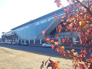
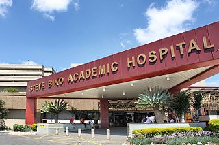
Prinshof is an area in Pretoria. It is the home of the Faculty of Health Sciences of the University of Pretoria and the Steve Biko Hospital (formerly the Pretoria Academic Hospital).
Prinshof is also the name of a school in Pretoria for partially sighted children.
Marabastad is a business area near the city centre of Pretoria, South Africa. The original Maraba Village, situated just to the south of the present Marabastad, was founded and ruled by the Ndebele Chief Maraba. The name Marabastad is the Afrikaans word meaning Maraba City.
Centurion is an area with 236,580 (2011 Census) inhabitants in Gauteng Province of South Africa, located between Pretoria and Midrand (Johannesburg). Formerly an independent municipality, with its own town council, it has formed part of the City of Tshwane Metropolitan Municipality since 2000. Its heart is located at the intersection of the N1 and N14 freeways. The R21 also passes through Centurion.
The South African Military Health Service is the branch of the South African National Defence Force responsible for medical facilities and the training and deployment of all medical personnel within the force. Though unusual, as most national militaries integrate their medical structures into their existing service branches, the SANDF regards this structure as being the most efficient method of providing care and support to the SANDF's personnel.
Thaba Tshwane is a military base, in Pretoria, South Africa.
Mamelodi, part of the City of Tshwane Metropolitan Municipality, is a township set up by the then apartheid government northeast of Pretoria, Gauteng, South Africa.
Steve Biko Academic Hospital of Pretoria, South Africa, previously located at what is now Tshwane District Hospital, is a purely tertiary training healthcare institution. It is the main teaching hospital of the University of Pretoria along with Kalafong Hospital in Atteridgeville to west of the city centre.
Ga-Rankuwa is a township located about 37 km north of Pretoria. Provincially it falls Gauteng province, but it used to be under North West Province, as it belonged to Bophuthatswana, ruled by Lucas Mangope, during the apartheid years.
Tshwane District Hospital is situated in Prinshof 349-Jr, a suburb of Pretoria, South Africa. It was known as H. F. Verwoerd Hospital until 1994, but is now a separate community hospital that deals with non-critical care.
The Onderstepoort Veterinary Academic Hospital (OVAH) was established by the University of Pretoria and provides clinical veterinary services with full student participation. It is situated on the Faculty of Veterinary Science campus at Onderstepoort. All hours tel number: 086 100 8387 and follow the prompts.
The Diocese of St Mark the Evangelist is a diocese in the Anglican Church of Southern Africa, in the geographical area of the Limpopo province in the north of South Africa.
Leslie Edward Wostall Codd, was a South African plant taxonomist.
Kalafong Hospital is a public hospital in Pretoria, Gauteng. The hospital is situated on the western outskirts of Pretoria in the suburb of Atteridgeville. The University of Pretoria uses the hospital as a training institution for the Faculty of Health Sciences.
Weskoppies, colloquially known as Groendakkies, is a public psychiatric hospital in Pretoria, Gauteng. It is situated to the west of the city centre and was built on the site of the old botanical gardens.
TS Pretoria was a ship that had a long and varied career as first a German cargo liner, then a U-boat depot ship, hospital ship, British troop ship, Muslim pilgrim ship and finally an Indonesian naval accommodation ship.
Livingstone Hospital is a large Provincial government-funded hospital situated in Korsten, Port Elizabeth in South Africa. It is a tertiary hospital and forms part of the Port Elizabeth Hospital Complex.
Danville is a predominantly White suburb, to the west of central Pretoria, in the City of Tshwane Metropolitan Municipality.
Capital Park is one of Pretoria's oldest and first suburbs and lies approximately 4 km north of the historic Church Square, behind the Pretoria National Zoo. The neighbourhood is bordered by the Witwatersberge on the south side and the Apies River on the west side. The neighbourhood extends from the Apies River to Voortrekkers Street. Streets in the neighbourhood are named after early mayors of Pretoria. One of the former mayoral residences is in Capital Park. Capital Park was previously a very popular neighbourhood among Italian as well as Portuguese communities - the Portuguese Church is still in Van Heerden Street (2010). The residential area today is cosmopolitan, with predominantly Afrikaans speaking inhabitants. The CPRTA functions as residents' association to look after the interests of its residents.
![]() | This Gauteng location article is a stub. You can help Wikipedia by expanding it. |