This article relies largely or entirely on a single source .(June 2017) |
Lukasrand | |
|---|---|
 View over Lukasrand | |
 Lukasrand  Lukasrand | |
| Coordinates: 25°45′58″S28°12′20″E / 25.76611°S 28.20556°E | |
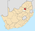
| Country | South Africa |
| Province | Gauteng |
| Municipality | City of Tshwane |
| Established | 1961 |
| Area | |
• Total | 0.37 km2 (0.14 sq mi) |
| Population (2011) [1] | |
• Total | 439 |
| • Density | 1,200/km2 (3,100/sq mi) |
| Time zone | UTC+2 (SAST) |
| Postal code (street) | 0181 |
| Area code | 012 |
Lukasrand is an established suburb to the southeast of Pretoria, South Africa.