Pretoria is South Africa's administrative capital, serving as the seat of the executive branch of government, and as the host to all foreign embassies to South Africa.

Paarl is a town with 112,045 inhabitants in the Western Cape province of South Africa. It is the third-oldest city and European settlement in the Republic of South Africa and the largest town in the Cape Winelands. Due to the growth of the Mbekweni township, it is now a de facto urban unit with Wellington. It is situated about 60 kilometres (37 mi) northeast of Cape Town in the Western Cape Province and is known for its scenic environment and viticulture and fruit-growing heritage.
Centurion is an area with 236,580 inhabitants in the Gauteng Province of South Africa, between Pretoria and Midrand. Formerly an independent municipality, with its own town council, it has been part of the City of Tshwane Metropolitan Municipality since 2000. Its heart is at the intersection of the N1 and N14 freeways. The R21 freeway also passes through the eastern part of Centurion.

Vanderbijlpark is an industrial city with approximately 95 000 inhabitants, situated on the Vaal River in the south of Gauteng province, South Africa. The city is named after Hendrik van der Bijl, an electrical engineer and industrialist.
Randpark is a suburb of the city of Johannesburg, South Africa. It is located in the northern suburbs of the City of Johannesburg.

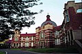
Pretoria Boys High School is a semi-private, tuition charging, English medium high school for boys situated in the suburb of Brooklyn in Pretoria in the Gauteng province of South Africa, founded in 1901 by Alfred Milner, 1st Viscount Milner.

Waterkloof is an affluent suburb of the city of Pretoria in the Gauteng province of South Africa, located to the east of the city centre. It is named after the original farm that stood there when Pretoria was founded in the 19th Century.

Afrikaanse Hoër Meisieskool Pretoria is a public, Afrikaans medium high school for girls situated in the suburb of Clydesdale in Pretoria in the Gauteng province of South Africa. It is the sister school of the Afrikaanse Hoër Seunskool.

Groenkloof is a residential suburb of Pretoria, South Africa.

The Van Wouw House, was the last residence of the South African artist Anton Van Wouw.

Anton van Wouw was a Dutch-born South African sculptor regarded as the father of South African sculpture.

Wynberg is a southern suburb of the City of Cape Town in Western Cape, South Africa. It is situated between Plumstead and Kenilworth, and is a main transport hub for the Southern Suburbs of Cape Town.
Menlo Park is an upmarket suburb in the city of Pretoria, South Africa. It borders other upmarket areas Waterkloof, Brooklyn and Lynnwood. When it was first established between the 1950s and 1960s, it was the most eastern suburb of Pretoria, but the city has since considerably expanded eastwards. Today these suburbs are known as the Old East and can boast to have some of the city's most high-end residential properties.

Arcadia is a suburb in Pretoria, South Africa that is known for its historical buildings, embassies and hotels. The Union Buildings and the President's residence are also situated here.

The University of Pretoria is a multi-campus public research university in Pretoria, the administrative and de facto capital of South Africa. The university was established in 1908 as the Pretoria campus of the Johannesburg-based Transvaal University College and is the fourth South African institution in continuous operation to be awarded university status. The university has grown from the original 32 students in a single late Victorian house to approximately 53,000 in 2019. The university was built on seven suburban campuses on 1,190 hectares.

Pretoria North is a suburb of the city of Pretoria, Gauteng, South Africa, with a population of 16,972 people according to the 2011 census.

Hoërskool Voortrekker is a public Afrikaans medium co-educational high school situated in the municipality of Boksburg in the city of Ekurhuleni in the Gauteng province of South Africa. The academic school was established in 1920.
The following is a timeline of the history of Pretoria, in the City of Tshwane Metropolitan Municipality, Gauteng province, South Africa.

The Statue of Paul Kruger is a bronze sculpture located in Church Square in Pretoria, South Africa. The statue depicts Paul Kruger, the Boer political and military leader and President of the South African Republic from 1883 to 1900, and four unnamed Boer soldiers. The Statue of Paul Kruger was sculpted in 1896 and was installed in its current location in Church Square in 1954.

Lynnwood Glen is a suburb of the city of Pretoria, South Africa. It is a well-developed area, lying to the east of the city centre.