Marabastad, Pretoria

Last updated
Marabastad
National Cultural History Museum-139.jpg
Marabastad exhibition in the National Cultural History museum in Boom street, Pretoria
South Africa Gauteng location map.svg
Red pog.svg
Marabastad
South Africa adm location map.svg
Red pog.svg
Marabastad
Africa location map.svg
Red pog.svg
Marabastad
Coordinates: 25°44′28″S28°10′33″E / 25.7410°S 28.1759°E / -25.7410; 28.1759
Country South Africa
Province Gauteng
Municipality City of Tshwane
Main Place Pretoria
Area
[1]
  Total0.57 km2 (0.22 sq mi)
Population
 (2011) [1]
  Total339
  Density590/km2 (1,500/sq mi)
Racial makeup (2011)
[1]
   Black African 93.2%
   Coloured 1.5%
   Indian/Asian 0.3%
   White 0.3%
  Other4.7%
First languages (2011)
[1]
   English 15.8%
   Xhosa 12.5%
   Tsonga 11.1%
   Southern Ndebele 6.1%
  Other54.5%
Time zone UTC+2 (SAST)
Postal code (street)
0002

Marabastad (also called Asiatic Bazaar or Location) is a business area to the west of the city centre of Pretoria, South Africa. The original Maraba Village, situated just to the south of the present Marabastad, was founded and ruled by the Ndebele Chief Maraba. The name Marabastad is the Afrikaans word meaning Maraba's Town.

Contents

Background

Marabastad was a culturally diverse community, with the Hindu Mariamman Temple arguably being its most prominent landmark. Like the residents of other racially diverse areas in South Africa, such as District Six, "Fietas" and Sophiatown, the inhabitants of Marabastad were relocated to single-race townships further away from the city centre. These removals were due to Apartheid laws like the Group Areas Act. Unlike Sophiatown, Fietas and District Six, it was not bulldozed, but it retained many of its original buildings, and became primarily a business district, with most shops still owned by the Indians who had also lived there previously. Some property was however owned by the city council and the government, resulting in limited development taking place there. In addition, a large shopping complex was built to house Indian-owned shops.

The black residents of Marabastad were relocated to Atteridgeville (1945), the Coloured residents to Eersterus (1963), and the Indian residents to Laudium (1968). There are plans to revive once-picturesque Marabastad, and to reverse years of urban decay and neglect, although few seem to have been implemented as of 2005.

History

Marabastad was named after the local headman of a village to the west of Steenhoven Spruit. During the 1880s he lived in Schoolplaats and acted as an interpreter. During this period some Africans lived on the farms where they were being employed and also chose to live on other, undeveloped land. Schoolplaats could also not accommodate all the migrants and this resulted in squatting.

An overflow from Schoolplaats to the north-west and Maraba's village occurred and in August 1888 the land was surveyed by the government. The location Marabastad was established and was situated between the Apies River in the north, Skinner Spruit in the west, Steenhoven Spruit in the east and De Korte Street in the south. There were 67 stands varying between 1400 and 2500 square meters each. Residents were not allowed to own stands, but had to rent them from the government at 4 pounds a year. They were allowed to build their own houses and to plant crops on empty plots. Water was acquired from the various bordering rivers and 58 wells situated in the area.

The township was not private owned and was managed by the Transvaal Boer Republic. At the outbreak of the Second Boer War in 1899 there were no rules and regulations with regard to Marabastad. Africans who streamed to Pretoria during the war were living in squatter camps near the artillery barracks, the brickworks and the railway stations at Prinshof. This resulted in the development of ‘New Marabastad’ in the area between Marabastad and the Asiatic Bazaar in 1900 by the British military authorities. They had been occupying the city since June 1900 and resettled refugees in the area. By 1901 there were 392 occupied stands in the New Marabastad and there was no real segregation between Africans, Indians and Coloured people.

Although New Marabastad was intended as a temporary settlement the military authorities granted permission for in their employ to erect brick houses. This resulted in the erection of other permanent structures like schools and churches. The new Town Council was established in 1902 and it was accepted that the residents of New Marabastad would be moved to other, planned townships. In 1903 New Marabastad had grown to 412 stands while Old Marabastad still only had 67. Along with the Cape Location, which was situated in the southern part of the Asiatic Bazaar, it fell under the jurisdiction of the City Council of that year. The greatest problem was the provision of water and this was only addressed after the war. Due to the fear of epidemic all wells in the area had been filled during the war, and a single public tap had replaced the entire system. New Marabastad didn't have any wells or taps. There was an attempt to rectify this in 1903 by providing more taps, but the number was still inadequate.

In 1906 New and Old Marabastad became one location. Rates were determined and sanitary and building regulations came into effect. These regulations didn't achieve their objections as a result of municipal maladministration and the fact that Africans could not own land and afford well-built permanent houses. Streets remained unpaved, the water supply was inadequate and there were no sanitary facilities worth mentioning. More and more shacks appeared. By 1907 conditions improved marginally, but the streets were left in their unkempt state and by 1910 this had still not been addressed. The Native Affairs Department accused the Pretoria Town Council of inefficient administration, which had led directly to this situation.

Removals

The relocation of residents of Old Marabastad had been on the agenda of the town council since 1903 and in 1907, when the council decided to build a new sewage farm, it became a reality. It was decided to remove all residents of the area to a new location further away from the city centre and to demolish the old township. Now followed the struggle of finding a suitable site. The site on the southern slope of Daspoortrand was decided on in 1912 and in January planning for the ‘New Location’ started. It would include a number of brick houses that could be rented from the municipality. By September of the same year the first relocations were taking place and demolishing of old structures commenced. It was a slow process and Old Marabastad was only completely destroyed by 1920.

The lack of space remained a problem and New Marabastad was experiencing severe overcrowding. By 1923 the last houses of the second municipal project was completed in New Location and Marabastad residents who had been exposed to the worst conditions were allowed to move in first. In 1934 part of the Schoolplaats population was moved to Marabastad and the squatter problem became more severe. There was no room for expansion due to a lack of space.

An attempt to solve these problems manifested itself in the establishment of Atteridgeville in 1939. The Marabastad community would be moved here and compensation was offered to previous owners of property in the form of new houses they could rent, but not own. The war slowed the process considerably, but 1949 had moved three quarters of the population of Marabastad to Atteridgeville, and by 1950 the transition was complete.

Related Research Articles

Sharpeville is a township situated between two large industrial cities, Vanderbijlpark and Vereeniging, in southern Gauteng, South Africa. Sharpeville is one of the oldest of six townships in the Vaal Triangle. It was named after John Lillie Sharpe who came to South Africa from Glasgow, Scotland, as secretary of Stewarts & Lloyds. Sharpe was elected to the Vereeniging City Council in 1932 and held the position of mayor from 1934 to 1937.

Laudium is an Indian township southwest of central Pretoria, in the City of Tshwane Metropolitan Municipality. Claudius is a residential suburb that is effectively an extension of Laudium.

<span class="mw-page-title-main">History of Johannesburg</span> Aspect of history

Johannesburg is a large city in Gauteng Province of South Africa. It was established as a small village controlled by a Health Committee in 1886 with the discovery of an outcrop of a gold reef on the farm Langlaagte. The population of the city grew rapidly, becoming a municipality in 1898. In 1928 it became a city making Johannesburg the largest city in South Africa. In 2002 it joined ten other municipalities to form the City of Johannesburg Metropolitan Municipality. Today, it is a centre for learning and entertainment for all of South Africa. It is also the capital city of Gauteng.

<span class="mw-page-title-main">Sophiatown</span> Suburb of Johannesburg

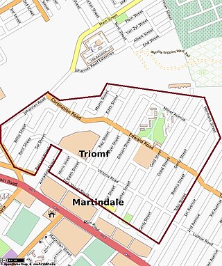
Sophiatown, also known as Sof'town or Kofifi, is a suburb of Johannesburg, South Africa. Sophiatown was a black cultural hub that was destroyed under apartheid, It produced some of South Africa's most famous writers, musicians, politicians and artists. Rebuilt under the name of Triomf, and in 2006 officially returned to its original name. Sophiatown was one of the oldest black areas in Johannesburg and its destruction represents some of the excesses of South Africa under apartheid.

Meadowlands is a suburb of Soweto, Gauteng Province, South Africa. It was founded in the early 1950s during the apartheid era for black residents from Sophiatown.

<span class="mw-page-title-main">Mamelodi</span> Place in Gauteng, South Africa

Mamelodi, part of the City of Tshwane Metropolitan Municipality, is a township set up by the then apartheid government northeast of Pretoria, Gauteng, South Africa.

Chinese South Africans are Overseas Chinese who reside in South Africa, including those whose ancestors came to South Africa in the early 20th century until Chinese immigration was banned under the Chinese Exclusion Act of 1904. Chinese industrialists from the Republic of China (Taiwan) who arrived in the 1970s, 1980s and early 1990s, and post-apartheid immigrants to South Africa now outnumber locally-born Chinese South Africans.

<span class="mw-page-title-main">Pageview, Johannesburg</span> Place in Gauteng, South Africa

Pageview is a suburb of Johannesburg, South Africa. It is located in Region F of the City of Johannesburg Metropolitan Municipality. Populated by non-whites, predominantly Indians, until the 1970s, it was one of two adjacent suburbs commonly known as Fietas.

Louis Botha Avenue is a major street in Johannesburg, South Africa. Originally part of the main road between central Johannesburg and Pretoria, it runs along through the north-eastern parts of the city from Hillbrow to Sandton, passing through numerous older suburbs, including Houghton and Orange Grove, before it becomes the Pretoria Main Road (R101) which passes the Alexandra Township and continues to Midrand and Pretoria.

Atteridgeville is a township located to the west of Pretoria, South Africa. It is located to the east of Saulsville, to the west of West Park; to the north of Laudium and to the south of Lotus Gardens. The settlement was established in 1939, and is named after Mrs MP Atteridge, chairwoman of the Committee for Non-European Affairs on the Pretoria City Council at the time. The Lucas Masterpieces Moripe Stadium is located in Atteridgeville.

<span class="mw-page-title-main">Thembisa</span> Place in Gauteng, South Africa

Thembisa, formerly Tembisa, is a large township situated to the north of Kempton Park on the East Rand, Gauteng, South Africa. It was established in 1957 when black people were resettled from Alexandra and other areas in Edenvale, Kempton Park, Midrand and Germiston.

Ga-Rankuwa is a large settlement located about 37 km north-west of Pretoria. Provincially it is in Gauteng province, but it used to fall in Bophuthatswana during the apartheid years, and under the North West province until the early 2000s.

Randpark Ridge is an upmarket suburb of Randburg, South Africa. It is located in the Randburg region of the City of Johannesburg. It fell into the town of Randburg during the apartheid era. Developed in the early 1980s and still relatively new, Randpark Ridge is bordered by several other suburbs including Weltevreden Park, Sundowner, Boskruin, Bromhof, Honeydew and Fairland. It is located on the north-west extremity of Johannesburg.

The 1957 Alexandra bus boycott was a protest undertaken against the Public Utility Transport Corporation (PUTCO) by the people of Alexandra in Johannesburg, South Africa.

Mabopane is a residential township in South Africa. It is situated in the Tshwane Metropolitan Municipality, to the north of Pretoria in Gauteng.

<span class="mw-page-title-main">Oriental Plaza</span> Shopping centre in Johannesburg, South Africa

The Oriental Plaza, known locally as the Plaza is a large shopping centre and tourist attraction in Fordsburg, a suburb of Johannesburg, South Africa. Consisting of multiple connected malls, it was created for Indian traders who were forcibly removed from nearby Fietas by the apartheid government.

Moreleta Park is a suburb of Pretoria, South Africa, situated 12 kilometres (7 mi) southeast of the city centre. According to the 2011 census, it has a population of 27,539.

<span class="mw-page-title-main">Fietas Museum</span>

Fietas Museum was opened on 24 September 2013, the museum is located in Pageview, Gauteng, South Africa. The building that the museum is housed in is one of the few to survive the forced removals under the Group Areas Act and was declared a Heritage resource in 2007.

Lotus Gardens is a small suburb situated next to Atteridgeville in the west of Pretoria.

<span class="mw-page-title-main">Slum clearance in South Africa</span> Urban renewal strategy in South Africa

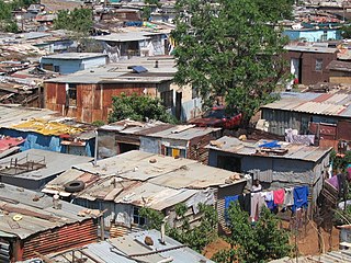
Slum clearance in South Africa has been used as an urban renewal strategy to regenerate derelict or run-down districts, often to be replaced with alternative developments or new housing.

References

  1. 1 2 3 4 "Sub Place Marabastad". Census 2011.