
Pretoria is South Africa's administrative capital, serving as the seat of the executive branch of government, and as the host to all foreign embassies to South Africa.
Centurion is an area with 236,580 inhabitants in the Gauteng Province of South Africa, between Pretoria and Midrand. Formerly an independent municipality, with its own town council, it has been part of the City of Tshwane Metropolitan Municipality since 2000. Its heart is at the intersection of the N1 and N14 freeways. The R21 freeway also passes through the eastern part of Centurion.

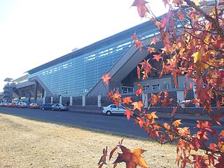
Air Force Base Waterkloof {AFB Wklf} is an airbase of the South African Air Force. It is situated on the outskirts of Pretoria, and is the SAAF's busiest airbase. The base's name, Waterkloof, is Afrikaans. It means Water Ravine in English. Despite the name, this base is not located in Waterkloof, Pretoria, but lies to the south of Pretoria, 4.34 nmi (8.04 km) to the northeast of Centurion, Gauteng and 3.37 nmi (6.24 km) from AFB Swartkop, at an elevation of 1506 metres (4940 ft).

The R50 is a provincial route in South Africa that connects Pretoria with Standerton via Delmas and Leandra.

Pretoria Boys High School is a semi-private, tuition charging, English medium high school for boys situated in the suburb of Brooklyn in Pretoria in the Gauteng province of South Africa, founded in 1901 by Alfred Milner, 1st Viscount Milner.

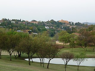
Waterkloof is an affluent suburb of the city of Pretoria in the Gauteng province of South Africa, located to the east of the city centre. It is named after the original farm that stood there when Pretoria was founded in the 19th Century.

Brooklyn is a suburb of the city of Pretoria, South Africa. It is a well-established and wealthy area, lying to the east of the city centre, encompassing high-end residential properties and several upmarket mall developments. It borders the University of Pretoria to its north and the suburbs of Groenkloof and Waterkloof to its south. Brooklyn is also the location of Pretoria Boys High School. The Brooklyn Mall opened in 1989.
Menlo Park is an upmarket suburb in the city of Pretoria, South Africa. It borders other upmarket areas Waterkloof, Brooklyn and Lynnwood. When it was first established between the 1950s and 1960s, it was the most eastern suburb of Pretoria, but the city has since considerably expanded eastwards. Today these suburbs are known as the Old East and can boast to have some of the city's most high-end residential properties.
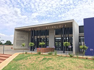
Hoërskool Waterkloof is a public Afrikaans medium co-educational high school situated in the eastern suburbs of Pretoria in the Gauteng province of South Africa. It is one of the most expensive Afrikaans medium schools, the fee per child amounting to R 32,400 per annum. It has received the award for academic school of the year from the Gauteng Department of Education (GDE) in 2004, 2008, 2009, 2010, 2011 and 2012. In 2018, it received the award for best academic school in Gauteng province, the ninth time since 2009. It claims a 100% matric pass rate for 30 consecutive years.

Air Force Base Swartkop is South Africa's oldest air force base and houses the South African Air Force Museum. It is managed as part of AFB Waterkloof and houses one of the three branches of the South African Air Force Museum. The name of the air force base, Swartkop means Black hill in Afrikaans.
Constantia Park is a residential suburb in the city of Pretoria in the Gauteng province of South Africa. It borders other upmarket areas like Erasmuskloof, Garsfontein, Waterkloof Glen and Lynnwood Glen.
Pierre van Ryneveld Park is a suburb of Centurion in Gauteng Province, South Africa. It is named after Sir Pierre van Ryneveld. It is bisected by the N1 freeway and is bordered by Pretoria's South Eastern suburbs Waterkloof Ridge, Elardus Park and Monument Park.
Waterkloof Ridge is a residential suburb of the city of Pretoria, South Africa. Originally called Highlands - where so called Coloureds, Blacks & some Indians lived & schooled - before they were displaced to 'separate development areas' as per the South African National Party Apartheid system, Waterkloof is located to the south of Waterkloof in a leafy area that contains some of the city's most expensive real estate, as is the case in much of the surrounding region.
Waterkloof Glen is a suburb of the city of Pretoria, South Africa. Located to the east of Waterkloof in a leafy, established area that is home to some good real estate.
Waterkloof Park is a tiny suburb of the city of Pretoria, South Africa. Located southeast of Waterkloof, it is home to some of the city's most expensive real estate.
Claremont is a suburb of Johannesburg, South Africa, around 9 km west-northwest of City Hall. Under the old municipal borders, it was one of the westernmost suburbs of the city and bordered Roodepoort.
The M57 is a major metropolitan route in Greater Johannesburg, South Africa. A north/south route, it connects Germiston with the south-eastern suburbs of Pretoria via Kempton Park and Olifantsfontein. For most of its length, it is an alternative route to the R21 freeway.
Erasmuskloof is a suburb in the east of the city of Pretoria, South Africa. It borders the suburbs of Constantia Park, Waterkloof Glen, Moreleta Park, Elardus Park, Erasmus Park, Erasmusrand and Waterkloof Glen.
The M10 road is a long metropolitan route in the City of Tshwane in Gauteng, South Africa. It connects Sunderland Ridge with Mamelodi via Lyttelton and Garsfontein.


