Pretoria is South Africa's administrative capital, serving as the seat of the executive branch of government, and as the host to all foreign embassies to South Africa.

Sandton is a financial, commercial and residential area, located in the northern part of the City of Johannesburg Metropolitan Municipality. Formerly an independent municipality, Sandton's name came from the combination of two of its suburbs, Sandown and Bryanston.

Surrey Hills is a suburb of Melbourne, Victoria, Australia, 11 km east of Melbourne's Central Business District, located within the Cities of Boroondara and Whitehorse local government areas. Surrey Hills recorded a population of 13,655 at the 2021 census.

Bayswater is a residential and industrial suburb in Melbourne, Victoria, Australia, 27 km (17 mi) east of Melbourne's Central Business District, located within the City of Knox local government area. Bayswater recorded a population of 12,262 at the 2021 census.

Ferntree Gully is a suburb in Melbourne, Victoria, Australia, at the foothills of the Dandenong Ranges, 30 km east of Melbourne's Central Business District, located within the City of Knox local government area. Ferntree Gully recorded a population of 27,398 at the 2021 census.

Box Hill North is a suburb of Melbourne, Victoria, Australia, 14 km east from Melbourne's Central Business District, located within the City of Whitehorse local government area. Box Hill North recorded a population of 12,337 at the 2021 census.

Belgrave is a town and outer suburb in Melbourne, Victoria, Australia, located 36 km east of Melbourne's central business district, within the Shire of Yarra Ranges local government area. Belgrave recorded a population of 3,894 at the 2021 census.

Upwey is a suburb of Melbourne, Victoria, Australia, 33 kilometres (21 mi) east from Melbourne's central business district, located within the Shire of Yarra Ranges local government area. Upwey recorded a population of 6,818 at the 2021 census.

Glen Waverley is an eastern suburb of Melbourne, Victoria, Australia, located 19 km (12 mi) southeast of the Melbourne central business district. It is the council seat of the City of Monash local government area and a prominent suburban commercial district, as well as a local transport hub as the interchange between the Glen Waverley line terminus and the upcoming SRL East ring line. Glen Waverley recorded a population of 42,642 at the 2021 census.

The City of Tshwane Metropolitan Municipality, also known as the City of Tshwane, is the metropolitan municipality that forms the local government of northern Gauteng in South Africa. The metropolitan area is centred on the city of Pretoria with surrounding towns and localities included in the local government area.

Gautrain is an 80-kilometre (50-mile) higher-speed express commuter rail system in Gauteng, South Africa, which links Johannesburg, Pretoria, Kempton Park and O. R. Tambo International Airport. It takes 15 minutes to travel from Sandton to O. R. Tambo International Airport on the Gautrain and 35 minutes from Pretoria station to Park Station in Johannesburg. The Gautrain has 10 stations. Buses, shuttles and midibus services are available to transport passengers to and from all stations excluding the O. R. Tambo International Airport Station.

Pretoria Boys High School is a public, tuition-charging, English-medium high school for boys situated in the suburb of Brooklyn in Pretoria in the Gauteng province of South Africa, founded in 1901 by Alfred Milner, 1st Viscount Milner.

The University of Pretoria is a multi-campus public research university in Pretoria, the administrative and de facto capital of South Africa. The university was established in 1908 as the Pretoria campus of the Johannesburg-based Transvaal University College and is the fourth South African institution in continuous operation to be awarded university status. The university has grown from the original 32 students in a single late Victorian house to approximately 53,000 in 2019. The university was built on seven suburban campuses on 1,190 hectares.

Rosebank is a metro station on the Gautrain rapid transit system in Rosebank, Johannesburg, Gauteng. It opened for passenger services on 2 August 2011 as part of the second phase of the Gautrain project.

Midrand is a metro station on the Gautrain rapid transit system in Midrand, Gauteng. It opened on 2 August 2011 as part of the second phase of the Gautrain project.

Johannesburg Park Station is the central railway station in the city of Johannesburg, South Africa, and the largest railway station in Africa. It is located between the Central Business District and Braamfontein, in the block bordered by Rissik, Wolmarans, Wanderers, and Noord Streets. Park Station lies on the main Witwatersrand railway line that runs East-West from Krugersdorp to Germiston. The first four stations to the east are Doornfontein, Ellis Park, Jeppe and George Goch Stations.

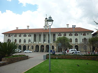
Pretoria railway station is the central station in Pretoria, the executive capital of South Africa. It is located between Pretoria's central business district and Salvokop, in a 1910 building designed by Herbert Baker. It is the terminus of various Metrorail commuter rail services in the northern part of Gauteng, and a stop on Shosholoza Meyl inter-city services from Johannesburg to Polokwane and Nelspruit. Pretoria is also the northern terminus of the luxury Blue Train service from Cape Town. Platforms and tracks for the Gautrain rapid-rail service are adjacent to the main-line station.
The following is a timeline of the history of Pretoria, in the City of Tshwane Metropolitan Municipality, Gauteng province, South Africa.
Hatfield is a metrorail station on the Gautrain rapid transit system in the suburb of Hatfield in Pretoria, Gauteng. It was opened on 2 August 2011 as part of the second phase of the Gautrain project.
Duncan Street is a street in eastern Pretoria, South Africa which forms a major north–south artery in the eastern part of the city. The street winds it way through Brooklyn Cycle and the suburbs of Brooklyn, Hillcrest, Hatfield, and Colbyn. In Colbyn it ends at the intersection of Glyns and Burns Streets.


