Queenswood | |
|---|---|
 Queenswood  Queenswood  Queenswood | |
| Coordinates: 25°44′46″S28°11′17″E / 25.74611°S 28.18806°E | |
| Country | |
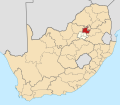
| Province | Gauteng |
| Municipality | City of Tshwane |
| Main Place | Pretoria |
| Area | |
| • Land | 2.62 km2 (1.01 sq mi) |
| Population (2011) [1] | |
• Total | 6,515 |
| Racial Makeup (2011) | |
| • White | 74,23% |
| • Black | 18,91% |
| • Coloured | 2,67% |
| • Others | 4% |
| First Languages (2011) | |
| • Afrikaans | 58,18% |
| • English | 29,12% |
| • Setswana | 2,10% |
| • Others | 11% |
Queenswood is a suburb in the northeast of Pretoria in Gauteng, South Africa. [1] It is bordered by Villieria to the north and Hatfield to the south.
Queenswood is home to the Eduplex Pre-School, Eduplex Primary School and Eduplex High School [2] as well as the Laerskool Queenswood. [3]